UAVs Revolutionise Land Administration
Fit-for-purpose Mapping
In 2014, a joint publication by the World Bank and the International Federation of Surveyors (FIG) entitled 'Fit-for-Purpose Land Administration' noted that 75 percent of the world’s population do not have access to formal systems to register and safeguard their land rights and, therefore, there is an urgent need to build affordable and sustainable systems to identify the way land is occupied and used. The emergence of small, affordable unmanned aerial system (UAS) technology and recent advances in highly automated mapping techniques offer a new tool and methodology for producing faster and cheaper spatial data that can benefit land administration agencies and help to secure property rights for millions around the world.
A World Bank team tested the use of UAS as a way to accelerate the production of fit-for-purpose spatial data, thereby allowing local and national governments and the private sector to use the up-to-date and accurate data for multiple purposes. The tests were conducted in Albania, which was chosen due to the urgent need for new and improved cadastral maps there.
Testing Low-cost Solutions
With the aim to test low-cost solutions, the team used off-the-shelf components and open-source software to the largest extent possible. The following major tests were successfully conducted:
- Rural mapping applications: a rural area was chosen to test whether unmanned aerial vehicles (UAVs) could be used to quickly and reliably deliver high-resolution orthophotos for administering compensation related to expropriations for infrastructure projects. The exercise was also used to test the technology for cadastral surveying with a strong component of citizen engagement. The resulting product, an orthophoto with 2cm accuracy, provided an absolute base against which the accuracy and relevance of existing spatial information could be checked
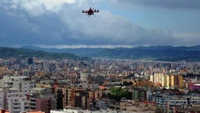
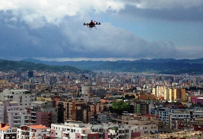
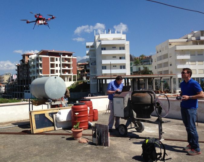
- Urban mapping applications (see Figure 1): an urban area was chosen to test whether UAVs could be used to provide detailed maps of densely developed urban areas with multi-storey buildings. 3D modelling using vertical photography was also tested
- Peri-urban applications: a peri-urban development was chosen to test whether UAVs could be used under production pressure in urban and peri-urban areas, and for legalisation/regularisation initiatives. Oblique photography was also added for enhanced 3D modelling.
Fit-for-purpose Land Administration
The joint World Bank-FIG publication defined the ‘fit-for-purpose’ approach as one that focuses on citizens’ needs rather than top-end technology. It should be flexible, attainable, reliable, inclusive, affordable, upgradeable and allow for stakeholder participation. The tests in Albania demonstrated that UAS technology is indeed fit for purpose as it includes the elements flexibility, inclusivity, participation, affordability, reliability and upgradeability.
Flexibility
Given the small form factor, low take-off weight, open source-driven flight planning, low acquisition cost and field reparability, UASs are flexible both in terms of ease of mobilisation and the specific purpose. The vertical take-off and landing (VTOL) capacity of the specific platform chosen for the Albania context allowed for engagements in rural as well as congested urban environments. Compared to conventional aerial photography methods, UAS technology is more adaptable to weather conditions, including dark cloud cover and winds of up to 8m/s.
Inclusivity
The team found that the equipment used could be employed in all types of terrain and environments, whether flat or mountainous, rural or urban. Thus, if mapping tasks are integrated with other related tasks, this technology can enable systematic photographing and mapping of all land within a country.
Participation
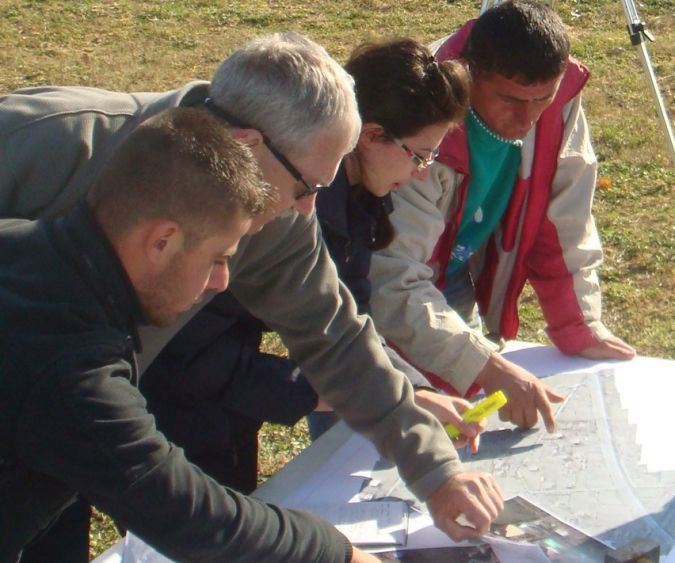
UAS technology benefits from local participation and engagement. During the tests, the team acquired images in the presence of the local inhabitants and then returned a few days later to test whether property owners would be able to demarcate their property boundaries by interpreting the orthophotos (see Figure 2). This approach of gathering and producing geospatial data promotes participation and facilitates citizen engagement in cadastral, planning and land administration activities.
Affordability
The components making up a simple yet effective, small mapping unit can be purchased for an amount equivalent to the price of one conventional geodetic global navigational satellite system (GNSS) rover unit. Affordability and relative ease of use make this technology feasible for small enterprises, implying that the formerly exclusive and highly centralised task of mapping can now be relegated from national mapping agencies to local mapping enterprises able to respond to local mapping needs at short notice. Hence, governments can plan and budget for locally sourced services rather than multi-million-dollar ‘one-off’ projects requiring complicated and time-consuming procurement procedures.
Reliability
The team found that the unit used during the work was 100% operationally reliable. The basic product of a UAV image acquisition operation consists of high-resolution (ground sampling distance between 1 and 5cm) aerial images which can optionally be georeferenced through the use of an integrated onboard GNSS receiver or by means of ground-controlled Structure from Motion map production. The contextual information contained in an unedited digital image is an objective record of a given situation and is, thus, not nearly as dependent on subjective interpretation as field notes collected by observers such as land surveyors. In this regard, UAV-derived high-resolution aerial photography delivers extremely reliable information that can be interpreted by all land administration professionals. Moreover, since UAVs can be called up at short notice, spatial information can be updated at much higher frequency and lower cost than would be the case with conventional wide-area updating routines currently being practised in most development scenarios. Therefore, UAV-derived aerial photography and mapping can play an instrumental role in well-managed and targeted verification and improvement of existing geospatial datasets.
Upgradeability
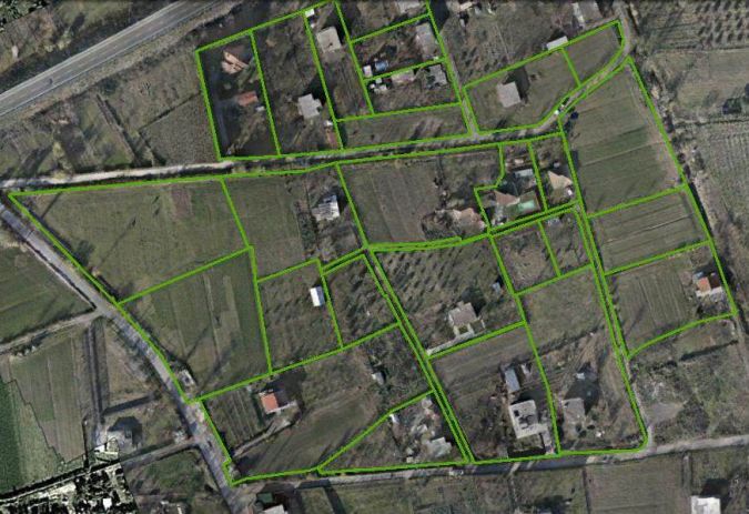
The cost-efficiency of this technology is further enhanced by the ability to ‘record now’ and ‘map later, if necessary’. For example, boundary adjudication results can be recorded by means of appropriate annotation directly on photographs or mosaics rather than on finished orthophotos (see Figure 3). The decision as to whether accurate geometry is needed can be left to the future. It is important, though, that all flight planning should provide for sufficient overlap to facilitate the production of maps at a date possibly much later than the date of photography or adjudication.
The Future of UAS in Land Administration
The tests in Albania show that UAS technology is a promising new tool for improved project design and implementation in which spatial data can be captured in a short time at a low cost (see Figure 4). Due to its rapid and easy deployment characteristics, UAS technology is most appropriate for short-notice acquisition of high-resolution digital aerial images over small areas. The technology’s highly automated and precise navigation is rapidly reducing entry barriers to mapping tasks.
The data can be used in many fields and applications, and governments, the private sector and international development partners such as the World Bank can benefit from these advances. However, as with all new technology, potential risks should be considered and managed carefully, especially since the legal and regulatory aspects lag behind. For example, data protection and data privacy, juxtaposed with the trend for broader public access to information and open data, are points that the use of UAS is bringing to the forefront of legal debates in many countries.
Concluding Remarks
Further use of UAS technology in the development-project context would benefit from general operational guidelines. Since the legal and regulatory framework for UAS operations is still evolving, and since UASs can be purchased or assembled at a very low cost, the World Bank and other development partners should have minimum standards for safety and operations that take into account social considerations in the country context. These standards are in no way meant to be burdensome for operators, to restrict vendors or to endorse one system over another. Rather, setting minimum standards related to equipment and operational safety, field mobilisation procedures, privacy and data protection requirements, and respecting local sensitivities, will reduce the likelihood of accidents and associated liability as well as the possibility of a public relations mishap. UAS technology has the potential to become an important tool in fit-for-purpose land administration and in increasing the number of people in the world who have access to more secure and inclusive property rights.
Further Reading
- Enemark, Stig; Bell, Keith; Lemmen, Christiaan and McLaren, Robin (2014) ‘Fit-For-Purpose Land Administration’, Joint FIG/World Bank Publication, FIG Publication No 60, http://www.fig.net/pub/figpub/pub60/figpub60.htm
- Barnes, Grenville; Volkmann, Walter; Kelm, Kathrine and Sherko, Romeo (2014) ‘Drones for peace: fast and inexpensive spatial data capture for multi-purpose use – part I of II’; World Bank Annual Land and Poverty Conference in 2014, https://www.conftool.com/landandpoverty2014/sessions.php
- Kelm, Kathrine; Tonchovska, Rumyana and Volkmann, Walter ‘Drones for peace: fast and inexpensive spatial data capture for multi-purpose use – part II of II’; World Bank Annual Land and Poverty Conference in 2014, https://www.conftool.com/landandpoverty2014/sessions.php

Value staying current with geomatics?
Stay on the map with our expertly curated newsletters.
We provide educational insights, industry updates, and inspiring stories to help you learn, grow, and reach your full potential in your field. Don't miss out - subscribe today and ensure you're always informed, educated, and inspired.
Choose your newsletter(s)


