Urban Planning, Management and Decision-making in the Cloud
SmarterBetterCities
SmarterBetterCities is a software company located in Zurich, Switzerland, which creates CloudCities: a cloud platform for smart city planning and smarter urban management. In line with the SmarterBetterCities’ mission – ‘to replace an army of specialists with a single web platform’ – CloudCities is a simple, smart and attractive platform for urban planning, putting decision-making at users' fingertips. Smart tools such as SmarterBetterCities’ 3D Cities Libraries offer solutions for instant city modelling and energy demand assessment.
Users can upload 3D city models using various file formats and show off their projects and significant context data, e.g. energy consumption, floor areas or renovation potential, by just using a web browser.
Together with current CTO Jan Halatsch, Antje Kunze founded SmarterBetterCities in December 2012 as an ETH Zurich spin-off. Before then, the duo had been working as research scientists since 2006 on several pan-European research projects. Most of their activities strongly involved investigating how information technology can facilitate sustainable urban planning. Their ties with ETH Zurich enabled them to gain exposure both locally and internationally and gave them access to professional networks around the globe.
There is still an enormous gap between the GIS and BIM industries nowadays, and great ideas are often lost in today’s interdisciplinary design process. That starts with the lack of tools to communicate thoughts and concepts. Just visualising the actual situation of a city is a time-consuming process, and the situation tends to worsen when data is exchanged (and unfortunately also lost) frequently between the project partners involved. Furthermore, during a design session it is typically difficult to include relevant key metrics such as the direct assessment of urban design scenarios with regard to costs, floor area and energy demands.
CityEngine
ETH Zurich has been at the forefront of technology for many years, continuously striving to tackle the above-mentioned issues using advanced technology. In early 2006, Antje Kunze and Jan Halatsch started to work with a tool called CityEngine, which had just been invented by Pascal Mueller and his peers at the ETH Zurich Computer Vision Laboratory. The tool offered exciting potential for urban planning applications. It was suddenly possible to recreate whole, realistic-looking cities in 3D using tiny computer scripts. These little scripts subsequently evolved into sophisticated programs which not only visualise highly detailed cityscapes but also translate complex zoning regulations and energy demand calculations into understandable urban forms. Interest was aroused from both the private and the public sectors. In the meantime, Esri acquired the start-up Procedural AG that released the commercial version of CityEngine. Hence, the CityEngine technology became part of the wide universe of the Esri ArcGIS platform, thus accelerating the demand. The company SmarterBetterCities was launched in response to the growing number of requests for custom solutions based on CityEngine modelling technology.
SmartZoning
One of the company’s first major contracts was to implement the city of Zurich’s zoning laws, which resulted in the SmartZoning product. This is a procedural 3D city model that creates legally solid 3D building envelope shapes. The city is using SmartZoning on a daily base. Firstly, parcel and land use data is uploaded as GIS layers. Then SmartZoning automatically triggers the procedural rules to generate the regular building envelopes for the underlying land use zone. The building envelopes precisely follow thresholds such as building dimensions, floor area ratios, open space requirements and setback information.
The researchers were keen to develop solutions that would make a difference on a large scale, so from an early stage the focus was on innovative tools for urban planning which would offer benefits to many cities (and people). European Union funding within the framework of Climate-KIC projects, which support products that can significantly lower the release of greenhouse gases, further accelerated the commercialisation of the SmartZoning tool and facilitated the development of an entirely new cloud service named CloudCities.
CloudCities
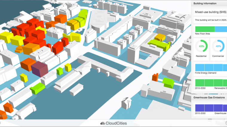
CloudCities is intended to replace sophisticated and complex urban planning and management tools that can only be handled by highly educated users. Thanks to CloudCities, cities with between 10,000 and 100,000 inhabitants that cannot afford a full 3D GIS stack but still want to become livable, lean and efficient ‘smart cities’ can upload and share their design scenarios using just a web browser on any modern device – computer, smartphone or tablet. CloudCities makes it easy to create clear visualisations out of complex GIS and CAD data. Users can customise dashboards using drag and drop to highlight the key metrics of their design or even the current state of their city. Moreover, within CloudCities it is possible to create cameras and animation paths that can guide people through vast urban scenarios. Various aspects of a construction project can be explored using intuitive controls through the information layers, and search features ensure that no details are lost. Sliders, toggle buttons and radio buttons give multiple control options for the display of information, including time ranges such as to illustrate the progress of a construction project. Once the preparations are complete, the online presentation can either be left inside CloudCities or it can be embedded directly in an external project web page or a project app. The end users of CloudCities range from individual citizens (public engagement) to CFOs of large government organisations.
In the most recent December release, support was added for Google Earth data (.kmz, .kml) and Collada (.dae). The Q1/16 release will include direct support for Autodesk FBX, Esri Multipatch (.shp and .gdb), Trimble SketchUp (.skp) and CityGML. These are all file formats which are heavily used in urban planning and management but typically in very different departments. CloudCities bridges the gap between them and enables the interaction between project partners by using and integrating digital data from all project parties.
Interoperability
Future releases of CloudCities 2016 will further increase the interoperability of features. Other plans include to ultimately integrate SmartZoning and 3D Cities Libraries into the cloud service. This will enable cities to quickly create 3D zoning plans, including sophisticated energy cost assessments, online by simply uploading their 2D cadastre maps to CloudCities and by applying SmartZoning to the parcel information. In turn, architects could validate their designs against the present zoning for a given parcel lot, for instance, and real estate developers could gain a better understanding of the real market value of land. A third-party data provider will provide direct access to vector maps, 3D buildings and climate, sensor and traffic data from within CloudCities.

Value staying current with geomatics?
Stay on the map with our expertly curated newsletters.
We provide educational insights, industry updates, and inspiring stories to help you learn, grow, and reach your full potential in your field. Don't miss out - subscribe today and ensure you're always informed, educated, and inspired.
Choose your newsletter(s)


