Verity-GeoSLAM Partnership Advances Real-time Construction Quality Management
The partnership between Verity construction verification software from ClearEdge3D and GeoSLAM’s ‘go-anywhere’ 3D mobile mapping technology promises to help architecture, engineering and construction professionals significantly advance their ability to verify as-built field data with design models. The next generation of construction quality assurance/control methodology and technology is integrating simultaneous localisation and mapping (SLAM) with building information modelling (BIM).
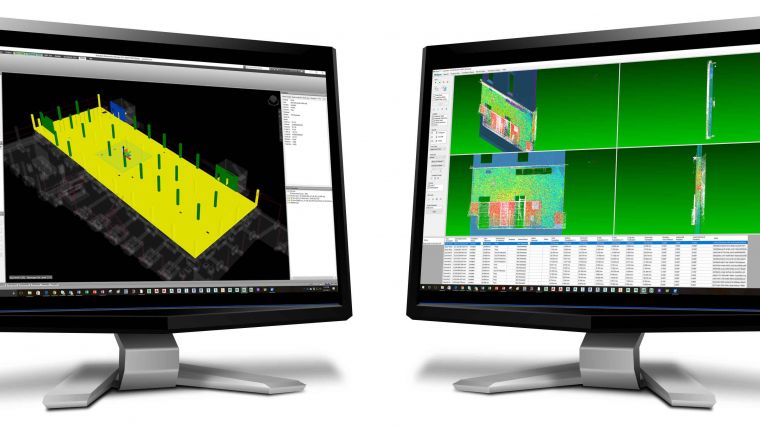
GeoSLAM and ClearEdge3D have announced an upcoming beta program that allows as-built construction data measured using GeoSLAM’s hand-held, lightweight mobile laser scanners to be compared against design/fabrication models using ClearEdge3D’s Verity software to quickly and easily identify installation status and out-of-tolerance or inaccurately constructed work.
Leading architecture, engineering and construction (AEC) firms from around the globe – users of both ClearEdge3D and GeoSLAM technologies – have been encouraging this innovation, according to Mark Reid, vice president of product management for GeoSLAM. He describes hand-held mobile laser scanning as faster and more accessible than traditional static terrestrial scanning, offering enormous savings, both in terms of verification time and reduced rework.
Now, nearly any member of a construction project team can use a GeoSLAM scanner to gather jobsite data for analysis. The need for traditional survey methodology is reduced because the ZEB-REVO is changing the economics of laser scanning, allowing users to scan more frequently – even daily. That data can then be analysed in Verity software to make sure the work is being built on schedule and within tolerance; identifying mistakes before they become expensive problems.
The plan is to have Verity do the same thing with SLAM data as it does with traditional terrestrial data – to very quickly and accurately verify installation status and tolerance, according to Kelly Cone, vice president of product management for ClearEdge3D. Although customers understand the value of terrestrial scanning, it can be cost prohibitive for weekly or daily use. Augmenting terrestrial scanning using GeoSLAM’s hand-held mobile scanners will give ClearEdge3D clients the freedom to scan as often as they want.

Value staying current with geomatics?
Stay on the map with our expertly curated newsletters.
We provide educational insights, industry updates, and inspiring stories to help you learn, grow, and reach your full potential in your field. Don't miss out - subscribe today and ensure you're always informed, educated, and inspired.
Choose your newsletter(s)


