Vexcel Imaging Launches European Aerial Image Library
Vexcel Imaging, a leading provider of aerial camera systems, mobile mapping platforms and fully integrated photogrammetry software, is launching one of Europe’s highest-quality and most up-to-date aerial image libraries. Starting in Germany, the cloud-based image library enables companies, public safety organizations and government agencies to save a significant amount of time and money. They will now find it quicker and easier to acquire up-to-date, concise and high-definition imagery and to leverage it organization-wide into critical location intelligence.
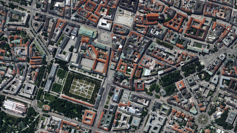
Starting with orthorectified imagery at 20cm resolution, the subscription service also includes near-infrared imagery and derivative data products such as digital terrain models, making it easy for organizations to integrate geospatial location information into their tools and workflows. For example, users can easily integrate GIS vector data over georeferenced aerial imagery to provide enhanced analytics, such as building change detection or basemap maintenance. Fast and easy access to the extensive dataset is made possible through Vexcel Web Services as well as standard application programme interface (API) methods.
Efficient acquisition of current imagery
“Acquiring current, accurate and useful imagery is a time-consuming and expensive challenge for organizations of all shapes and sizes across the globe,” said Alexander Wiechert, CEO of Vexcel Imaging. “Our goal is to solve this issue by making efficient acquisition of current imagery possible at anytime, anywhere. We’ve already seen strong success in pilot programmes leveraging the imagery for state and local governments in the United States and Australia and are excited to see how this library will further impact outcomes for other industries moving forward.”
Vexcel Imaging is in the process of capturing aerial imagery of Germany at 20cm with its UltraCam Condor Mark 1 Airborne System. In early 2020, the programme will expand its country-wide contiguous data capture across other European countries and further introduce the acquisition of major European cities at 7.5cm resolution vertical, orthorectified imagery including 45-degree oblique images, near infrared verticals along with derivative 3D data products collected with the UltraCam Osprey Mark 3 Premium Airborne System.

Value staying current with geomatics?
Stay on the map with our expertly curated newsletters.
We provide educational insights, industry updates, and inspiring stories to help you learn, grow, and reach your full potential in your field. Don't miss out - subscribe today and ensure you're always informed, educated, and inspired.
Choose your newsletter(s)


