Virtual Globes
State of the Art and Critical Issues
Virtual Globes (VGs) such as Google Earth or Microsoft Bing Maps 3D have in their few years' existence received enormous attention from both mass media and the geospatial community itself. VGs have raised public awareness of geospatial data and applications like no other technology before them. However, this has also birthed the question of whether they are just hype or offer substantial and long-term business opportunities for providers of geospatial data, technology and services. The authors look at this within the framework of a EuroSDR project.
The European Spatial Data Research network (EuroSDR) ‘Project on Virtual Globes (VG)' aims to determine the state of the art and critical issues concerning this technology in order to establish a network of users and providers and, in a second phase, investigate selected core issues. The first phase comprised a comprehensive online survey among experts from national mapping organisations and the geospatial industry. The second phase involved a EuroSDR workshop addressing a number of core issues identified by the survey results. We here present summaries of the two phases and proposed future activities.
Online Survey
The goal of the survey was to collect facts and opinions about VG technology and platforms; their application, the economic and political impact, geospatial base data (e.g. imagery, maps and elevation data), geospatial contents of VGs (e.g. 3D objects, 2D vector layers, raster layers or points of interests); quality issues, standardisation and extensibility. We also tried to establish an outlook and trends. Twenty-one questionnaires were returned, representing eleven European countries and about 12,000 staff, indicative of the considerable interest in issues surrounding VGs. This article offers selected questionnaire results. Detailed analysis of the survey can be found in the report, expected to become available on the EuroSDR website by mid-2010.
Geoportals
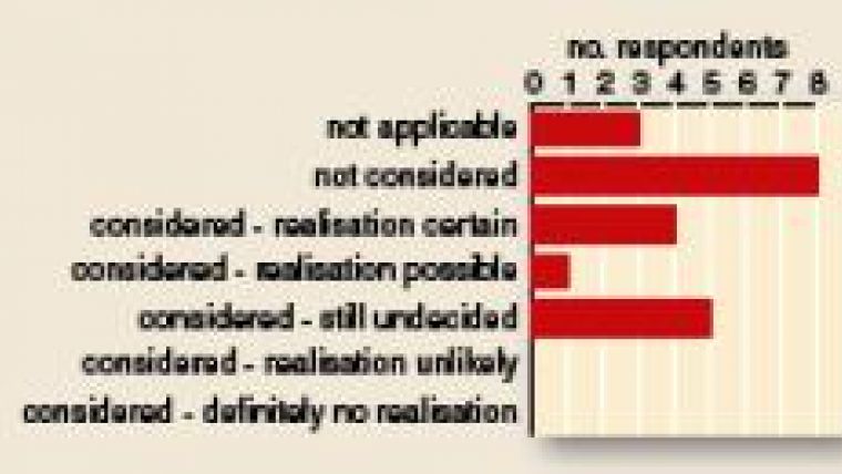
One set of questions concerned the establishment of national geoportals that include 3D information using VGs. Figure 1 shows that more than 50% of survey participants are considering or already planning the implementation of a national 3D Geoportal. Several participants underline the importance of these as alternatives to commercial VG platforms. However, there are also critical remarks and questions concerning the real need for converting existing 2D data to 3D. Many participants request co-ordination in efforts to establish 3D Geoportals and indicate that they would like to participate in such.
In-house Apps
Another question related to current and future uses of VG technology (Figure 2). In terms of the current situation, the use most mentioned was that of viewing standard VG contents, for example an elevation model with overlaid ortho-imagery, in combination with the contents of the own organisation. However, participants envisage a more important future role for tasks such as editing and capturing content, as well as geospatial collaboration. These future uses promise great potential for research and knowledge transfer in academia and mapping organisations.
Effects of VG
Respondents consider VGs have had a predominantly positive impact on their own organisation economically, politically and regarding corporate image. They are also thought to have had a positive impact on the GI industry within the respective geographical areas of survey participants. Nine reported changes to business strategies in the national GI industry as a result of VGs. Further mentioned is a positive effect on education in GI technology and on numbers of student following GI-related courses.
Challenges
Survey participants see few or no threats posed by VGs to national mapping organisations. However, they do identify a need for training and know-how in 3D geo-information within their organisations. They also indicate the presence of increasing demands on data and production, for example the challenge to provide adequate update rates, production capacities and data quality. Organisational adaptation of licensing and business models is identified as a challenge for coming years.
Positive Potential
VGs and 3D Geoportals are seen as vast global distribution channels for existing geodata, which could help reach new markets and customer groups. They are also seen as offering the potential for new applications and uses, such as geospatial collaboration within a shared and interactive (national) 3D geodata infrastructure. Survey participants identify several known quality issues associated with VGs, such as data currency (somewhat surprising), poor geometric quality of elevation data, or positional errors in ortho-imagery or other geospatial content. However, they do expect VGs to have a positive long-term effect on data quality (Figure 3).
Standardisation
The questionnaire results show that VGs are thought to have had a positive effect on standardisation so far, and that they are likely to do so in the longer term. The topic of standardisation in the area of VGs is considered highly important. Most participants think too that EuroSDR should play an active role in supporting such a standardisation process (Figure 5).
Workshop
Analysis of the survey identified 3D National Geospatial Data Infrastructures (3D NGDIs) and existing and future national 3D Geoportals as key issues. It was therefore decided the second phase of the project would include a Workshop on National 3D Geoportals and Virtual Globes. This took place on 21st September 2009 at FHNW University of Applied Sciences Northwestern Switzerland in Muttenz (Switzerland). The workshop, organised by EuroSDR and the FHNW, brought together experts and interested parties from organisations planning to establish 3D Geoportals, industry, and universities developing and researching current and future Virtual 3D Globe technologies. Also attending were existing and potential users of 3D Geoportals. The event attracted 59 participants from eleven countries; 46% from academia, 28% from national mapping organisations, and about 26% from industry. It was a well distributed group, in accordance with our goals which were to:
- assemble European experts to identify and discuss some core issues relating to VGs and (future) National 3D geoportals
- provide for exchange between experienced users, researchers, developers and other interested parties
- raise awareness among scientists about the demands and requirements of national mapping organisations with respect to VGs and National 3D geoportals.
Ethics and Trust
The workshop addressed research issues, applications, quality and legal issues, and comprised two plenary and four break-out sessions. The two plenary sessions with invited speakers focused on Strategy, Views and Legal Issues and on Technology, Standards & Applications; papers are available on the Workshop website. The break-out sessions dealt respectively with Interoperability, Strategies, Architectures, and Applications. All sessions were well attended and discussion took place in a lively atmosphere. A set of conclusions was collected for each topic, and these will be analysed in more detail. Two major issues raised during the workshop were the urgent need for standards for 3D geodata and 3D web services, and a multitude of questions concerning ethics and trust.
Follow-up
Based on outcomes of the workshop, the project team has proposed follow-up activities in the domain of 3D Geoportals and 3D Web Services to be supported by EuroSDR. First identified was the need for definition and establishment of an international test-bed for 3D Web Services and 3D Geodata standards based on the latest OGC specifications and recommendations. This test-bed should deal with Web 3D Service, Web Perspective Service and 3D SLD, and should be executed with the active participation of several national mapping organisations. Secondly, we aim for the dissemination and discussion of a proposed ‘3D Ethics Charter' (see website), setting out ethical standards for the use of 3D Geodata and 3D representations. Once core values and intentions are agreed upon for the Charter, it should be actively promoted among EuroSDR members.

Value staying current with geomatics?
Stay on the map with our expertly curated newsletters.
We provide educational insights, industry updates, and inspiring stories to help you learn, grow, and reach your full potential in your field. Don't miss out - subscribe today and ensure you're always informed, educated, and inspired.
Choose your newsletter(s)


