Wearable Reality Capture with Leica Pegasus:Backpack
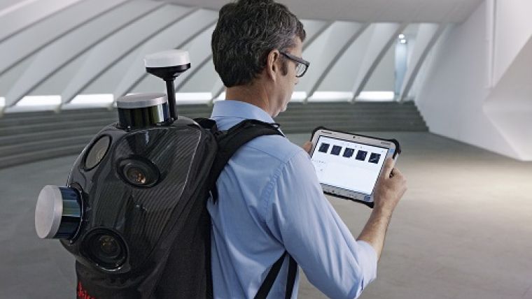
Leica Geosystems announced a wearable reality-capture technology with the Pegasus:Backpack at HxGN LIVE, which was held from 1-4 June in Las Vegas, USA. This mobile mapping solution combines five high-dynamic cameras, which work in a variety of light conditions, and a Lidar profiler with an ultra-light and ergonomic carbon-fibre chassis. The result is a 3D view indoors or outdoors for engineering or professional documentation creation at the highest level of authority.
For Building Information Modelling, or BIM, or simply for capturing 2D square foot updates to a large building, the Leica Pegasus:Backpack creates a very realistic view by capturing synchronised imagery and point cloud data. Accurate positioning is achieved in GNSS-restricted areas using Simultaneous Localisation and Mapping, or SLAM, technology. Together with a high precision inertial measurement unit, the Leica Pegasus:Backpack is a true position-agnostic solution.
Lidar
This new technology is designed to enable weekly data capture efficiently and cost effectively for changing building construction sites. This enables the creation of a full starting document for authoritative 6D management of a building or simply to provide an authoritative hand-off dataset to a new building owner. By capturing weekly during a building’s construction, an “x-ray” view of the building is created. As the Backpack clearly logs position and time with the advanced measurement of Lidar, change orders in the construction process can now offer a complete new level of authority for quality construction while scheduled milestones are achieved.
With full 360-spherical views and Lidar together plus a hardware light sensor, all images are usable while other functions are verifiable and adjustable over the operator’s tablet device. The system uses multiple hot-swappable batteries, making even long captures possible.
With the Leica Pegasus:Backpack, limited-access outdoor areas or underground infrastructures are no longer limited in professional data collection, said Stuart Woods, Geospatial Solutions Division vice-president. Users will never again forget any aspect of any job nor need to return to a project site. They can capture everything by simply arriving on site wearing the technology, capture and leave, rest assured they have everything they need to complete the job on time and on budget.
Workflow
Working with images and point clouds together, data is captured into a single platform and workflow – from the operator interface to a single-click post-processing to feature Meta tagging. Leveraging Leica’s Mapfactory extension, features can be extracted and datasets can be exported to CAD or BIM specific software solutions. More effective decision making is finally achieved with 3D spatial models that allow for true life cycle building planning, enabling 6D BIM.
Further information about the Leica Pegasus:Backpack can be found here.

Value staying current with geomatics?
Stay on the map with our expertly curated newsletters.
We provide educational insights, industry updates, and inspiring stories to help you learn, grow, and reach your full potential in your field. Don't miss out - subscribe today and ensure you're always informed, educated, and inspired.
Choose your newsletter(s)


