Web-based Lidar Data Processing
The use of 3D laser scanning is growing enormously, and the amount of data is growing accordingly. It is becoming increasingly difficult to acquire the in-house technical capability to store, manage and analyse this massive volume of data. The flood of laser scanning data demands more effective tools that have greater automation, lower cost and more accurate results. With the above requirements in mind, GeoSignum has been developing new tools and technologies for automated analysis and interpretation of huge Lidar datasets which can be accessed through its web-based Pointer platform.
Because the Pointer platform is cloud-based, the user no longer has to worry about storing, accessing, managing and analysing their huge volumes of Lidar datasets. They simply upload their dataset to the Pointer platform and easily access their data through a web-browser.
On-the-fly 3D point cloud processing in the cloud
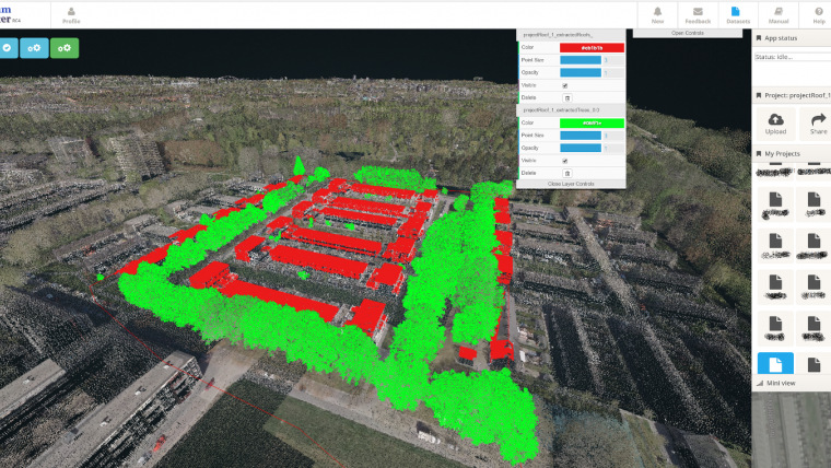
After accessing the data through a web-browser, the technologies developed by GeoSignum enables the user to select which feature to extract of the laser scanning dataset. For example, all the trees or rooftops in a scanned area (see image). The software then automatically recognizes, extracts and visualizes the desired feature. In addition, more advanced analytics can be performed on the extracted features, such as determining its size, position and some other properties. An entire city or hundreds of kilometers of highways and railroads can be analyzed and features of interest can be extracted extremely fast and with high accuracy. This enables more effective monitoring of highway/railway and urban assets or infrastructures so that problems can be found and addressed quickly using only a web platform. Also, this way of processing Lidar data is cost-effective, less labor-intensive and less time-consuming. With this fully tested platform, users are able to experience all features on the fly in the cloud without needing plugins or powerful hardware infrastructure.
Extract information from massive size Lidar datasets
GeoSignum has recently announced the 2nd version of the web-based Lidar data processing platform: Pointer V2.0. In addition to new analysis tools, the number of features that can be extracted and analyzed has been expanded and currently includes: rooftops, trees, crash barriers, street lights, road signs, curbs, diverse point cloud classification modules, among many others.
With GeoSignum Pointer web-platform, users can immediately access terabytes of Lidar data via a web-browser, create and manage an unlimited amount of projects, share projects and collaborate with colleagues online.
About GeoSignum
GeoSignum is a young innovative start-up company and part of tech incubator YES!Delft, based in Delft, The Netherlands. GeoSignum develops technologies to automatically model and extract geographical objects and information from 3D laser datasets captured from various platforms, such as Mobile, Airborne and Terrestrial Laser Scanning.

Value staying current with geomatics?
Stay on the map with our expertly curated newsletters.
We provide educational insights, industry updates, and inspiring stories to help you learn, grow, and reach your full potential in your field. Don't miss out - subscribe today and ensure you're always informed, educated, and inspired.
Choose your newsletter(s)


