Which Photogrammetry Solutions Are Surveyors Waiting For?
Exploring the Demands of Geoprofessionals
How can photogrammetric equipment and software developers provide the mapping and surveying community with solutions that are sophisticated, yet also meet high customer expectations in terms of user-friendliness?
Photogrammetry is a well-established technique for acquiring dense 3D geospatial information. In fact, the method is as old as modern photography, dating back to the mid-19th century. The science has continued to evolve over time, of course, and – especially in view of the recent advancements in computer vision and machine learning – the technology is no longer as simple as it may seem. Developers of photogrammetric equipment and software face the challenge of providing the mapping and surveying community with solutions that are sophisticated, yet also meet high customer expectations in terms of user-friendliness. At 'GIM International', we conducted a survey among our readers in the geospatial industry to gain insights aimed at helping manufacturers to further optimize the solutions on offer. This article presents our findings.
Before examining the results of the GIM International readers’ survey on photogrammetry, let us first zoom in on the ongoing debate about photogrammetry versus Lidar. Is it fair to say that one mapping method is definitively better than the other? Or is the situation more nuanced than that?
Lidar
Data that is captured by either photogrammetric or Lidar mapping technology is gathered in a point cloud. An often-heard question is whether photogrammetric point clouds are superior to Lidar ones, or vice versa. The best answer is probably that there is no clear-cut answer; it depends on the application. Although Lidar mapping may deliver a higher level of detail, photogrammetry is usually sufficiently detailed for large areas, for example. The fairest conclusion is that each system has advantages and disadvantages. Our survey reveals that photogrammetry is a far more popular geodata acquisition technology for mapping projects than Lidar (photogrammetry 73%, Lidar 27%). The three most popular laser scanning processing software packages are Leica Cyclone, Terrasolid and CloudCompare. However, the demand for Lidar solutions is growing. About a third of the respondents indicate they are planning a major investment in laser scanning devices, and a similar number intend to purchase laser scanning processing software. Lidar in particular is an often-used method for the generation of digital elevation models (DEMs).
Topographic mapping and cadastral surveying
There are two categories in which photogrammetry is most popular by far. One is topographic mapping, for which 60% of surveyors indicate that they prefer this technique. Topographic maps are used for a wide variety of applications, such as construction, mining, land use surveys, urban planning and civil engineering. The traditional approach to updating topographical maps can be time-consuming and expensive, but a digital photogrammetric environment offers a way forward. Here, 3D point cloud data is created by applying image matching to overlapping digital images. Cadastral surveying is the second area in which photogrammetry is regarded as a highly effective method. The main advantage is that it can be just as accurate as a ground survey, yet much more affordable. However, when land is covered by obstacles such as trees, additional survey equipment such as a total station and GNSS receiver can be necessary.
Combining Lidar and photogrammetry
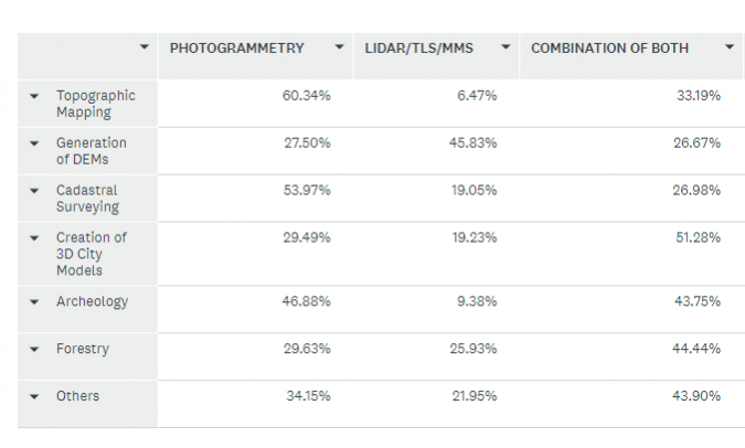
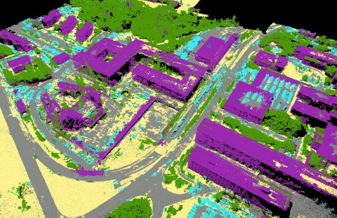
Following on from the above, and perhaps only logically in view of the advantages and disadvantages of the two methods, there is a growing tendency to combine them both (Figure 1). More than half of the survey participants rely on photogrammetry plus Lidar for the creation of 3D city models, for instance, and archaeology and forestry are also high-ranking applications. When surveying an archaeological site, for example, UAV photogrammetry with both nadir and oblique cameras is often combined with the large-scale details acquired by terrestrial laser scanning of vast areas or complex objects. In forestry, Lidar-derived DEMs and photogrammetric canopy surface measurements are both suitable for providing relevant geospatial information relating to forest canopy structure. Contrary to Lidar, photogrammetry cannot penetrate vegetation canopy, but photogrammetric matching of digital aerial images is a cost-effective and reliable solution. So here, too, a combination seems to make perfect sense.
Photogrammetric software
There are numerous software solutions available on the market for the photogrammetric processing of digital images and to generate 3D spatial data. Geoprofessionals can use the photogrammetric software to create orthomosaics, point clouds and models. Some photogrammetric software solutions are suitable for large-format images from aerial cameras and satellite processing, while others are especially developed for small and medium-format digital images acquired by unmanned aerial vehicles (UAVs or ‘drones’). The Pix4D and Agisoft PhotoScan software solutions are currently way out in front, according to our survey. In a thorough comparison of household names in the geospatial industry by Michael Schwind and Michael Starek in an edition of GIM International in 2017, they were both found to be very close in terms of density, spacing and number of points. Apart from Pix4D and PhotoScan, respondents frequently mentioned Inpho (Trimble), ContextCapture (Bentley), DroneDeploy, Photomod (Racurs), Correlator3D (SimActive) and SURE (nFrames) as their software of choice.
Valued characteristics
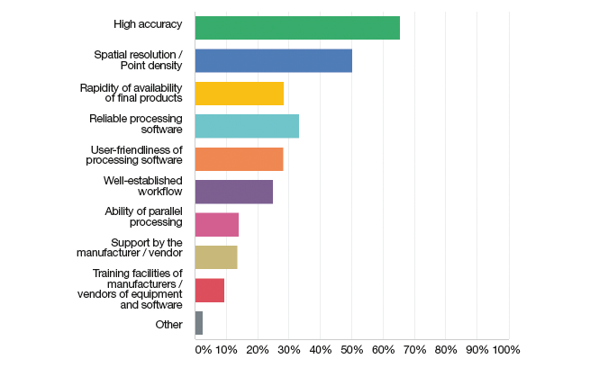
We also asked our readers what they valued most about their chosen geodata acquisition method, and the answers will undoubtedly be of interest to providers of photogrammetric solutions. At the top of the list of priorities (Figure 2) is high accuracy (more than 65%), followed by spatial resolution/point density (just over 50%) and reliable processing software (33%). Other important aspects are the rapid availability of final products and a well-established workflow.
It is hardly surprising that accuracy is regarded as essential. However, accuracy is affected by several factors. PhotoModeler Technologies (also known as Eos Systems) published a relevant blog titled ‘Factors Affecting Accuracy in Photogrammetry’ analysing the various aspects of photogrammetric accuracy. According to the blog, high accuracy is related to photo resolution, camera calibration, angles, photo orientation quality, photo redundancy and targets/marking precision.
One particularly important aspect is knowledge of how to gather the best imagery. After all, of the various factors that affect the accuracy, the quality of the input imagery is crucial. Photogrammetric mapping companies are always working on optimising their solutions, but geospatial professionals themselves can also do a lot to improve the results. It may sound obvious, but high-quality inputs lead to high-quality outcomes.
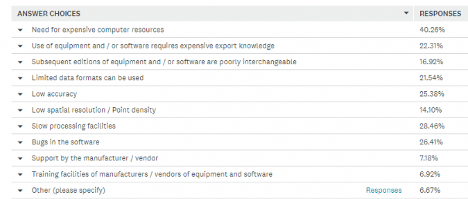
What geospatial professionals dislike
To gain a true picture of the photogrammetric market, we also asked our readers which characteristics of their chosen geodata acquisition method they dislike most. Their responses (Figure 3) make it clear that suppliers of photogrammetric solutions still have some work to do. Common complaints range from discontentment about the need for expensive computer resources (40% of the respondents mention this) to slow processing facilities (28%) and bugs in the software (26%). The limited number of data formats that can be used (21%) and the fact that the use of equipment and/or software requires extensive export knowledge (22%) are also common annoyances of the survey participants. Hopefully this feedback will give manufacturers of photogrammetric solutions food for thought in their further development processes.
User experiences
To gain deeper insights into practical usage, we asked our readers to summarise their experiences, both pros and cons, with the photogrammetric products they are using. This resulted in a wide variety of reactions, but there are several recurring topics. One of the most frequently expressed hands-on experiences revolves around complications with image format processing during analysis. Another gripe by several respondents is the need to know photogrammetry in order to use the package appropriately. But it is not all bad news; there is also a lot of positive feedback, such as that, for academic purposes, the equipment and software programs are very useful in obtaining orthophoto maps and maps in the GIS structure. On another positive note, one experienced surveying professional comments that, over the years, photogrammetric methods of geodata collection and applications have achieved obvious improvements in the quality and also the rapidity of processing huge volumes of 3D geodata.
In general, the survey participants seem satisfied about the products they are using. However, there is still plenty of room for improvement. “Extensive training on equipment, workflows and delivered products to end customers are required,” states one respondent. Another frequent complaint is that the hardware is expensive and the software has a limited licence. “There is a lack of consistent workflow between software packages,” one reader notes. Needless to say, the specific application also plays a role in how software is rated. As one respondent puts it, although the chosen solution may not be best-in-class software, it provides the “fit-for-purpose” output that clients want at a cost-effective price.
Optimally meeting users’ needs
The question that will probably spark the most interest among manufacturers and developers of photogrammetric equipment and software solutions is ‘What would geospatial professionals suggest to manufacturers of photogrammetry solutions to help them ensure their products optimally suit their needs?’ Our survey generated a wealth of information, of course, but the key insights can be summarised as follows. Firstly, automatic procedures to analyse and extract information from 3D point clouds are high on the wish list. Versatility, ease of use and low costs are also mentioned often. This will make photogrammetry accessible to a wider range of users, including non-traditional photogrammetry users, some of the respondents argue. There also seems to be a growing demand for software that is able work with Lidar, aerial photography and UAV data in a single-window environment. A significant number of respondents call for interoperability between data formats and/or sensor formats from different manufacturers. Several readers also indicate that the rise of UAVs in the geomatics field will require adjustments from providers of photogrammetric solutions.
Willingness to invest in photogrammetry
In an attempt to assess the future of the industry, we asked the survey participants two questions with regard to their plans to buy new photogrammetry equipment and processing software. In response to the question ‘When will be your next major investment in photogrammetric equipment?’, almost half of the respondents indicate ‘Before 2020’. On the other hand, around 30% still need to be convinced of the necessity to invest in new equipment as they currently seem unwilling to make a financial commitment.
In terms of their intention to make a major investment in processing software, 45% of the survey respondents state that they plan to do so before 2020, while 18% expect to make their next significant purchase between 2020 and 2022. Once again, approximately 30% have no plans to invest.
Future outlook
Looking ahead to the future of photogrammetry, one respondent in our readers’ survey made a particularly bold and thought-provoking statement: “Photogrammetry in the traditional sense will disappear in 5-7 years. The first such unnecessary process is the measurement of the heights of the points and the construction of the DEM. Real technologies can only be the construction of orthomaps and engineering photogrammetry”. While we are not able to look into our crystal ball to see whether this is indeed true, there is certainly enough innovation in the industry for us to be able to predict that things will transform. Advancements in computer vision, artificial intelligence and machine learning are already adding new dimensions to photogrammetry. Bearing in mind that it is still very much early days for these technologies, we are in no doubt that exciting and inspiring times lie ahead!
Further Reading
Ahmad, F., Uddin, M. and Goparaju, L. (2018), 3D Mapping by Photogrammetry and LiDAR in Forest Studies, World Scientific News
Schwind, M. and Starek, M. (2017) Producing High-quality 3D Point Clouds from Structure-from-Motion Photogrammetry, GIM International
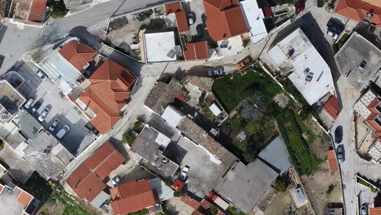
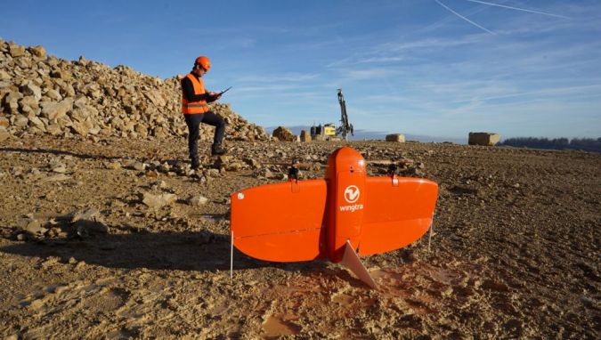
Cover image: up2metric (www.up2metric.com)

Value staying current with geomatics?
Stay on the map with our expertly curated newsletters.
We provide educational insights, industry updates, and inspiring stories to help you learn, grow, and reach your full potential in your field. Don't miss out - subscribe today and ensure you're always informed, educated, and inspired.
Choose your newsletter(s)


