Settlement Patterns of Ethnic Groups
A GIS-based Method
This paper implemented Geographic Information System (GIS) technology to explore the settlement patterns of ethnic groups in Nan, Thailand, in relation to geographic factors. The general findings reveal that people of the same ethnic group tend to live in a clustered fashion. In addition, ethnic groups located at an elevation of 200-500 metres above the mean sea level tend to live near both roads and rivers (within 1 kilometre), while those on higher elevations tend to live further away from roads and rivers. Furthermore, the unique characteristics of the settlement patterns of each ethnic group have also been identified.
An introduction to GIS is provided in the next section with a focus on understanding the geographic technology used in this paper. The procedure for using GIS technology, the study area and dataset, the results and the analysis are then explained respectively.
Geographic Information System
Geographic Information System (GIS) technology has emerged as a computer system which is capable of capturing, querying, analysing and displaying geographic data. In terms of spatial analysis, GIS provides the capability to analyse and produce valuable information for better decision-making, which has a multitude of advantages over a wide range of GIS-related applications. Geostatistics functions have been included in GIS as an extended functionality to allow statistics to be applied to geographic data. Such functions have bridged the gap between statistics and geography to enable the successful analysis of spatial phenomena.
Methodology
In order to reveal geographical characteristics of where the ethnic groups choose to live, analytical GIS functions were employed to derive spatial relationships between settlement locations and surrounding geographical factors, as well as the degree of spatial clustering of ethnic populations. Four groups of GIS functions were used in this paper: surface interpolation, overlay, proximity and geostatistics. Combining the results from these functions provides knowledge about the settlement patterns of ethnic groups in Nan, Thailand.
Study Area and Dataset
The area of interest covers the whole province of Nan, approximately 12,200 square kilometres. Nan is located in the northern region of Thailand, and its eastern mountainous border is adjacent to the Lao People's Democratic Republic (Lao PDR). Nan consists of 15 districts which are divided into 99 sub-districts comprising a total of 902 villages between them. Since the northern part of Thailand has borders with Burma and Lao PDR and is close to China, provinces along the border normally have a number of ethnic groups. Nan has at least 13 ethnic groups living in its provincial area. This paper concentrates on seven selected major ethnic groups: Maung, Tai Lue, Lao, Mong, Yao, Tin (Prai), and Tin (Mal). The population and number of village locations of each ethnic group are listed in Table 1. The dataset used consists of five data layers comprising village locations of the seven ethnic groups, contour lines, road centrelines, river centrelines, and administrative boundaries.
Different Heights
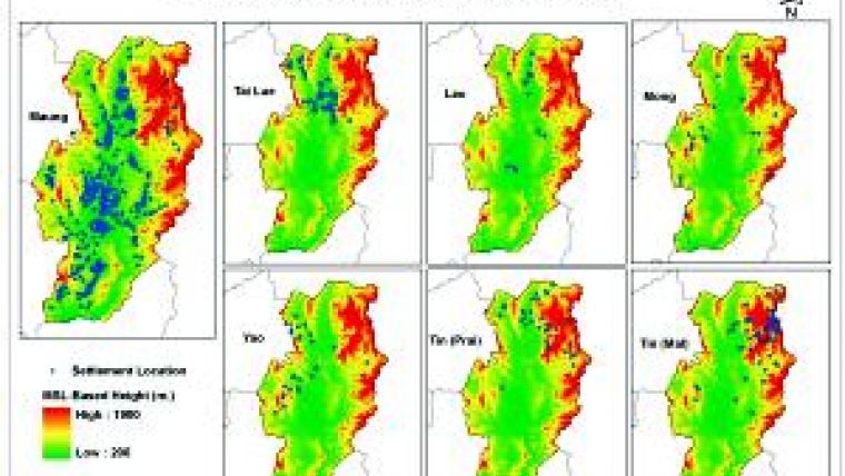
In order to obtain the topography characteristics of each village, the contour line was first input into the interpolation process to produce the surface elevation, slope and aspect data layers. The village layer was then overlaid on the three layers, one at a time, and the attributes of elevation, slope, and aspect were transferred to village points by the intersection function. The elevation, slope and aspect of where ethnic groups were located, based on the villages' locations, were plotted as shown in Figures 1, 2 and 3 respectively.
It was found that most of the villages occupied by the local Thai ethnic group, called Maung, are scattered throughout Nan in areas with an elevation of between 200-500 metres above mean sea level (MSL). The Tai Lue and Lao ethnic groups also live in the areas at less than 500 metres above MSL. Villages inhabited by Yao are mostly at less than 600 metres above MSL, while villages of Mong and Tin (Prai) are on the higher land at up to 1,000-1,300 metres above MSL. Most villages of Tin (Mal) are in the areas higher than the others, which is up to 1,600 metres above MSL, in the mountainous area in the north-east of the region.
Most areas of the Nan province have slopes of less than 20 degrees, as shown in Figure 2. The steeper slopes are located in the areas along the provincial boundary especially along Thailand-Lao PDR border, while the more gentle slopes are located in the inner part of the province. Most villages of Maung, Tai Lue, and Lao are located in flat areas, while more than half of the villages of the others - Mong, Yao, Tin (Prai), and Tin (Mal) - are in areas with slopes of up to 30 degrees.
Locations
Aspect describes the direction towards which the facets of a surface are facing. As shown in Figure 4, the villages of Maung, Tai Lue, and Lao are mostly located in flat areas so no aspect is given in these areas. About 52% of Mong villages are on the north-east and south-west aspect. 51% of Yao villages are located facing east; since Yao villages are mostly located on the west side of Nan, facing to the east means facing in-bound to Nan territory. Meanwhile, Tin (Prai) and Tin (Mal) tend to live facing west more than facing east; since they are located on the east side of Nan, facing west likewise means facing in-bound to Nan territory.
Proximity analysis measured distances from the village locations to the nearest roads and rivers. Most people of Maung, Tai Lue and Lao who live in flat areas are within a distance of 1 kilometre from both rivers and roads. Among the seven ethnic groups, Mong have the highest number of people (33.3%) living far from both rivers and roads, at a distance of more than 1 kilometre, while Yao have the second highest at 23.4%. Approximately 85-90% of Tin (Prai) and Tin (Mal) people live near roads (within 1 kilometre) and only small numbers of them live further than 1 kilometre from both rivers and roads.
After applying the ‘nearest neighbour' method to each group's village locations, the resultant distribution indices were measured. Lao and Tai Lue have the most clustered distribution among the seven ethnic groups in Nan, with an index of 0.19 and 0.28 respectively. Maung, Yao, Tin (Prai) and Tin (Mal) have a clustered distribution at the same level with indices of 0.5-0.6, while Mong have the lowest clustering level (0.72) out of the others. The resultant indices show that each ethnic group tends to settle close to members of the same ethnic group but with slightly different degrees of clustering.
Analysis of the Results
It has been found that the Maung, Tai Lue, and Lao ethnic groups normally live in flat plain areas near roads and rivers. On the contrary, only about one third of Yao, Mong, Tin (Prai) and Tin (Mal) live on flat plains, while the rest are spread over areas with up to 30-degree slopes and higher elevations. Yao prefer living near rivers compared to roads, while Tin (Prai) and Tin (Mal) prefer roads to rivers. It has been shown that one-third of Mong live further from both roads and rivers. This implies that Mong have the least accessibility to both transportation and water resources. Therefore, Mong might be considered as one of the most conservative ethnic groups in Nan. In terms of aspect, the village locations across Nan show that Yao, Tin (Prai), and Tin (Mal) are all facing towards the flat plains of inner Nan.
Acknowledgements
Thanks are due to the Faculty of Arts, Chulalongkorn University, and Professor Dr. Theraphan L-Thongkum.
| No.
| Ethnic Group
| Population
| Number of Villages
|
| 1
| Maung
| 296,758
| 608
|
| 2
| Tai Lue
| 50,324
| 81
|
| 3
| Lao
| 9,672
| 14
|
| 4
| Mong
| 21,954
| 17
|
| 5
| Yao
| 10,347
| 14
|
| 6
| Tin (Prai)
| 10,884
| 26
|
| 7
| Tin (Mal)
| 24,450
| 52
|
Table 1, Number of people and village locations of the seven selected ethnic groups in Nan.

Value staying current with geomatics?
Stay on the map with our expertly curated newsletters.
We provide educational insights, industry updates, and inspiring stories to help you learn, grow, and reach your full potential in your field. Don't miss out - subscribe today and ensure you're always informed, educated, and inspired.
Choose your newsletter(s)


