7 Ways Cities Benefit from Digital Twins
According to the World Economic Forum, the current 4.2 billion people living in urban areas will increase by 2.5 billion by 2050. This increase means that cities and supporting ecosystems must deliver on housing and infrastructure needs while also addressing quality of life, economic growth, safety and security, and resiliency. Assets are becoming increasingly vulnerable to climate-related forces: rising sea levels, drought, seismic activity and violent storms. Cities seek solutions to help them both minimize chronic stress on current infrastructure and mitigate, respond to and recover from the acute shocks of earthquakes, floods and other catastrophic events. This article highlights seven ways in which advancing technology can help.
(This article is brought to you by Bentley Systems)
To address these very real challenges, each city data owner needs to make accurate and relevant infrastructure information accessible across necessary departments, to the city ecosystem, and often to citizens.
It is important to trust that information used to support city infrastructure and services is complete and accurate. It is also important to have data help drive decision making when considering the effects of chronic stress on current infrastructure. And, it is important to have access to trusted data that can help to mitigate, respond to, and recover from acute shocks, such as those caused by weather-related events.
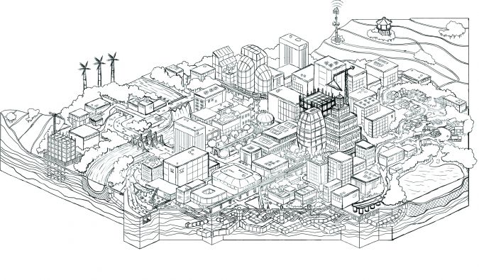
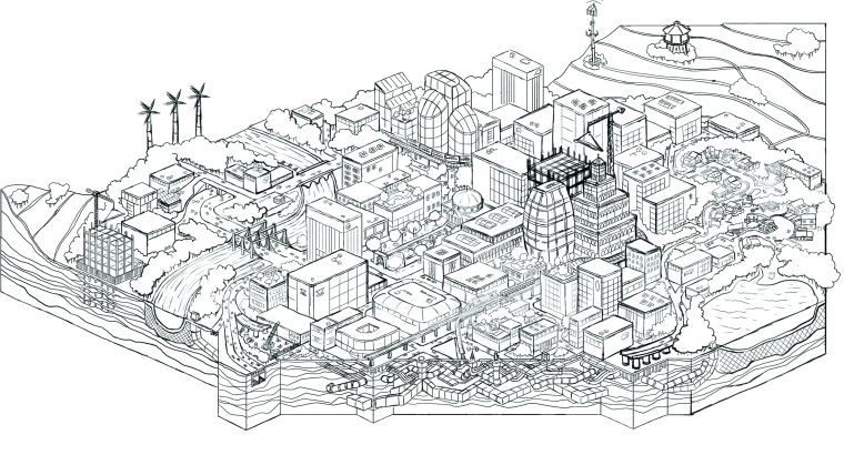
City departments, its infrastructure, residents, and buildings are digitally advancing. With new technologies – such as Industry 4.0, the Industrial Internet of Things (IIoT), sensors, RFIDs, smart phones, and cloud services – cities can provide a range of new and enhanced services to residents. At the centre of this digital advancement in many industries are digital twins, a digital representation of a physical asset, process, or system, as well as the engineering information that allows us to understand and model their performance. Digital twins enable asset-centric organizations to converge their engineering, operational, and information technologies for immersive visualisation and analytics visibility. Made possible by advancing technology –such as the convergence of 3D/4D visualisation, reality modelling, mixed reality, and geotechnical engineering – digital twins provide an immersive and holistic view of infrastructure assets above ground and below ground.
“The power of a digital twin is in its ability to help decision makers derive new insights and inform better decisions, providing a holistic visualisation of infrastructure asset information and performance,” said Robert Mankowski, vice president digital cities, Bentley Systems.
To gain a clearer understanding of digital twins, I offer seven ways in which city governments can benefit from advancing technology to improve efficiencies.
- Gather insights that improve city infrastructure
While several cities have developed digital footprints using reality modelling, they are often no more than visually appealing 3D models. This is because different departments use different systems to manage data associated with their specific workflows and infrastructure assets. The data exists in a variety of formats – CAD, BIM, and GIS, engineering models, spreadsheets, databases, documents, real-time and historic IoT data streams, photos and point clouds. The data constantly changes, which makes it difficult to access and know that you have the right information at the right time.
By implementing an open, connected data environment (CDE), you can gain quick access to semantically rich models and know that they are accurate and up to date. “With Bentley iTwin® Services, an open-source framework for creating infrastructure digital twins, cities can federate data – whatever the engineering applications and BIM capabilities, repositories and file systems, or file formats and schemas might be,” said Mankowski. “This federated approach enables an actionable digital twin of the city with data-driven analysis, modelling, and simulation, improving asset definition, configuration, geospatial location, and change management throughout asset lifecycles.” Using these capabilities, city stakeholders can maximise operational budgets by extending the life of assets and equipment, making trusted information available whenever and wherever it is needed to support city infrastructure and services.
- Improve collaboration across a vast ecosystem of city stakeholders, creating additional value for cities and residents
All stakeholders – from city departments, to the city ecosystem, to the city’s residents – benefit from a collaborative approach to information. Highways, bridges and tunnels, rail, and other transit infrastructure are built, operated, and maintained within and between cities. So, it makes sense that these groups would benefit from effective collaboration. City operations, planning, and economic development, as well as emergency services and utility operators, all need to collaborate and share information with transportation agencies to improve decision making that results in the support of each group’s initiatives. Thus, with a holistic approach to consuming and sharing information, infrastructure owners know that they have the latest information on existing conditions before projects begin. Moreover, by having the most accurate information, stakeholders can be more proactive when they plan for interruptions and communicate transportation and utility projects to the public, helping them avoid project areas. Additionally, this information enhances the city’s ability to deliver on its promise of greater transparency, while communicating its vision for mobility and other infrastructure improvements.
Most cities experience a constant and simultaneous stream of projects at varying stages of completion, from transportation to utilities to buildings. For each project, the infrastructure owners and developers must consider the subsurface environment. The creation and curation of subsurface digital twins involves modelling the underground environment – geology, hydrology, chemistry, engineering properties – and the underground infrastructure – structures, tunnels, and utility networks. There are cautionary tales of the risk associated with this underground environment and the aftermath, where geotechnical teams are challenged to make right what is wrong, such as the sinking San Francisco Millennium Tower. Subsurface digital twins can be vital for assessing and managing risks throughout an infrastructure project, including through operations and maintenance.
“By its very nature, the physical underground environment is hard to visualise and comprehensively survey, so a digital twin that brings together the available data, makes it easily accessible for engineering analysis, and provides 4D visualisation capabilities can greatly improve understanding of the subsurface,” said Mankowski.
- Improve mobility and safety in public spaces – even when hosting large events
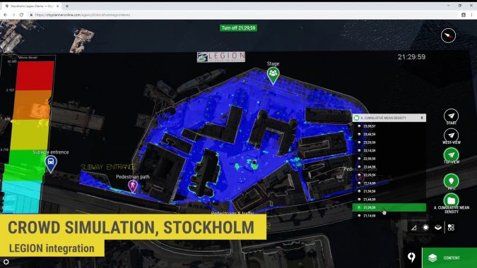
Digital twins help optimise how space is used to improve planning and designing of buildings, as well as to improve safety, efficiency, and revenue. They also provide users with the ability to simulate and analyse foot traffic on or in infrastructure assets, including rail and metro stations, stadiums, shopping malls, and airports. Using digital twins, engineers and designers can accurately test designs and operational and commercial plans to enhance footfall, wayfinding, crowd management, safety, and security.
- Improve urban planning and project visualisation
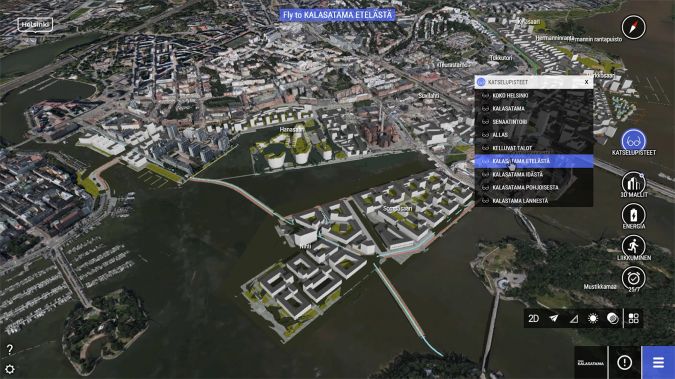
With this technology, urban planners can stream large-scale digital twins online to visualise projects spanning entire cities down to the street level using a combination of terrain models, reality meshes, and semantic 3D city models. The technology allows urban planners to achieve a higher level of detail in their plans. Building owners also play a unique role in helping cities advance digitally. When intelligent models are associated with individual buildings, urban planners can merge these models into a citywide digital twin, making the information about the city even more intelligent. Using digital twins to engage developers and building owners during planning helps to influence the new or renovated space through incentives and zoning to ensure what is developed improves the residents’ quality of life.
- Make infrastructure resilient: predict, respond, and recover from acute shocks
Extreme hydrometeorological events, combined with rapid urbanisation and inadequate draining substructures, trigger flooding and cause major damage to infrastructure, while impacting human safety and weakening the economy. To avoid flood risks and minimise the impact of a heavy rainfall, urban planners need to implement flood resilience technology that helps them comprehensively manage flood risks and rapidly recover from any disruptions caused by the event.
“When city departments have the systems in place to withstand the kinds of acute shocks caused by weather-related events, they effectively mitigate risk and shorten the recovery period,” said Mankowski. “Bentley’s reality modelling solutions – along with our open applications – provide the ability to perform risk assessment at city scale, including what-if scenarios and post-event emergency triage.”
With these systems, accurate and reliable risk and analysis data can be sent to agencies involved in flood preparedness, response, recovery, and mitigation. They also help resilience teams improve their decision making by using actionable insights to anticipate early warnings and promote response, increasing public safety and decreasing infrastructure damage. The systems help minimise service interruption, avoid additional mitigation cost, and improve response time. In addition, utilities can use information from the scenarios to define mitigation strategies, including cost/benefit analysis of changes to utility systems to mitigate future system issues.
The effects of earthquakes are also significant and might include loss of life and damage to buildings and transportation infrastructure, as well as subsurfaces. Digital twins provide planning and response stakeholders with a platform to visualise, analyse, measure, and assess damages from a safe distance, while they identify what tactics they can use for recovery and appropriate egress routes.
- Engage the public and create a feedback loop
Digital twins also provide city planners with processes that help them get a quick buy-in on projects and for communicating plans in a comprehensive and visually aesthetic and compelling way. This communication helps residents understand how these plans impact their lives and provides information about ongoing projects to improve their safety and perhaps avoid commuting congestion near project sites. With digital twin technology, city planners can provide a fast, easy, and visual way to successfully communicate, promote, and share city projects in an interactive way to gain buy-in from residents and attract investors. This sharing includes delivering digital experiences (mixed reality and wearables), or visualisation and crowdsourcing through devices such as web, mobile, touchscreens, and digital billboards.
- Embrace open data initiatives – allowing others the ability to conceive, develop, and deliver services with trusted city and infrastructure information
Many cities with digital city initiatives focus on open data environments. Also, many engage with universities, researchers, and other developers to offer apps and services to citizens via an open data initiative.

Value staying current with geomatics?
Stay on the map with our expertly curated newsletters.
We provide educational insights, industry updates, and inspiring stories to help you learn, grow, and reach your full potential in your field. Don't miss out - subscribe today and ensure you're always informed, educated, and inspired.
Choose your newsletter(s)


