Spatial planning in the city of Zagreb
3D modelling to facilitate urban development and develop a digital twin
The city of Zagreb has been developing a semantic 3D city model since 2008. The city spatial planning sector was recognized as the main project user and developer, while more users were detected in the areas of emergency management, environmental protection, energetics, heritage protection, etc. In spatial planning, the 3D city model has been applied in master and detailed planning, architectural competitions and interpolations in the protected heart of the city. With improvements now taking the city model towards a digital twin, the positive impact on urban planning and management is expected to become even greater.
Spatial planning was one of the first sectors to use semantic 3D models in day-to-day work. In the case of the city of Zagreb, the need for better urban planning and development was the main driver for the production of a 3D city model and web GIS applications. The initiative for a new spatial ‘framework’ of spatial planning emerged in the mid-2000s, after the large-scale master planning of the Zagreb urban area had been finalized and the focus shifted onto detailed urban planning and city projects. In detailed planning, especially planning of already-built areas, knowledge of 3D data on existing buildings became a crucial tool for efficient city planning and protection.
Development of a 3D model of Zagreb
Work to develop the model started in 2008 with the photogrammetric mapping of approximately 240km² of urban territory at Level of Detail (LOD) 2. The aim of the entire project was to produce a digital terrain model (DTM), a 3D model of buildings and a true orthophoto map. The initial model was made for the entire urban area of the city of Zagreb, but with a fragmented project approach for the subsequent updating of data. This was partly due to a lack of appropriate funding, and also to allow the use of all new 3D data from various city projects. Updates were made using Lidar and aerial photogrammetry data from 2012, and UAV photogrammetry data from 2016, 2019 and 2020.
ZG3D web app
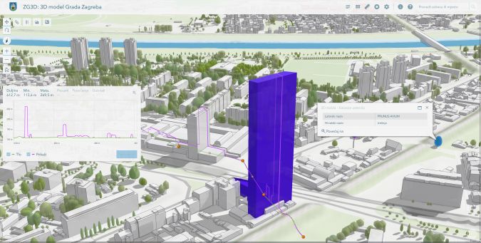
In 2016, a web app called ZG3D was produced and presented for browsing, viewing and using 3D data. Provided by geo-IT company GDi Ltd Zagreb and based on Esri technology, ZG3D integrates 3D data on existing buildings with 3D and 2D data layers from the fields of urbanism, architecture, topography, geotechnics, public green spaces, heritage protection, urban renewal and statistics. The aim of the project is to develop a 3D city model for use in the municipal administration, education, science, economy, civil society and other applications. The application allows users to view layers and basemaps, customize the display of data, select objects, take 3D and 2D measurements, analyse visibility, create cross-sections, display shadows and search addresses (Figure 1). The latest version of the ZG3D application was released in December 2021. The custom JavaScript web application was built with ArcGIS API for JavaScript 4.x. It supports core location-based functionality such as basemap layers, geocoding and elevation services. ArcGIS data hosting services are used to access data in the cloud such as feature and image tile services.
Use of the 3D model in city planning
Zagreb city planners successfully adopted digital spatial technologies in 2D form during the 1990s and 2000s, both in producing spatial plans and presenting them to the wider public. The next step in city planning in the information age is 3D urban planning. A precondition for 3D planning is the existence of a 3D city model, appropriate planning tools and qualified planning staff. The application of the 3D city model in spatial planning by the city of Zagreb so far can be summarized as:
- 3D overlay in master land use planning
- 3D building zoning in detailed land use planning
- 3D modelling of new buildings during architectural competitions
- 3D modelling of building interpolations in the protected heart of the city.
Master and detailed urban planning
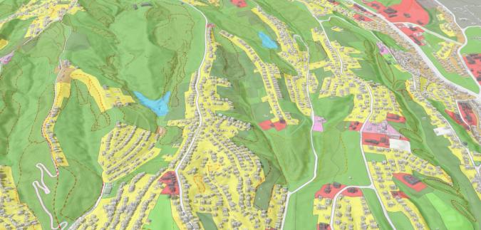
In master land use planning, overlay with a 3D city model is one of the basic ways of visualizing the world ‘virtually’ for urban planning and development. This overlay allows planners to check proposed building regulations with the existing local situation and align them better with existing building heights and volumes, for instance. The combination of a land use map and DTM can also be useful in urban planning for hilly and mountainous areas, enabling terrain limitations and landslides to be considered (Figure 2).
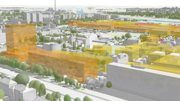
When it comes to detailed urban planning, the 3D city model becomes an indispensable tool for evaluating existing buildings and for designing and presenting building regulations to the general public. 3D building outlines can be presented to the local population and the city administration as volumes showing the possible future dimensions of buildings in a 3D environment (Figure 3).
Architectural competitions and interpolations
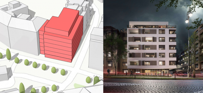
Architects were one of the first users of 3D data, especially to show the impact of planned buildings on the surroundings. In the past, such visualizations were made by approximating the heights and shapes of buildings, without an accurate spatial reference. 3D models of cities have now given architects those missing features, along with the ability to integrate the intended designs with all other spatial data. After the introduction of ZG3D, Zagreb architects began to use it for analytical and visualization purposes in architectural competitions and for the design of building interpolations in the city centre (Figure 4). This approach enables the creation of better and more accurate spatial solutions and generally more informed decision-making in urban planning.
Although many improvements have been made in the last decade, there are still a number of challenges in applying 3D city models in the day-to-day work of planners and architects. Some of the issues that need to be addressed in the future are the standardization of urban planning and architectural data, education and training of planning and architecture experts, and finding a sustainable model for updating the data.

Towards a digital twin of Zagreb
As a digital representation of an urban area, a 3D city model provides a fundamental building block for digital twins. Adopting a smart city approach, with 3D city models as the basis, provides huge economic benefits to cities, especially in city planning and urban design. The city of Zagreb intends to upgrade its existing 3D city model and the ZG3D application into a digital twin of the city. At the moment, there are two main issues: 1) upgrading and updating 3D building data, and 2) integrating live information about urban processes and activities within the 3D model of the city. The current plan includes to improve and update the 3D model using data from the official Lidar survey conducted for the entire territory of the Republic of Croatia in 2022.
After the model has been updated, the city is considering a new process for further updates, linked to the process of usage permits for new buildings. As far as live data sources are concerned, numerous smart city projects are underway, including in transport, waste management and environmental monitoring. The future digital twin of Zagreb will serve as the basic infrastructure for further development of the smart city strategy.
Conclusions
As the basic building blocks for digital twins and smart cities, 3D city models provide huge economic benefits to towns and cities, especially in town planning and urban design. Using interactive 3D platforms, architects and planners can better understand new building designs in context, assess their impact and restrictions, anticipate urban developments and communicate findings to stakeholders in a very intuitive way.
The city of Zagreb started developing a 3D city model back in 2008. The model has been improved and updated over the years in accordance with new technologies. The model is now used in the city for many different purposes. It is also available openly for citizens through the ZG3D web app. Although it is already very useful for various purposes, in order to become a real digital twin the model must be upgraded to a higher level of detail and must be updated on a more regular basis. Only then can it support a smart city strategy.
Implementing 3D city model into the day-to-day work of planners and architects is a slow process, but can be achieved with the necessary collaboration, investment and capacity building. The results in Zagreb so far show that the use of a 3D city model in spatial planning can help to achieve better solutions in master planning, detailed urban planning and the development of architectural projects. As the model is further improved and integrated with real-life data, the positive impact on city planning and management is expected to become even greater.

Value staying current with geomatics?
Stay on the map with our expertly curated newsletters.
We provide educational insights, industry updates, and inspiring stories to help you learn, grow, and reach your full potential in your field. Don't miss out - subscribe today and ensure you're always informed, educated, and inspired.
Choose your newsletter(s)


