Standardizing Remote Sensing Data Collection at FEMA
During a disastrous event such as a major hurricane, wildfire, catastrophic flooding or a destructive earthquake, first responders must quickly understand the magnitude and the nature of the event and its impacts upon citizens and communities. Remotely sensed data can be crucial for preliminary awareness about the scope of such a disaster. That is why the USA’s Federal Emergency Management Agency (FEMA) has implemented a tool called the Area of Interest (AOI) Tasker to automatically identify and prioritize areas that require collection of satellite and aerial imagery. It was used for the first time during the 2018 hurricane and wildfire seasons.
Timely and accurate intelligence about the scope of a disastrous event are key for effective and successful response decisions, such as deployment of resources and aid, rescue operations and containment of hazards. However, the damage and destruction caused by the very nature of such events often hinder the ability to assess the impacts on the ground. Power outages limit communication with survivors, while damaged roads prevent search and rescue teams from rapidly accessing the affected areas. It is during these events that remotely sensed data becomes crucial for preliminary awareness about the scope. In order to optimize the value of remotely sensed data for response and recovery following disasters, the collection operation must be properly planned and implemented. Decisions regarding when and where to collect the imagery, which imagery to collect and who will collect it are all key for a successful data collection plan. National, regional and local stakeholders often have different needs and requirements for intelligence, while overlapping requirements may cause duplicative collection efforts and parallel requests for tasking.
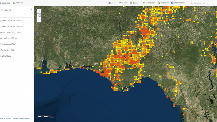
The USA’s Federal Emergency Management Agency (FEMA) relies heavily on remotely sensed data to support emergency management partners and to coordinate between varying needs and priorities. To ensure a flow of relevant and timely imagery before, during and after a disaster, FEMA must accurately plan and prioritize the areas requiring collection. To address this need for a systematic method of prioritizing the collection of remotely sensed data, New Light Technologies developed a tool called the Area of Interest (AOI) Tasker. It is designed to automatically identify and prioritize areas that require collection of satellite and aerial imagery, utilizing the United States National Grid System (USNG) – a standardized geographic division commonly used for disaster response operations. The tool was implemented at FEMA during the 2018 hurricane and wildfire seasons.
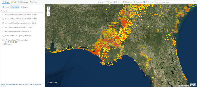
The tool is based on the assumption that collection of imagery and intelligence should be prioritized in those areas that are predicted to be hit or severely damaged and where vulnerable populations are most likely to be affected. Likelihood of exposure and damage is determined based on various predictive analytical models, including flood depth grids, surge and wind probabilities or wildfire extents. To estimate an event’s impacts upon communities, these models are intersected with residential parcel data comprising locations of structures. Additional demographic characteristics collected by the U.S. Census Bureau of Statistics are used to identify where vulnerable populations are located. These characteristics are disaggregated from the administrative system to the USNG spatial division and include, for example, the number of elderly people, unemployment rate, number of people with public assistance or on food stamps and number of mobile housing units. A weighted risk/exposure rank, which accounts for both hazard probability and demographic characteristics, is calculated for each USNG division (cell) and is translated into a relative collection priority. High collection priority is given to those cells with the highest probability of being damaged and where vulnerable communities are located.
FEMA uses the tool to guide and prioritize daily collection requirements, which are then shared among the disaster response community as an ArcGIS map service. According to Chris Vaughan, geospatial information officer at FEMA, the AOI Tasker provides a unified collection plan that is openly shared across public and private entities thanks to its open and transparent nature. The tool ensures timely collection of imagery, better allocation of resources and a rapid understanding about the impacts of a disaster.

Value staying current with geomatics?
Stay on the map with our expertly curated newsletters.
We provide educational insights, industry updates, and inspiring stories to help you learn, grow, and reach your full potential in your field. Don't miss out - subscribe today and ensure you're always informed, educated, and inspired.
Choose your newsletter(s)


