Surveying in the Valley of the Temples
Use of Full-waveform TLS in 3D Modelling of an Unstable Area
Full-waveform terrestrial laser scanning enables high-precision 3D topographic modelling of unstable rock valleys that is valuable for various geomorphological investigations. The area below the archaeological site of Temple of Juno in Agrigento, Sicily, is characterised by the presence of large sections of rock that have fallen down from the upper ridge. In this context, full-waveform laser scanning technology was tested for the production of a highly detailed 3D topographic model at two resolutions (2cm and 20cm) for simulating potential rockfall paths at the site.
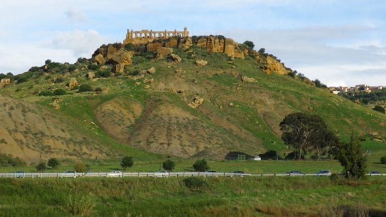
Along a long ridge outside the city of Agrigento, Sicily, is a UNESCO World Heritage Site, the Valley of the Temples, containing significant archaeological structures including the Temple of Juno (an area of about 16,000 square meters with a difference in height of about 150 meters). This area has a long history of problems related to geological instability. Being precariously close to the edge of the upper ridge (about 2-3 meters away from the temple columns), the instability is clearly deduced by the presence of medium-to-large-sized fallen blocks along the margins of the archaeological site (Figure 1).
Long-range terrestrial laser scanning (TLS) for 3D topographic modelling has become one of the most effective and rapid techniques for geomorphological and geotechnical analysis of unstable rock areas. It facilitates the identification of the morphological features of rock structures (such as discontinuity orientations, fractures and roughness) as well as the precise size and position of rock elements, providing the basis for the simulation of potential rockfall paths. This is critical for the monitoring of landslides and rockfalls, and leads to estimates of deformations and movements in multi-temporal sequences, supported by the sharing of data on GIS platforms.
However, TLS involves a number of application challenges such as occlusion, shaded areas, the maximum attainable resolution and surface roughness. In the digital reconstruction phase, the accurate removal of vegetation (and other noise) by point classification is also critical for generating a detailed reconstruction of slope geometry and individual blocks of rock. In this case, the ability of TLS to filter vegetation was improved by exploiting full-waveform technology when surveying a large slope below the Temple of Juno. Such devices are able to provide multiple return echoes, allowing an automatic segmentation of points and hence facilitating more accurate 3D modelling.
TLS Survey
Full-waveform technology allows a pulse-detection post-processing method to be applied to the digitised backscattered signal, where a theoretically infinite number of echoes can be identified, with respect to a single emitted signal. Multi-target detection helps to separate points belonging to the soil (or continuous surfaces) from points belonging to vegetation with some limitations regarding the minimum distance between two nearby targets, usually referred as multi-target resolution (MTR). The use of full-waveform TLS offers numerous advantages, including the ability to obtain a more reliable DTM and more detailed surfaces.
The survey was carried out using a Riegl VZ-400 time-of-flight full-waveform terrestrial laser scanner (Figure 2), capable of a maximum range of 600m with a maximum resolution of 5mm at a distance of 100m. To ensure complete coverage and a detailed reconstruction of the site, 17 scans from 14 different positions were performed directly within the area so as to avoid such occlusion by larger blocks of rock, with resolutions ranging from 2cm to 10cm at a distance of 100m (Figure 3). Some targets were placed in order to align and merge all of the scans. A GNSS survey of the targets was carried out in RTK mode to georeference the final model in the UTM-ETRF2000 reference system.
From Point to Object
The processing workflow was characterised by a sequence of operations with an initial phase of registration, georeferencing, filtering and merging of each scan. A precise methodology was followed in order to obtain more morphological detail on particular elements, such as the blocks of rock and the upper ridge. During the online full-waveform analysis and point classification produced by the laser scanner, the total number of points was reduced down to about 60% (i.e. to 72 million points).
The filtered and merged dataset was sub-set by semi-automatic classification and manual selection into one group of points belonging to blocks of rock, another relative to the ridge and a third group belonging to the slope. A geometrical model decomposed into subsets was deemed to be the most useful for extracting appropriate metric information.
All subsets were individually re-sampled according to a spatial octree procedure and then triangulated: for the first two groups (rock blocks and ridge) various meshes were created with a resolution of 2cm, while for the slope a DTM with a resolution of 20cm was produced. In the final step, the comprehensive 3D model of the site was obtained through the relocation of the sub-models (blocks and upper ridge) within the DTM of the slope (Figure 4). In the resulting model it is possible to individually select various object groups to facilitate the automatic extraction of metric information (distances and volumes) and the generation of geometric elements (contour lines, vertical and horizontal sections).
During the modelling phase a number of problems were encountered relating to the exact morphological representation of the site, both in the lower part of the blocks of rock, where it was impossible to acquire useful data, and in a few areas with abundant vegetation covering the upper ridge. Further difficulties were encountered during the editing process, which placed high demands on the processing time for certain operations.
Rock Geometry
The extraction of useful data depends on the quality of the generated model, which must by necessity have a high degree of accuracy. The reliability of geometric information also depends on the possibility to identify particular groups of points or geometric entities (such as polylines) through partial segmentation based on geometric parameters. This can usefully be adopted in CAD programs for the discrete analysis of geometric elements and their interactions (Figure 5).
For the examined case, the detailed reconstruction of the blocks of rock enabled the determination of volume and position of each individual block with respect to the upper ridge. The individual volumes, albeit relating only to the outcropping parts, are considerable in estimating the volume of the original ridge, on the basis of an empirical law describing the behaviour of fallen and removable blocks and considering the geotechnical properties of the materials involved in the rock fragmentation process.
The overall model also serves as a base for the extraction of geometric primitives, such as contour lines and vertical sections, used to check and analyse the spatial distribution of the blocks of rock or evaluating the distances between them and the ridge. Furthermore, individual block selection allows partial analysis of the rockfall development along one predetermined direction.
Potential of Full-waveform TLS
The high acquisition capacity of full-waveform TLS has proven satisfactory in terms of generating a high-precision 3D topographic model in this case, and is particularly efficient where features such as vegetation, artificial and natural obstacles can limit the possibility to measure points belonging to the terrain or rock surface. While a full-waveform TLS is quite satisfactory in terms of point classification, the quality of the obtained results must be interpreted and evaluated with respect to the acquisition range, together with the laser footprint size, which depends on the angular resolution of the instrument. Indeed, for the production of valid high-resolution 3D models, a high degree of certainty in point-to-object classification is critical.
In this project, a 3D reconstruction of a slope below the Temple of Juno was divided into three parts with different resolutions, according to the level of detail required for blocks, ridge and terrain. The ability to calculate the volumes of individual elements and to extract any section along different directions allowed an interpretation of rock-block detachment dynamics and an estimation of the original volume of the upper ridge. Further studies and investigations may be carried out regarding the development of interactive models, where metric information will be directly connected to the various display scales and to the maximum resolutions associated with the individual elements. Such a multi-scale, multi-resolution approach represents a key factor that can be extensively applied to other cases.
Acknowledgements
The authors would like to thank Microgeo s.r.l. (Italy) for providing the Riegl VZ-400 laser scanner and the Riegl Riscan Pro software. A special thanks to the Ente Parco Archeologico e Paesaggistico della Valle dei Templi in Agrigento.
The authors
Fabio Di Salvo is an architect and PhD candidate in geomatics at the University of Palermo, Italy. He is co-author of articles concerning the applications of terrestrial laser scanners for 3D reconstruction of cultural heritage and geological environments.
E-mail: fabiodisalvo@alice.it
Mauro Lo Brutto is assistant professor in geomatics at the University of Palermo, Italy. He obtained his PhD in geodetic and topographic sciences at the Parthenope University of Naples in 2001 and has carried out several studies on photogrammetry, laser scanning, GNSS and high-resolution satellite imagery.
E-mail: mauro.lobrutto@unipa.it

Value staying current with geomatics?
Stay on the map with our expertly curated newsletters.
We provide educational insights, industry updates, and inspiring stories to help you learn, grow, and reach your full potential in your field. Don't miss out - subscribe today and ensure you're always informed, educated, and inspired.
Choose your newsletter(s)


