Taiwanese Lidar Project
Getting Prepared for Flooding
Nearly three-quarters of the territory of Taiwan and 95% of its population are exposed to frequent natural hazard. In the aftermath of typhoon Morakot that scourged Southern Taiwan on 8th and 9th August 2009, causing the worst flooding in a century, the authorities realised that the country was dreadfully lacking in detailed, accurate and current elevation data, as well as aerial imagery covering the entire territory (36,000km2). In response, a national mapping programme spanning 2010 to 2015 was launched with the aim of simultaneously capturing the entire country by airborne Lidar and digital imagery. The authors discuss specifications, status and challenges posed by this large-scale, long-term project.
Understanding of a country's geomorphological and geological conditions is essential for combating and responding to flood disaster. In the years 2005 to 2007, geologists mapped active faults, volcanic and other geological features of northern Taiwan using a Digital Elevation Model (DEM) extracted from airborne Lidar point-clouds. The success of this mapping project triggered the Central Geological Survey Taiwan (CGS) to initiate a national programme for disaster mapping based on airborne Lidar and aerial photogrammetry in the aftermath of the Morakot disaster in 2009.
Special Statute
Over a 24-hour period, tropical typhoon Morakot dumped 211cm of rain - in some areas in excess of 300cm - on a 10,000 km2 area of southern Taiwan; that is more than a quarter of the country's territory. The resulting landslides numbered 40,594, and tons of soil from nearly 350km2 of land slithered into 145 streams, as could be documented from Taiwan's Formost-2 satellite imagery. In response to the Morakot disaster the government initiated a temporary law, or ‘Special Statute for reconstruction of post-typhoon Morakot disaster', which prompted CGS to initiate a dedicated project aimed at the conservation of land in zones sensitive to flooding due to geomorphological and geological conditions.
The project is employing airborne Lidar to establish a new nationwide DEM, grid size 1m, for hazard analysis and assessment. The special statute remains in effect for a period of three years, from 31st August 2009 to 30th September 2012. However, it will be impossible to cover the entire territory of Taiwan within this short time-span. This means those areas not surveyed under the Special Statute will be captured in a second phase lasting from 2013 to 2015.
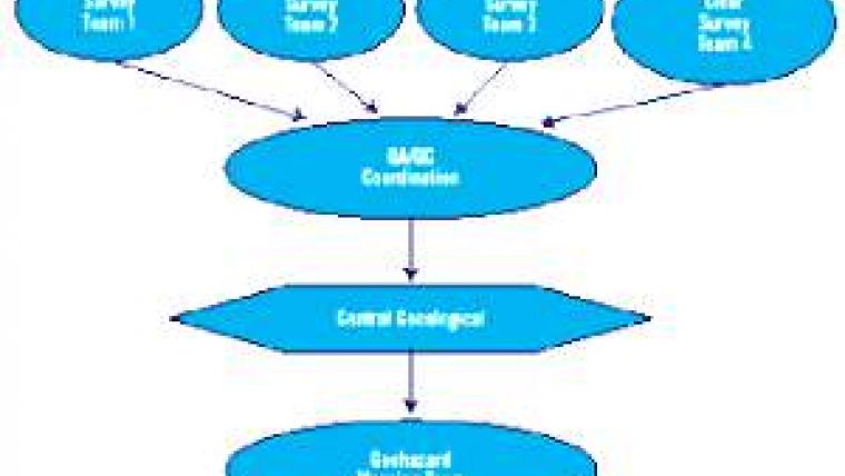
Mapping Scheme
The mapping programme consists of three major steps (Figure 1, above):
- execution of actual airborne Lidar and digital imagery survey
- third-party quality assurance (QA) of the Lidar DEM
- Mapping zones, which are sensitive to hazards, from the Lidar DEMs.
The programme is subdivided into six individual projects. Simultaneous airborne Lidar and imaging survey is being conducted by four survey teams operating a variety of laser-sensor systems including Leica ALS60, Optech ALTM Pegasus, and Riegl Q680i. QA has been assigned to a team headed by a professor specialised in surveying. The third step, mapping, consists of extracting from (1) the Lidar DEM, (2) aerial images and (3) ancillary information geological structures, riverbed landform change, river terraces and river channels, landslide features, and zones highly vulnerable to landslides. Furthermore, selected areas near mountain settlements are being mapped in greater detail and assessed for their vulnerability to landslides. The mapping is carried out by six teams, each headed by a professor specialised in geology. Each team maps the areas most familiar to them.
Phasing and Products
The survey plan is based on the tiles of the 1:5,000 national map series, each covering an area of around 2.5 x 2.8 = 7 km2 (Figure 2). During the first phase, lasting less than three years (2010- 2012), the Morakot disaster area covering 3,451 tiles (24,410 km2) has to be completed. During the second phase the remaining part of the country, covering 1,903 tiles (13,321 km2), has to be completely surveyed, also within three years. The area to be captured in the first phase is subdivided into ten survey blocks. One of the survey teams captures the coastal-zone block. The other three teams have to collect data on land areas each measuring around 2,500km2. Point density should be at least two points per m2 for areas below 800m and at least 1.5 points per m2 for areas higher than 800m above sea level. From the medium-format digital aerial images taken during the airborne survey, orthoimages with a ground sample distance (GSD) of 0.5m have to be generated.
Challenges
Weather is the primary challenge when carrying out aerial survey. Taiwan is located in tropical and subtropical zones, so for most of the year the sky is cloudy. Cloudy conditions are either unsuitable for executing aerial survey or impose too many requirements, as cloud-occluded areas have to be re-flown at a later stage. To give an impression of cloud-free time-spans, from 2007 to 2009 an average of thirty hours flight time per month were available. Steep slopes also pose a challenge in a country where 70% of the territory consists of mountains and hills; 32% of the land area lies above 1,000m and 25% between 500m and 1,000m, while the area above 200m is mainly covered by tropical and sub-tropical forest. As a result, Multiple Pulses in Aire (MPiA) mode cannot be applied to yield a higher point density, and consecutive flight lines have to lie close together.
Open-minded
Coordination is essential when executing such a long-term and complex project in which many contractors, who are also competitors in the global commercial marketplace have to cooperate to bring the endeavour to a successful conclusion. For example, when gaps exist between adjacent survey blocks captured by survey teams from different firms, any mismatch has to be solved in consultation with other teams without claims or quarrels. Third-party checking of acquired data is not meant to point an accusing finger, but should be aimed at bringing the parties together and stimulating the creation of solutions. Flaws found during quality check or criticism should be expressed in a constructive and open-minded atmosphere. The party responsible for quality control and coordination should thus provide a platform for sharing experiences while convincing all parties involved that they have a mutual obligation to go for the best. One outcome of good cooperation is that the experience gained can be translated into adjustment of survey parameters in order to optimise data quality and accelerate the survey.
Concluding Remarks
The Lidar DEM, orthoimagery and other geo-datasets resulting from the programme will become an important part of the national spatial data infrastructure of Taiwan in all the phases of disaster management cycle, from preparedness to response and recovery.

Value staying current with geomatics?
Stay on the map with our expertly curated newsletters.
We provide educational insights, industry updates, and inspiring stories to help you learn, grow, and reach your full potential in your field. Don't miss out - subscribe today and ensure you're always informed, educated, and inspired.
Choose your newsletter(s)


