Tandem for 3D Corridor Mapping
Simultaneous Geo-data Capture from the Ground and from the Air
3D mapping of roads, pipelines and other linear structures – often called corridors – is an important geomatics activity. Geodata acquisition technologies, which are increasingly used for corridor mapping and also for 3D mapping of urban areas, are mobile mapping systems and unmanned airborne systems. Can these two technologies be combined for simultaneously capturing corridors from the ground and from the air to improve efficiency, completeness and accuracy? This was the leading question in the mapKITE project. In this article, the authors explain the concepts underlying the project and prove their feasibility through pilot studies.
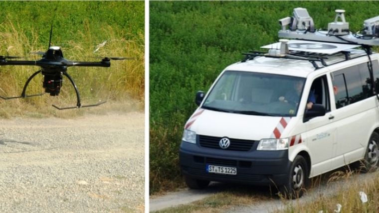
MapKITE – developed within the Horizon2020 R&D programme of the European Commission – integrates an Unmanned Aerial System (UAS) and a Mobile Mapping System (MMS) for simultaneous capture of geo-data from the air and from the ground (Figure 1). The UAS consists of a Spyro-4 quadcopter from UAVision equipped with a Sony NEX-5R camera with 20mm camera constant and a high-precision GNSS receiver. The MMS consists of a van equipped with dual-Lidar Lynx from Optech, operated by TopScan GmbH. The UAS is operated and controlled from a ground control station (GCS) onboard of the MMS.
Tandem
To enable the UAS and MMS to operate in tandem a number of innovations had to be developed and implemented. One of the keys of the concept consists of the ‘virtual tether’ software which runs on the GCS installed in the MMS. Based on the 3D coordinates generated by the real-time navigation system of the MMS, UAS waypoints are computed and next transmitted to the UAS (Figure 2). In this way the virtual tether forces the UAS to follow the MMS allowing the operation in tandem. The UAS is always in line-of-sight of the MMS. Another key concept is the use of Kinematic Ground Control Points (KGCPs). The implementation of the KGCP concept consists of a target mounted on the rooftop of the van (Figure 3). The target is designed such that it can be automatically identified and accurately located in the UAS images. KGCPs enable tremendous reduction in placing and measuring of GCPs in the field or even eliminates the need for these, which saves a lot of time and costs, especially in corridor surveys, and speeds-up the workflow. The target also acts as an additional tracking facility, which adds to safety when the computation or transmission of waypoints fails. The target and the real-time target-tracking facility were designed by EPFL.
Test
Ten teams from six countries have been working on developing, constructing and validating the first prototype since March 2015. In June 2016, several test surveys were conducted at the BCN Drone Centre in Moià, Barcelona, Spain. This UAS testing facility covers 2,500 hectares of segregated airspace. A non-paved road through a rural landscape was captured over a length of 2.3km. The height of the UAS varied from 80 to 90m above ground resulting in a ground sampling distance (GSD) of 2cm. The images were captured with an along-track overlap of 80% yielding a base-to-height ratio of 0.156. This guarantees good geometric precision and robustness even when there are gusts of wind or large terrain variations. As the test aimed at validation of components rather than on testing performance under full operational condition, the survey was conducted at low speed, ranging from 10 to 30 km/h. The next section focuses on the accuracy assessment of the test.
Accuracy
To assess the potential of KGCPs as input in the triangulation and geo-referencing of the images, 37 GCPs were evenly distributed along the corridor. To simulate a conventional UAS corridor survey a one-way strip consisting of 149 images was selected. Using tie points, the GNSS coordinates of the UAS trajectory and 19 evenly distributed GCPs the interior and exterior orientation parameters of the 149 images were calculated. The same images were also geo-referenced using 136 KGCPs complemented with two GCPs at each end of the strip, i.e. four GCPs in total. Figure 4 shows the distribution of GCPs and KGCPs over the test area. Using the remaining part of the GCPs, 18 in total, as checkpoints, the accuracy of both the conventional UAS survey and the mapKITE survey have been calculated. The accuracy statistics show that the accuracy of the mapKITE survey slightly outperforms the conventional UAS survey (Table 1). The accuracy of the conventional approach can be improved at the cost of adding GCPs. So, the mapKITE concept enables corridor surveys at a lower cost while maintaining high accuracy standards.
|
|
Conventional UAS Survey |
mapKITE Survey |
||||
|
East [mm] |
North [mm] |
Height [mm] |
East [mm] |
North [mm] |
Height [mm] |
|
|
Max |
164 |
110 |
245 |
103 |
76 |
212 |
|
Min |
-59 |
-71 |
-103 |
-4 |
-64 |
-122 |
|
Mean |
3 |
14 |
31 |
0 |
-5 |
7 |
|
Std. Dev |
49 |
48 |
87 |
32 |
36 |
86 |
|
RMS |
49 |
50 |
92 |
32 |
36 |
87 |
|
RMS (px) |
2.46 |
2.52 |
4.61 |
1.61 |
1.82 |
4.33 |
Table 1, Accuracy statistics obtained from confronting the computed coordinates of check points with the reference values.
Business Opportunities
MapKITE focuses on corridor mapping, which appears to be a growth market. Indeed, there is an increasing demand for 3D mapping of roads, railways and waterways; inspection of powerlines and oil and gas pipelines; and coastal monitoring. Geo-data simultaneously collected from ground and airborne viewpoints complement each other. Roofs not visible in an MMS dataset and occluded objects are captured from an airborne perspective (Figure 5). Line-of-sight limitations between GCS and UAS usually dictated by regulations disappear within the mapKITE concept as it is kept continuously within standard specifications. Of course, there are constraints on the survey duration particularly introduced by the need to change batteries and the limitations of UAS speed, which is lower than for MMS.
Future
The navigation systems onboard the UAS and MMS collect redundant data, the capability of which is not yet fully exploited. Although the MMS navigation system is more accurate than the UAS system, data from the latter may be beneficially exploited in case of blocking or multipath of GNSS signals. Also here the target mounted on the van plays a key role. Laser scanners, digital cameras and other sensors continue to become smaller and lighter, which enables their combined use in one and the same UAS. The UAS developments concern fixed-wings with Vertical Take-Off and Landing (VTOL) capability, operation in swarms and longer battery charge endurance. Together with global regulations relief these developments will trigger more efficient and robust UAS operations. When EU’s Galileo and the Chinese Beidou GNSS become fully deployed, around 100 GNSS satellites will be available by 2020. With new wideband signals, improved multipath mitigation and more precise code-based ranging the precision of the KGCPs will steadily increase supporting the feasibility of our approach.
Concluding Remarks
Now our concept has proven its feasibility, we are working on making it operational for corridor mapping by cooperating with system integrators and survey companies who aim to extend their portfolios. The concept and prototype were presented at a workshop held in June 2016. The event was attended by the world’s leading mapping service companies and technology integrators. On the MapKITE concept GeoNumerics holds patents in Spain (ES2394540) and United States (14/417,435) while patents are pending in Europe and Brazil.
More information
Molina, P., Blázquez, M., Cucci, D.A., Colomina, I. (2016) First Results of a Tandem Terrestrial-Unmanned Aerial mapKITE System with Kinematic Ground Control Points for Corridor Mapping.
Remote Sensing 9 (1), 60.
Video: https://vimeo.com/181634599

Value staying current with geomatics?
Stay on the map with our expertly curated newsletters.
We provide educational insights, industry updates, and inspiring stories to help you learn, grow, and reach your full potential in your field. Don't miss out - subscribe today and ensure you're always informed, educated, and inspired.
Choose your newsletter(s)


