Teledyne Optech Lidar Enables Discovery of Extensive Mayan Ruins
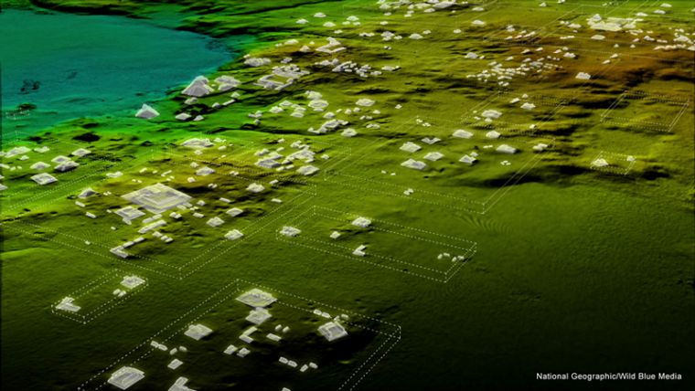
Teledyne Optech’s Titan sensor was used by the University of Houston’s National Center for Airborne Laser Mapping (NCALM), USA, to reveal extensive Mayan ruins in Guatemala. Lidar technology was able to identify hundreds of previously unknown structures, including raised highways and complex irrigation and terracing systems.
After the collapse of the Mayan civilisation, their cities and monuments were quickly covered by thick rainforest, hiding the ancient civilisation from airborne observation and making it very difficult to survey on foot. Flying high above the rainforest, Titan’s lasers penetrated the canopy to collect almost a million data points per second from the forest floor, giving archaeologists a “bare earth” view of the structures underneath. Having rapidly covered 2,100 km2, Titan’s data revealed massive amounts of ruins hidden below the forest, showing that their urban centres were significantly larger than archaeologists had previously thought.
More discoveries expected
Michel Stanier, EVP and general manager of Teledyne Optech, said his company is incredibly proud and excited that the award-winning Titan multispectral Lidar sensor has contributed to this spectacular discovery. Titan’s ability to strip away overlying vegetation and map wide areas very quickly and accurately makes it an important tool for archaeologists. Stanier added he expects to see many more discoveries coming from it and our other airborne laser terrain mappers.
Optech Titan is the first commercial multispectral Lidar sensor to incorporate 3 independent laser wavelengths into a single sensor design, with beams at 532, 1064, and 1550 nm (0.5/1.0/1.5 microns) and a ground sampling rate of 300 kHz per beam. Because Titan uses both green and infrared channels, it is capable of simultaneous water depth mapping and high-precision 900-kHz topography. Titan can also be used for purposes such as vegetative and forestry applications, which require multiple wavelengths for improved classification accuracy and carbon credit counting initiatives.

Value staying current with geomatics?
Stay on the map with our expertly curated newsletters.
We provide educational insights, industry updates, and inspiring stories to help you learn, grow, and reach your full potential in your field. Don't miss out - subscribe today and ensure you're always informed, educated, and inspired.
Choose your newsletter(s)


