The Benefits of Visual Intelligence Solutions in Agriculture and Forestry
Digital Twins in Farming
Visual intelligence solutions for agriculture and forestry provide easy access to digital maps of fields, forests or plantations. In turn, this opens a world of opportunities, including the ability to take measurements ranging from phenotype microplot traits to forest inventory. Additionally, users can identify early signs of stress in large plantations, generate precise, ready-to-use weed control maps, and follow the evolution of the assets over time. This article illustrates how digital twins optimize the workflows for key agriculture and forestry activities based on real-world applications.
Thanks to new visual data management platforms, generating digital twins of agricultural assets has never been easier. It empowers seed companies, universities, research institutes and agrochemical companies around the world to develop varieties that are better adapted to future climates and more respectful of the environment. In forestry and plantation management, as well as in precision agriculture, digital twins can be used to drive actionable business insights and reduce operational costs, as these real-world customer stories by Delair show.
Phenotyping Operations
Digitalization technologies empower companies with enhanced capacities to understand crop behaviour in a given environment, leading to the launch of products and solutions that are better tailored to the end-user needs. New-generation unmanned aerial systems (UASs or ‘drones’) and other new sensors associated with sophisticated imagery analytics are revolutionizing plant science research and the entire agriculture industry by providing plant-based phenotyping data, and therefore a better understanding of how seeds perform in the field.
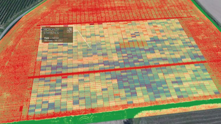
Various analytics applied to the digital twins of experimental fields can be used to measure traits throughout the crop season with centimetre precision, such as estimating the number of plants, measuring plant health and plant height, characterizing flowering, extracting ripening velocity or mapping the fraction of ground covered by green vegetation (FCover).
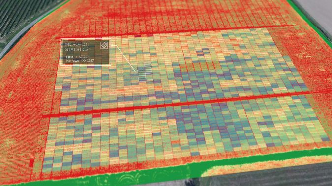
Data Standardization of Field-based Research Programmes
When visualized and managed in the cloud, digital twins provide easy access to data, anytime and anywhere. Such collaboration around digital twins helps research companies to streamline and standardize their drone-based field studies and, ultimately, further accelerate their programmes to develop new solutions for the agriculture market.
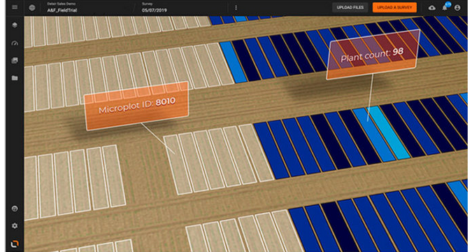
Each year, BASF conducts several thousands of research trials in agricultural stations throughout the globe to measure product performance under different field and climate conditions. The company recently introduced drones equipped with multispectral sensors to automate and optimize field data collection, allowing real-time insights into how plants respond to environmental conditions. Thanks to a recent agreement signed with Delair, BASF is now able to build digital twins of its research fields, as well as map and analyse hectares of plots across all trial sites. The cloud platform enables field agronomists to automatically vectorize as well as georeference microplots and generate biological data and crop behaviour per plot. Delair’s visual intelligence platform will give BASF access to a standardized and centralized system to manage its drone-based research projects globally. “As a research-driven agricultural company, we want to use the full potential of digitalization to accelerate innovation. Partnering with Delair will help us to get a deeper understanding of the observed crops and their surrounding environments, and reduce the time to market for new products,” said Greta de Both, manager of sensor-based field phenotyping for seeds & traits at BASF.
Forestry Inventory
Knowing and regularly monitoring the characteristics of a forestland is key to managing it effectively and responsibly. With visual data management solutions, it has never been easier to build and update the digital twin of a forest and, from that digital copy, to optimize every stage of timberland ownership. This includes mapping and GIS analysis, forest management planning, inventory and harvest scheduling, or timber stock monitoring. From an environmental standpoint, the forest’s digital model plays an important role in understanding and monitoring the impact of drought and diseases on trees. On the digital twin of a forestland, it is for example even more efficient to run a health diagnosis by locating dead trees and areas of concern, or to get an early warning of diseases with a combination of satellite (macro views) and drone data (detailed diagnosis). With this type of insight, it is easier to mitigate risks and plan your replantation operations. In addition, automated timber quantity measurements, such as forest biomass, cut or fallen timber, also make the digital twin a very effective tool for estimating and valuing the carbon balance of a forestland.

In France, a collaboration between Delair and Forestry, a forestland management and consulting firm affiliated with F&W Forestry Services Inc., demonstrated that it is now possible to map and assess more than 300ha (700 acres) of the Ventadour Forest Group in a few hours, with a 50% increase in productivity in the overall assessment of the forest characteristics.
Plantation Management
The challenges are pretty similar for plantation management. Digital twins of a plantation improve both productivity and sustainable management of crops, and help plantation managers to react quickly to sanitary issues.
Scouting maps, tree count and plant height are just some of the key indicators that can be extracted from a digital model. The digital twins also provide frequent, unintrusive and detailed inventory of the plantation, both at the field and individual tree levels. Early warning of stresses or disease through the scout analytics unlock new ways of running field operations and help to optimize inputs such as water, fertilizer and chemicals.
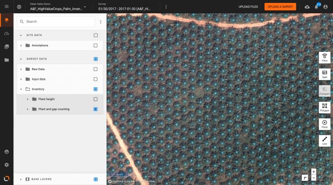
One area that has already seen a significant impact is palm oil and rubber tree plantations in Africa and in Asia. Visual data and digital plantation models provide proof of compliance with regulations, while collecting valuable crop information at the same time.
“The delair.ai platform offers a simple yet powerful solution to process the aerial images collected by drones. The agriculture-specific algorithms have automatically generated online-sharable maps and data from images captured in the field. The solution contributes to help Michelin improve the sustainable management of natural rubber throughout the value chain,” said Gregory Lesturgez, agronomist at the Michelin Plantation Department.
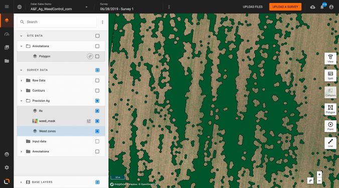
Precision Agriculture and Weed Control
In a context of environmental awareness, strict regulations and high input costs, new precision agriculture technologies are much needed. Thanks to digital twins of their fields, farmers can now apply herbicide only where weeds grow, resulting in input efficiency and environmental compliance.
The process is quick and simple once the data has been collected by drones equipped with a multispectral camera. Weed control or fertilizer prescription maps can be automatically generated from the digital model of a field, and transferred to a sprayer terminal for modulation rate application. Recent tests in corn fields showed that herbicide quantities can be reduced by up to 50%, which leads to a cost reduction of about 30% (including drone flight and prescription map generation).
Thanks to a partnership with John Deere, prescription maps generated on delair.ai are automatically exported to myJohndeere.com, a web portal connecting machines, fields and operators, and transferred to the sprayers.

Value staying current with geomatics?
Stay on the map with our expertly curated newsletters.
We provide educational insights, industry updates, and inspiring stories to help you learn, grow, and reach your full potential in your field. Don't miss out - subscribe today and ensure you're always informed, educated, and inspired.
Choose your newsletter(s)


