The Need to Integrate BIM and Geoinformation
Building Information Modelling: Essentials and Issues
In the construction industry, business relationships are often short term and one-off. There are many unique processes and activities. The resulting complexity and fragmentation may obstruct quick and effective exchange and integration of information and thus hamper project progress. Building information modelling (BIM) is aimed at preventing mismatches in information exchange between the many stakeholders. Although BIM has come a long way in this respect, there are still challenges to overcome.
The authors explain the essentials of BIM and discuss issues.
(By Sisi Zlatanova, The Netherlands, and Umit Isikdag, Turkey)
Building Information Modelling (BIM) evolved from supporting the design and construction of facilities, such as buildings, bridges and tunnels, to a research area in domains ranging from construction to urban planning and management. In parts of Europe, North America and southern Asia, BIM-based design and construction has been legally enforced. In the UK, for example, since 2016 public-sector projects require BIM for representing, sharing and exchanging information.
BIM
NBIMS (2006) defines BIM as “a digital representation of physical and functional characteristics of a single building. As such, it serves as a shared knowledge resource for information about a building forming a reliable basis for decisions, during its lifecycle from inception onwards”. BIM does not apply abstractions or simplifications of building components to reduce data volume; all components are represented with their true 3D shape. Therefore, all volumetric and parametric base components contain the smallest possible details. The location of a smaller component in a larger one, such as a window in a wall, is also indicated. Such base components serve manufacturing of, for example, prefabricated parts of walls including doors and windows. The information consists of dimensions, material type and much more. For example, a window may be characterised by the number of glass layers, thickness, colour, thermal transmittance and lamination. Windows and other building components may be extracted from BIM through semantic selection (Figure 1). Utility elements, such as gas pipelines, are also contained in the building information model. Companies manufacturing the components often play a role in the design. Stakeholders can collaborate across the life cycle of a facility and perform create/read/update/delete (CRUD) operations. Stakeholders can include designers, manufacturers of building elements, constructors, facility managers and software developers of applications. The terminology and data needs of each stakeholder differ and standards have been developed to avoid the need to remodel the same facility for different stakeholders.
IFC
Sharing information across organisations, departments, IT systems and databases requires standardisation on semantics, geometry and topology. Such standards have been developed since the mid-1990s and one widely accepted standard is Industry Foundation Classes (IFC). IFC facilitates the cost-effective sharing of information without becoming dependent on file formats, which are product- or vendor-specific. IFC is semantics-rich and object-oriented. The latter means that each component can be uniquely identified regardless of its size. IFC is also truly 3D in which all geometries are topologically valid solids with no daggling edges or unclosed polygons. The hierarchical maintaining of spatial relationships ensures correct ‘inclusion’ and ‘part of‘ relationships. IFC is also data-rich and thus enables a comprehensive, detailed description of all physical and functional features of a facility. These characteristics of IFC allow for quick selection and query of parts of the facility as well as creation of views of the facility to serve stakeholders.
Information Management
Information management can be done by either the transitional approach or the central-database approach. In the transitional approach, a building is represented as a loosely coupled collection of sub-models, each providing a portion or a stage of the BIM; the representation can either provide a part of the whole model, such as two of the four stories of a building, or a stage of the whole model, such as the scheduled construction in the first two weeks. Next, these sub-models are aggregated in a single, shared BIM. In the central-database approach the building model is stored on one server, which allows users to query and immediately see any component and its properties or any design revision made. Both approaches have benefits. The first approach allows stakeholders to exchange their sub-models or domain-specific model parts during design and construction, specifically when the workload is divided between many short-term contracts; a subcontractor can work independently of others without needing a detailed view of the entire project. The second approach suits maintenance and facility management in which the changes are less critical and a general view is more important.
Facility Management
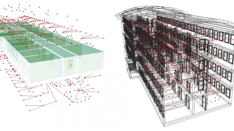
Once the facility is erected, in use or in operation, BIM offers many advantages for monitoring and maintenance. For example, doors and windows overdue for maintenance can be identified; walls, slabs, stairs and elevator shafts can be analysed for necessary repair or replacement work. Air conditioning systems or other new components can be ordered precisely tailored and the associated detailed information can be brought into the BIM immediately. A central-database approach facilitates quick, easy and reliable updating. BIM also facilitates the automatic generation of models for supporting indoor navigation and positioning. From these models, connectivity networks can be generated for computing an optimal path from a present location to a desired location (Figure 2).
Integration
In the design stage, a BIM represents a forthcoming reality through detailed geometry also representing the internals of objects. The BIM is not yet connected to a location represented in XYZ coordinates. In contrast, geoinformation describes the reality of the broader area around the projected location of the new facility through XYZ coordinates. GIS models apply abstractions and simplifications, which leads to relatively fewer objects, details and properties compared to BIM. While IFC provides an easy determination of ‘inside’ relationships, GIS models are oriented towards neighbourhood relationships. Added to this, objects in GIS models are derived and interpreted from data captured from cameras or laser sensors resulting in representations in the form of bounding surfaces, while the internals of the objects are only modelled if required as this is labour intensive and thus costly. City model standards such as CityGML also provide more detailed interior representations such as LOD4 but these are not as detailed as in IFC. For example, a wall in CityGML is only the surface of the wall, while IFC would describe the 3D solid of the entire wall. Hence, one physical wall in IFC would be represented by two surfaces in CityGML. The value of integrating BIM information and geoinformation becomes apparent in ‘BIM Execution Planning’, which formalises the design, construction and maintenance activities of a facility. ‘Site Planning’ together with ‘Design Authoring’ and ‘Cost Estimation’ are BIM uses and these define a series of tasks related to the intended use of the facility. The construction industry appreciates the benefits of BIM uses but seems to underestimate the value of BIM information integrated with geoinformation. To respond to all stakeholders’ demands, BIM is expanding towards integrating information from the surroundings stored in a GIS, as has been carried out in a large study conducted in Rotterdam, The Netherlands (Figure 3).
Conversion
As IFC contains more detailed and more complex information than CityGML, the conversion from IFC to CityGML is relatively straightforward and stable. However, the other way around requires additional rules and information resulting in complex and as yet unsolved problems. These issues have triggered academic research on seamless conversions, producing the recommendation to follow first semantics mapping and then geometry and relationship transformations – but further in-depth investigations are still much required.
Metadata and Big Data
The spatial data infrastructure (SDI) provides a framework for organising and managing spatial data and its associated metadata. In contrast, BIM is a data and information model without accompanying metadata, although the value of metadata is slowly penetrating the construction industry. Recently, discussions on the role of BIM as a part of big data started to emerge via international networking platform LinkedIn. This is encouraging since BIMs will remain unconnected, isolated islands of information as long as there is a lack of awareness about their role in the bigger picture of GIS and big data.
Concluding Remarks
The role of BIM will continue to grow but, besides the opportunities, there are many challenges. Once the challenges and issues have been identified, they will have to be discussed with the GIS communities to increase awareness and develop solutions.
Authors
Sisi Zlatanova holds a PhD from Graz University of Technology, Austria. Her research focuses on 3D modelling, integration of BIM/IFC and 3D GIS, 3D topology, spatial DBMS and augmented and virtual reality. She is president of ISPRS Commission IV Spatial Information Science (2016-2020) and has authored/co-authored over 300 scientific papers and edited/co-edited 20 books.
s.zlatanova@tudelft.nl
Umit Isikdag holds a PhD from the University of Salford, UK. His research focuses on BIM/IFC, 3D GIS, Internet of Things, RESTful Architectures and Spatial Web Services. He is involved in organising 3D GeoInfo and GeoAdvances Conferences and is a member of ISPRS WG IV/1.
uisikdag@gmail.com
Figure 1, Example of a semantic selection of windows from a building information model.
Figure 2, Automatically generated connectivity networks.
Figure 3, Integration of a newly designed quay (BIM) with surrounding existing objects stored in a GIS.
Further Reading
NBIMS (2006) National BIM Standard Purpose, US National Institute of Building Sciences Facilities Information Council, BIM Committee. https://www.wbdg.org/pdfs/NBIMSv1_p1.pdf
https://www.linkedin.com/pulse/bim-data-isnt-big-discuss-andy-hamer?published=t

Value staying current with geomatics?
Stay on the map with our expertly curated newsletters.
We provide educational insights, industry updates, and inspiring stories to help you learn, grow, and reach your full potential in your field. Don't miss out - subscribe today and ensure you're always informed, educated, and inspired.
Choose your newsletter(s)


