The Rapidly Changing Way We Visualise Our Environment
Observations from the Eye of the Geospatial Hurricane
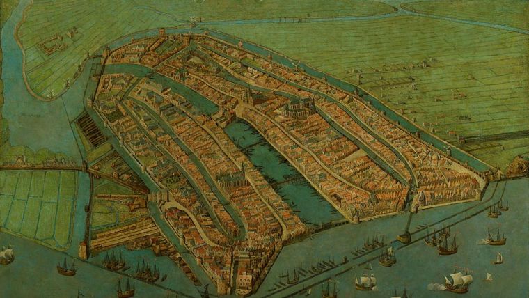
The geospatial industry is expanding rapidly. New and pioneering players are entering the market, and new technologies are finding their way into the mapping and surveying profession. People have been visually capturing their surroundings ever since the earliest days of mankind – from cave paintings dating back many thousands of years, to the Ancient Egyptians and the artworks of the Dutch Masters. And the concept of mapping the environment has been around for many centuries too, on both a large and small scale and even in 3D. Back in the sixteenth and seventeenth centuries, surveyors and cartographers were true craftsmen. With breathtaking skill and precision, they were able to produce bird’s-eye views that combined a 2D map with perspective views of buildings. A lot has changed since then. Digitalisation has arrived on the scene, triggering a revolution in mapping.
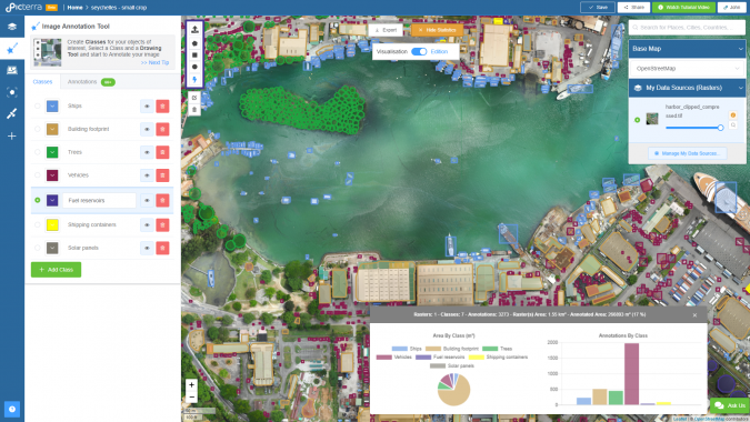
Point clouds are now being used to make amazingly detailed 3D models of complete cities. Nobody has a crystal ball, of course, but we could probably spend hours if not days discussing what the near future – and, perhaps even more intriguingly, the slightly more distant future – has in store in terms of surveying and mapping. Which techniques and solutions are available to us today? Which professionals are already using them, and who soon will be? Which knowledge and skills are required? And which major transformations lie ahead?
The geospatial industry – like many other sectors – is in the midst of a major transition as the digitalisation of manufacturing is drastically changing the way products are produced. This phenomenon is commonly referred to as ‘Industry 4.0’, because it can be seen as the fourth revolution that has occurred in manufacturing. This revolution has increasingly gained pace over the past couple of years, and previously mind-boggling digital solutions have entered not only the manufacturing industry but also the geomatics field. Artificial intelligence (AI), machine learning, big (dynamic) data, augmented reality (AR), virtual reality (VR) and the Internet of Things (IoT) are all adding new dimensions to the mapping and surveying profession. Sir Francis Bacon, the famous English philosopher and ‘father of empiricism’, stated: “He that will not apply new remedies must expect new evils; for time is the greatest innovator”. If we apply this to the geospatial industry, we could argue that companies who manage to be frontrunners in integrating these technologies into their solutions may very well become the leaders in the Industry 4.0 era.
All these disruptors are causing considerable turbulence in our industry, creating in effect a geospatial hurricane. The latest edition of Intergeo, the world’s leading trade fair for geomatics – which was held from 16 to 18 October 2018 in Frankfurt, Germany – could be regarded as being at the eye of this hurricane, and its attendees were able to see for themselves how the geospatial wind of change is driving some interesting and exciting technological developments. The hurricane is good-natured for now but, to ensure that they emerge from the storm unscathed, manufacturers of geospatial solutions should implement the technological game changers – ranging from AI to VR – into their products.
To many of the people involved in geodata-related fields, the digital transformation may still seem a little abstract. They may have heard much of the digitalisation-related terminology, but as yet they only have a vague idea of how all the new technologies can be applied in practice. In other words, how will the likes of AI, big data, AR, VR and so on help us to visualise the world around us in a couple of years’ time? Probably still with breathtaking skill and precision, although now in a fully automated way – so without the craftsmen who captured the environment back in the days of the Dutch Masters. We will be able to create real-time digital twins that enable us to analyse the data we need on the fly. But while today’s technology has surpassed the capabilities of the Ancient Egyptians or famous Dutch artists such as Jacob van Ruysdael, Aelbert Cuyp and Johannes Vermeer, it is definitely still worth going to admire their amazing artefacts and paintings on display in museums around the world. And remember: the storm isn’t over yet!

Value staying current with geomatics?
Stay on the map with our expertly curated newsletters.
We provide educational insights, industry updates, and inspiring stories to help you learn, grow, and reach your full potential in your field. Don't miss out - subscribe today and ensure you're always informed, educated, and inspired.
Choose your newsletter(s)


