The SDGs Indicator Framework: A Golden Opportunity
A Golden Opportunity for the Geospatial Information Community
As anyone cognisant of the UN’s work will have noticed, since 25 September 2015 every policymaker involved with international development has been excited by the 2030 Agenda for Sustainable Development – a 15-year road map. In this article Mr Amor Laaribi, a geospatial information expert from Tunisia, looks at the 2030 Agenda through the geospatial information lens, highlighting the opportunities to raise awareness and understanding of the fact that geospatial information is fundamental to supporting sustainable development.
(By Amor Laaribi, geospatial information expert, Tunisia)
By way of background, it is worth noting that, unlike the Millennium Development Goals (MDGs, from 2000-2015), which were limited in terms of scope (eight goals) and coverage (dedicated to developing countries) and were devised by a small UN team, the 2030 Agenda (from 2016-2030) is the result of global consultation, covers all development challenges (17 goals, 169 targets, 230 indicators) and involves all stakeholders: public and private sectors as well as civil society. More significantly, the 2030 Agenda builds on the progress made under the MDGs, taking into account the lessons learned from their implementation and including the shortfalls – the chief one of which is the ‘data gap’.
The recognition of data’s importance, as outlined in the SDSN report titled ‘Data for Development’, has put it at the centre of the implementation and monitoring of the Sustainable Development Goals (SDGs). The geospatial community is well aware that GIS is a data-centric system and geospatial data constitutes its most costly component, accounting for up to 70% of the total cost. It is incumbent on the geospatial community to capitalise on its established experience with data and make the case that geospatial data/Earth observations constitute a large part of big data, hence putting geospatial information at the core of the data revolution.
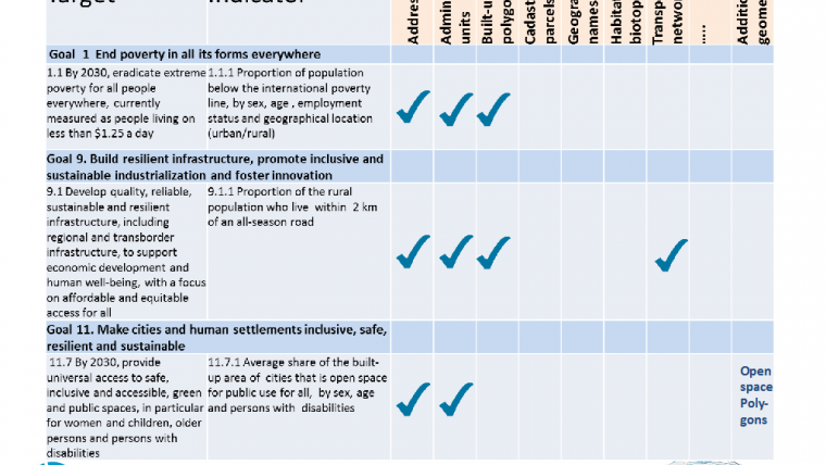
The 17 Sustainable Development Goals were set by politicians, but the means of measuring and monitoring their achievements, reflected by the SDGs Indicator Framework which encompasses some 230 indicators, were defined by statisticians. The SDGs Indicator Framework is a one-time opportunity for the geospatial community to catch up and be involved at the implementation level, cooperating with statisticians and other stakeholders. As stated in the Terms of Reference of the UN Working Group on Geospatial Information of the Inter-Agency and Expert Group on SDG Indicators, geospatial specialists should particularly contribute to the data disaggregation of the indicators where the geographic dimension (location, urban/rural, region, etc.) is required, and not leave it to others to define geography through their own lenses.
The SDGs call for cooperation and partnership; the 17th goal stresses the importance of partnerships between the various groups, as well between nations and UN agencies. They constitute a golden opportunity for the geospatial community to connect with policymakers on the benefits of using and understanding data geospatially and building geospatial infrastructures, and to ‘educate’ project managers who are mainly economists or development specialists with limited geospatial background.
Amor Laaribi
Mr Amor Laaribi has over 30 years of experience working in the field of geospatial information for decision-making and development. He joined the United Nations Statistics Division Office in February 2000 to define and plan the priorities of the UN in the geospatial information area and to promote its use with census mapping in developing countries. He contributed to the foundation of the United Nations Committee of Experts on Global Geospatial Information Management (UN-GGIM) and led the work of the UN Expert Group on the Integration of Statistical and Geospatial Information in support of the 2030 Agenda.
amorlaaribi7@gmail.com
Further Reading
- SDSN report on ‘Data for Development: A Needs Assessment for SDG Monitoring and Statistical Capacity Development’, 17 April 2015 (http://unsdsn.org/wp-content/uploads/2015/04/Data-for-Development-Full-Report.pdf)
- The Terms of Reference of the UN Working Group on Geospatial Information of the Inter-Agency and Expert Group on Sustainable Development Goal Indicators (https://unstats.un.org/sdgs/files/Working-Group-ToR--GeoSpatial

Value staying current with geomatics?
Stay on the map with our expertly curated newsletters.
We provide educational insights, industry updates, and inspiring stories to help you learn, grow, and reach your full potential in your field. Don't miss out - subscribe today and ensure you're always informed, educated, and inspired.
Choose your newsletter(s)


