Topographic mapping for snow avalanche hazard modelling
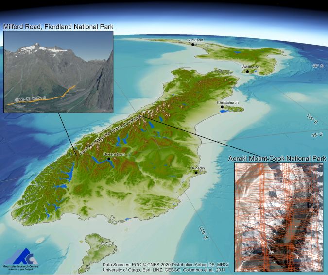
The use of innovations in satellite photogrammetry and Lidar in New Zealand
A project in Aotearoa/New Zealand is combining the use of high-quality DEMs from satellite photogrammetric mapping (SPM) with Lidar technologies to model hazards such as snow avalanches. The resulting topographic mapping can improve planning and preparedness to deal with mass movements of snow and debris in alpine regions.
Mass movements such as snow avalanches and debris flows pose risks to people and infrastructure in alpine regions around the world. These hazards can be simulated with advanced modelling software to support decision-making and risk mitigation, which requires accurate high-resolution digital elevation models (DEMs) to make results meaningful. Advances in satellite photogrammetric mapping (SPM) are bringing high-quality DEMs to many alpine regions previously lacking modern digital topography. At the same time, Lidar technologies are used to calibrate hazard models and offer rapid-response capacity to quantify the impact from hazards such as snow avalanches. Ongoing research in Aotearoa/New Zealand is highlighting the importance of topographic mapping in snow avalanche planning and preparedness.
Mapping technologies
The development of open-source tools like NASA’s Ames Stereo Pipeline (Beyer et al., 2018) has greatly improved satellite photogrammetric mapping (SPM) workflows. Ongoing research at the Mountain Research Centre (MRC) aims to automate the SPM workflow to produce high-resolution digital elevation models (DEMs) accurate to the image ground sample distance, without the need for ground control surveys. The MRC is developing tools to automate 3D-change detection with repeat mapping for landscape monitoring and mapping hazards like snow and rock avalanches with an increasing range of satellite constellations including Pléiades (PHR, Neo), Worldview and SkySat. For example, a 2m DSM produced from 0.5m Pléiades PHR stereoimagery has been used to quantify snow depth distributions (Eberhard et al., 2021). Next-generation sensor constellations such as the 0.3m Pléiades Neo reduces revisit time, thus improving the level of detection and accuracy achieved by SPM.
of challenging topography in a single acquisition. It is now efficiently complemented by very-high-resolution (VHR) mapping technologies operating closer to the ground. Terrestrial laser scanning (TLS) and UAV-Lidar are used for resolving fine detail in extreme terrain, as well as for rapid deployment to document natural hazards. Used together, advances in topographic mapping are enabling hazard researchers to gain both new insights into the sensitivity of hazard models to topographic representation, and unprecedented validation data for the modelling.
Topographic representation in avalanche modelling
Dynamic hazard models like Rapid Mass Movement Simulation (RAMMS) simulate mass movements such as snow avalanches on real terrain, represented by a DEM. The hazard model outputs help prepare for extreme events and assist in the design of mitigation structures such as berms to decrease the risk to people and infrastructure from avalanches. For example, models are used for hazard indication mapping and the design specifications for buildings and roads sited in areas at risk from a 100-year or 300-year avalanche event. The dynamic hazard models are sensitive to the accuracy and resolution of the underlying DEM. Artefacts from DEM production and interpolation, or from outdated topography, can lead to consequential errors in the hazard model outputs. At the same time, higher-resolution DEMs (e.g. 1 or 2m) capture higher surface roughness compared with their low-resolution counterparts, which affects how avalanche flow is simulated over the same terrain.
Subtle differences between DEMs due to sensor technology and mapping technique can also impact hazard modelling. For instance, the use of a digital surface model (DSM) versus a digital terrain model (DTM) may introduce additional surface roughness in the model when the terrain includes significant vegetation. Also, when mapping steep terrain, the orientation to the sensor impacts on derivative topographic representation and accuracy. Larger base-to-height ratios in SPM will improve precision, but at the expense of an increased probability in terrain obstruction. Terrestrial scanning can resolve extremely steep terrain, but multiple scans may be needed to mitigate obstructions. Unmanned aerial vehicle (UAV or ‘drone’) platforms can help fill the gaps between satellite and terrestrial topographic mapping.
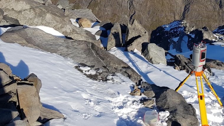
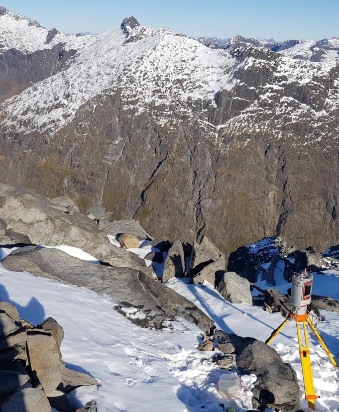
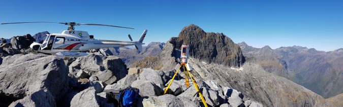
Terrestrial Lidar and avalanches in Fiordland
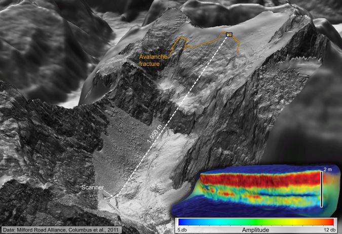
A team of dedicated avalanche mitigation specialists manage snow avalanches hazards on Milford Road in Fiordland, New Zealand, using a variety of tools, including a network of alpine weather stations, HD webcams and a RIEGL VZ-6000 ultra-long-range scanner (Figures 2 and 3). The scanner is used to produce a snow-free DEM of avalanche terrain in summer as well as repeat mapping in winter to estimate snow depths. The scanner is also used for documenting avalanche paths after an event to calibrate the RAMMS avalanche model.
The scanner’s range provides a detailed view of the snow released in an avalanche, as well as the snow left behind. For example, technicians used the Lidar intensity in the near-infrared range to characterize the snow layering in the crown wall left after an avalanche released in the McPherson path in 2020 (Figure 4) from up to 2km away, thus providing valuable snowpack data used in the modelling. The pulse density, averaging 468 points/m2, resolved intricate layers in the snowpack and enabled the fracture height to be measured from a safe distance.
The scanner is also used alongside SPM to generate DEMs for hazard modelling. A composite of 24 scans totalling three billion points was used to generate a 0.5m DSM over 5km2. Recent research (Miller et al., 2022) characterizes how subtle differences in the terrain representation in the McPherson avalanche path between the TLS and SPM DSMs govern the way the hazard model replicated the real avalanche, with implications for how hazard modellers select the appropriate DEM for given terrain. Figure 4 depicts a 0.5m hillshade from the TLS on top of the previously best-available DEM for the area (15m). The avalanche in 2020 was released with explosives from a helicopter to mitigate the hazard to the highway. The modelling suggested over 70,000 tonnes of snow would be released within three seconds and would travel at velocities of over 200km/h, going airborne over a cliff and stopping short of the highway. Accurate high-resolution topographic mapping was required to model the physics of the large avalanche flowing in extreme terrain.
UAV-Lidar and avalanches in a national park
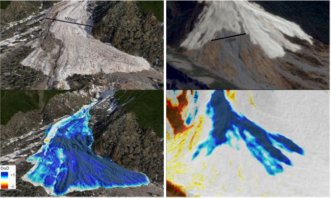
The use of UAVs to map avalanches provides a new level of detail in estimating debris volumes. These estimates are used to replicate the real event with a computer simulation. Once calibrated, modelled scenarios (i.e. What if the avalanche was larger? What if a powder cloud was generated?) can assist planners to mitigate the risks posed by future avalanches. Both SPM and UAV-Lidar surveys provide DEM of Difference maps (DoDs) and volume estimates for avalanche debris.
A widespread avalanche cycle in New Zealand’s Aoraki Mount Cook National Park in July 2022 generated some of the largest avalanches observed in the park in decades. A UAV survey commissioned by the Department of Conservation mapped the debris from a large snow avalanche close to Mt Cook Village where a berm was recently constructed to divert avalanches away from roads and buildings. A DJI Matrice 300 series UAV, with real-time kinematic (RTK) positioning and DJI L1 Lidar sensor, mapped 35ha with 531 points/m2. The 0.5m DSM was differenced with a 2m SPM DSM derived from Pléiades PHR to estimate the volume of avalanche debris (175,860 ±11,386m3), which was used to calibrate the RAMMS model and assist in the assessment of the risk posed to the village by future avalanches. Figure 5 shows orthoimages and example DoDs from two avalanche events in Aoraki Mount Cook National Park, as measured by UAV-Lidar in July 2022 and SPM – a 2m DSM generated from 0.5m SkySat imagery in October 2021. The UAV-Lidar point cloud can be efficiently and interactively visualized thanks to webGL platforms such as Potree.
Conclusion
Innovations in satellite photogrammetric mapping (SPM) enable high-resolution topographic mapping of challenging alpine terrain previously lacking such data. At the same time, advances in Lidar technologies from terrestrial scanners and UAVs are providing rapid-response capacity to map and document natural hazards in unprecedented detail. Snow avalanche modelling relies on high-quality DEMs to simulate events on real-world terrain, providing data used to mitigate the risks posed to people and infrastructure from large avalanches. Future improvements in accuracy, resolution, coverage and revisit capacity of topographic mapping technologies will provide improved planning and preparedness for mass-movement hazards in alpine regions.
Further reading
Beyer, R. A., Alexandrov, O., and McMichael, S.: The Ames Stereo Pipeline: NASA’s Open Source Software for Deriving and Processing Terrain Data, Earth Space Sci., 5, 537–548, https://doi.org/10.1029/2018ea000409, 2018.
Eberhard, L. A., Sirguey, P., Miller, A., Marty, M., Schindler, K., Stoffel, A., and Bühler, Y.: Intercomparison of photogrammetric platforms for spatially continuous snow depth mapping, The Cryosphere, 15, 69–94, https://doi.org/10.5194/tc-15-69-2021, 2021.
Miller, A., Sirguey, P., Morris, S., Bartelt, P., Cullen, N., Redpath, T., Thompson, K., and Bühler, Y.: The impact of terrain model source and resolution on snow avalanche modelling, Nat. Hazards Earth Syst. Sci., 22, 2673–2701, https://doi.org/10.5194/nhess-22-2673-2022, 2022.
WebGIS data for Fiordland: https://arcg.is/0fqHS4
The Kitchener avalanche: https://www.otago.ac.nz/surveying/potree/projects/20-001_Kitchener_avalanche.html

Value staying current with geomatics?
Stay on the map with our expertly curated newsletters.
We provide educational insights, industry updates, and inspiring stories to help you learn, grow, and reach your full potential in your field. Don't miss out - subscribe today and ensure you're always informed, educated, and inspired.
Choose your newsletter(s)


