
Towards Smaller and Smarter Solutions
Reflections on Intergeo 2019
Intergeo is a leading annual industry showcase where geospatial professionals gain an excellent impression of the latest innovations. On the brink of a new decade, Intergeo 2019 gave us a glimpse of the future. In general, we can conclude that solutions are getting smaller and smarter, and there are some new kids on the block. But with all the buzz around machine learning and artificial intelligence, how can we cut through the hype to get the most out of the rapidly advancing technology?
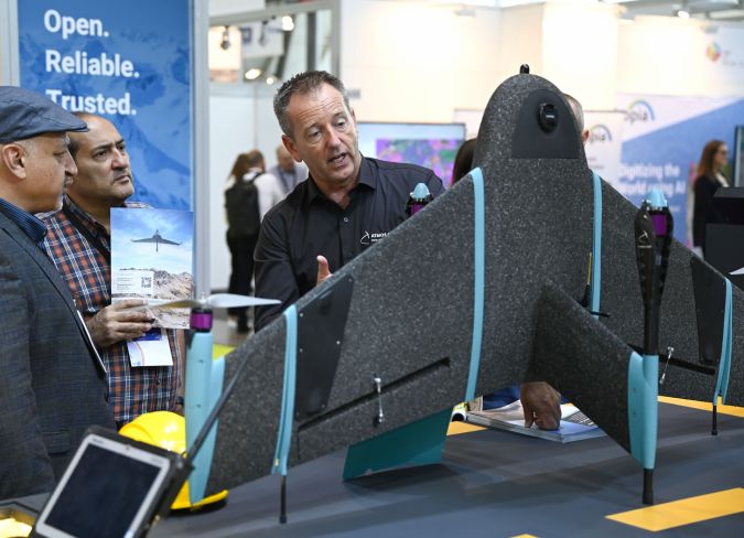
One thing was crystal clear at this year’s Intergeo: the unmanned aerial vehicle (UAV or ‘drone’) has well and truly moved beyond the hype. The unmanned aerial system (UAS) has now become a standard survey method which has proven its practical value for a multitude of applications. The annual geospatial gathering in Stuttgart revealed an increase in the number of hybrid UASs. Examples included the Marlyn autonomous vertical-takeoff-and-landing (VTOL) drone – developed by Atmos UAV – that combines the flexibility of a multirotor with the efficiency and speed of a fixed-wing, and a similar solution from Switzerland-based Wingtra, a spin-off company from the Autonomous Systems Lab at ETH Zurich.
Drones with laser scanners
The miniaturization of scanners combined with the increased payload capability of drones is leading to a rapid increase in drone-based laser scanners for point cloud capture, such as the new UAV scanner from RIEGL and the small Velodyne HDL-32E scanner. Determining the position and attitude of the scanner during the flight requires the inclusion of high-quality GNSS and IMU equipment. One such solution on display at Intergeo 2019 was from French company YellowScan, which showcased its turnkey 3D UAV-Lidar systems. Overall, drone-based Lidar is clearly making a serious impact for specialists across many professions.

Smaller mobile mapping systems
Around a decade ago, mobile mapping systems (MMSs) were the newest innovation in Intergeo’s vast exhibition halls, with lots of big systems comprising laser scanners, cameras and navigation equipment mounted on top of big vehicles. Today, the number of suppliers has declined to just a few companies. The mobile mapping systems are much harder to spot too, because they have become much smaller over the years. New, miniaturized sensor technology enables the sensors to be mounted on various types of moving platforms and opens up new possibilities for more versatile and less expensive MMSs. Most systems can now be lifted easily, allowing for hassle-free mounting and dismounting, and many are even portable.
Invasion of automotive sensors
Alongside traditional suppliers of land survey equipment, there was a notably higher number of suppliers with origins in automotive sensors. Thanks to the economies of scale resulting from their existing production activities, these suppliers are capable of delivering lower-cost sensors. Although they are not especially built for surveying, those sensors are suitable for use in situations where quality is not essential, such as visualization. Integration with centimetre-level GNSS and MEMS IMUs can turn laser scanners from the automotive industry into a mapping payload for UAVs.
Indoor mapping expands
Staying on the topic of sensors, there were also many new sensors for indoor mapping applications. The solutions, which included backpacks and a new handheld scanner from Leica Geosystems, typically work on the simultaneous localization and mapping (SLAM) principle. The development of SLAM algorithms has enabled the advancement of mobile laser scanning (MLS) to provide 3D data from GNSS-denied environments, such as indoor locations and industrial sites. Recent further improvements in SLAM technology and software tools mean that surveyors can use mobile devices for an ever-expanding range of applications. Moreover, the data can be automatically processed and visualized as intuitive HD maps or realistic, interactive digital twins, thus making it accessible for a broader customer base.
Photogrammetry revival
The continued rise, advancements and applications of Lidar as a prevalent geodata acquisition technology were visible at this year’s event, but visitors could still find plenty of photogrammetry on the exhibition floor. Thanks to significant improvements in both hardware and algorithms, dense image matching (DIM) – a computer vision-driven technology that allows for the generation of detailed and reliable point clouds from images – has led to a real revival of this field. At GIM International, we spotted the key role of DIM in many geoinformation-related innovations almost a decade ago, and the technology is now clearly allowing photogrammetry to step out of Lidar’s shadow.
Artificial intelligence – hype or hope?
On the topic of algorithms, artificial intelligence was hard to ignore at this year’s Intergeo. But are artificial intelligence (AI) and machine learning (ML) worth the hype, and should you be taking action now? Or is it better to wait and see how things pan out? In our view at GIM International, you should consider what AI and ML can actually add in your situation at the moment. Solutions that incorporate machine learning are not automatically better than those that do not. Having said that, machine learning already plays a role in many aspects of our daily lives. AI is already being applied in Lidar or photogrammetry imagery, for example, but it requires high-quality and accurate data… and the accuracy of algorithms can be a challenge. But ML and AI-based methods certainly hold considerable promise in terms of improving automatic object detection in point clouds in the future, for instance. One good example of how AI and machine learning can add value to mapping and surveying solutions is Harris Geospatial’s ENVI geospatial analytics software. Its deep learning module delivers image-driven insights and also helps to make deep learning more widely available to the industry.
A glimpse of the future
This year, GIM International organized a full-day track as part of the Intergeo conference on the final day of the event. The morning session, titled ‘Geomatics in the Next Decade’, gave a realistic yet enthralling glimpse of the geospatial future. As Esri celebrates its 50th anniversary in 2019, Lawrie Jordan, the company’s director of imagery and remote sensing, took the audience on a journey into the future of GIS, saying that a new view and a new vision is now emerging of GIS as the “Intelligent Nervous System” for our planet. During his keynote, Jordan provided insights into some of the latest software technology trends intersecting with this nervous system, including practical examples employing AI, ML, deep learning, real-time and predictive analytics, multi-temporal image cubes, etc. The future-oriented and often mind-boggling technology offers the potential for a wide range of concrete applications.
The afternoon session, titled ‘The Many Faces of Mobile Mapping’, covered advancements in mobile and aerial mapping. Gottfried Mandlburger (Vienna University of Technology) delivered an excellent update on recent developments in airborne Lidar, putting emphasis on hybrid multipurpose 3D data acquisition. Pere Molina (GeoNumerics,) pointed out how GNSS technology – as a central ingredient in the positioning mix – struggles to fuse the numerous available frequencies and constellations and still deliver error-free trajectories. In his presentation, Molina elaborated on the problem and potential approaches to its mitigation. GeoNumerics’ mapKITE solution works with an analogy to the conventional ground control points (GCPs) by simply taking advantage of its operation; as the UAS follows the terrestrial vehicle, the target is observed in all the images providing ready-to-use kinematic ground control points (KGCPs) for every image. This results in a high-accuracy, high-resolution surveying method.
Conclusion
Following three busy days of Intergeo, we can conclude that sensors are getting smaller and more sophisticated. Hybrid mapping methods are becoming increasingly mature and, as a consequence, mainstream. Although Lidar technology is omnipresent, the market seems to have rediscovered the benefits of photogrammetry thanks to the many possibilities of DIM. A significant number of the exhibitors in Stuttgart were new entrants to the geospatial industry from other sectors. Many companies that were eye-catching start-ups and innovators (or ‘disruptors’) five years ago have since been acquired by major players such as Trimble and Bentley. Last but not least, after 25 years of Intergeo, the geospatial industry now has a bright future ahead as it increasingly interacts with other industries and its solutions become ever-more mainstream.
Acknowledgements
The author would like to thank Mathias Lemmens, senior editor of GIM International, and Martin Kodde, consultant and director at Geodelta, for sharing their experiences after attending Intergeo 2019.


Value staying current with geomatics?
Stay on the map with our expertly curated newsletters.
We provide educational insights, industry updates, and inspiring stories to help you learn, grow, and reach your full potential in your field. Don't miss out - subscribe today and ensure you're always informed, educated, and inspired.
Choose your newsletter(s)


