Trapped
"We are Well, in the Shelter, the 33 of us"
The above message from the Chilian miners must now be one of the famous ever to have been scribbled on a scrap of paper. It flew around the world as news spread of the rescue bid to bring the men, trapped underground since 5th August, to the surface. The mission was accomplished on 13th October, amid scenes of general rejoicing shared around the world.
The note had been tied to a perforation drill used by rescuers to bore through to an area near an underground shelter where the miners took refuge after the collapse that occurred in a gold-and-copper mine in Copiapo, about 850 kilometres north of the capital, Santiago. According to some reports, rescuers had drilled repeatedly in an attempt to reach the shelter, but failed seven times, blaming the errors on the mining company's maps. At least some of the earlier probes were so close that the trapped miners heard them. They finally succeeded in reaching the shelter, some 700 metres below the surface and roughly 7 kilometres from the mine entrance, at the eighth attempt.
This distance to the entrance immediately illustrates the problems encountered by surveyors when mapping mines: there are very few or no control-points during traverse. GNSS systems do not work underground, and winding shafts mean very short sights. Azimuths are determined from time to time using north-seeking gyroscopes.
A ‘copy' of the mine is often projected on the surface in order to stake out the location for special drill-holes to provide electricity and so on for the working areas, thus avoiding extremely long underground cables, or for pumping water out of wet areas. These drill-holes can be used as control-points during deep traversing.
The problem is how to precisely drill a hole to a location 700 metres below the surface. This is why the drill collar contains several instruments capable of performing all kinds of measurements and sending the information to the surface. In the oil industry they call it Measurement While Drilling (MWD). MWD tools are capable, among other measurements, of taking directional surveys in real time. The tool uses accelerometers, inclinometers, magnetometers etc in order to measure the direction of drilling. Operators can correct the direction of the drill using this data.
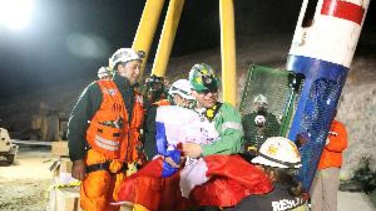
The photograph shows one of the miners being brought to the surface in the specially constructed capsule Phoenix after beiing trapped for almost 70 days; inset, the miners in their shelter. Further reading about MWD tools can be found on Wikipedia.

Value staying current with geomatics?
Stay on the map with our expertly curated newsletters.
We provide educational insights, industry updates, and inspiring stories to help you learn, grow, and reach your full potential in your field. Don't miss out - subscribe today and ensure you're always informed, educated, and inspired.
Choose your newsletter(s)


