Tunnel and Track Survey
Amberg Technologies
Amberg Technologies AG has been developing user-friendly system solutions for georeferenced data acquisition and processing in the field of infrastructure development for around thirty years. This Swiss company offers standardised products, customer-specific system solutions and project-specific services in the fields of railway surveying, tunnel surveying, tunnel inspections and tunnel seismics.
Amberg Technologies was established in 1981, from Amberg Engineering AG. Based in the Swiss Regensdorf-Watt, the company is owned by Felix Amberg and managed by Hans Peter Müller. The staff complement is eighty. The Amberg Group comprises Amberg Engineering AG, Amberg Technologies AG, and VSH VersuchsStollen Hagerbach AG and the various divisions deal respectively with tunnel systems, rail systems, geo-engineering and geophysics. Users of Amberg Tecnologies products and services number more than forty worldwide.
Tunnel Surveying
Modern tunnelling is subject to numerous demands. Tunnelling companies must keep down costs, finish projects in as short a time as possible and still maintain the highest quality standards. Amberg Technologies helps tunnel engineers meet these challenges by shortening preparation time, uncomplicated transfer of planning data, flexible operational capability of system solutions and the use of high-performance instruments. This all saves time, reduces downtimes in the tunnelling process and has a positive impact on project costs. The exactness of the measuring instruments provides a high level of set-out and profile precision.
The TMS Solution comprises different hardware and software modules, depending on the demands of a project. The hardware employed for tunnel surveying is the latest in scanner technology. The high-performance scanner Amberg Profiler 5003 and Leica total stations TPS1200, TS30 and TS15 combine high-speed measuring with maximum precision. The complete set of project and geometry data is available in the measuring station at all times, so that heading data can all be processed at the same time. Routine surveying is performed by the heading crew completely automatically.
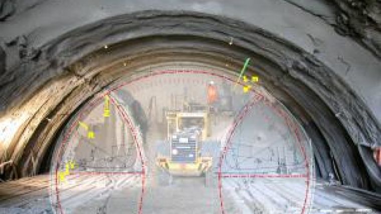
TMS Setout is the system solution for surveying in connection with axis-related set-outs. It supports automatic set-outs, for example, of banquettes, formwork-carriage positioning and elevation reference points.
TMS Setout Plus, however, supports heading control in tunnelling and enables the heading team to perform routine set-out work on its own. This means that surveying work can be done extremely quickly, and this means shorter onsite times for survey experts. The system can be employed flexibly on a mobile tripod or stationary console. Radio control makes possible set-out as a one-person operation. TMS Setout minimises waiting and downtimes and reduces costs in tunnelling due to the high-precision measurement results.
TMS Profile
TMS Profile is the specialised profile surveying solution for automatic 3D profile monitoring in tunnelling. The system measures individual profiles, making possible flexible, individual and parallel profile measurements, even directly during heading. As a result the user receives comprehensive profile documentation, including calculations of surface area and volume.
TMS Profile Plus, the expanded tool for profile surveying, delivers real-time results with the highest accuracy and visualises over and under break results. These advantages once again provide for shorter downtimes. TMS Profile Plus also allows performance of shaft analyses directly during heading.
The system calculates precise geometry data and seamless design vs. actual measurement comparison for profiles. The focused evaluation of measurement data contributes further to cost management in the construction process, and to account settlement.
Tunnel Scanning
TMS Tunnelscan offers comprehensive tunnel as-built documentation based on surface area registration. The mobile system with a modular structure consists of the acquisition and evaluation software for laser-scanner measurements and the Amberg Profiler 5003 high-performance scanner. The solution can document an entire tunnel structure geometrically and with imagery for every stage of construction. TMS Tunnelscan measures up to 10,000 times faster than conventional methods, even at the highest data densities.
Seamless profile monitoring, layer-thickness determination, surface quality monitoring, as well as true-to-scale image documentation of tunnel installations are among the outstanding advantages. In addition, the system provides information about the condition of structures and calculates detailed mass for optimised logistics and account settling.
Railway Surveying
Strict infrastructure data management is indispensable for the construction and maintenance of a reliable rail network. Precise surveying and comprehensive documentation allow the status of the track system to be continuously monitored both during the construction and ongoing maintenance activities.
The application-specific system solutions for use in the railway surveying field provide maximum efficiency in the construction and maintenance of track infrastructure. The primary fields include track geometry documentation, slab track surveying for track installation, tamping surveys for maintenance measures, inventory documentation and clearance profile surveying.
Amberg Rail consists on one side of the hardware, the GRP System FX surveying platform, and on the other a comprehensive software solution for railway surveying. In addition, the integrated quality management system, GRP Fidelity, enables our clients always to ensure their system is properly calibrated.
Logical and efficient management of survey data and their allocation to the appropriate track section are the focal points in railways surveying. Amberg Rail allows immediate, onsite use of the acquired survey data, as well as subsequent data processing. Today, Amberg Rail comprises four software applications: Amberg Slab Track, Amberg Tamping, Amberg Survey and Amberg Clearance.
Amberg Survey is the portable surveying solution for detailed geometry documentation of existing track systems. It allows for fast, precise and cost-efficient data collection of track geometry in support of planning and management of railway projects. Seamless data transfer facilitates uncomplicated analyses of the survey data for planning and design.
Slab Track
Amberg Slab Track detects minimal deviations from track design position using high-precision sensors. Real-time displays of deviations enable contractors to make quick and precise adjustments which substantially accelerate precision track installation. In addition to surveying, Amberg Slab Track also implements automatic data evaluation and documentation, including comprehensive geometry analyses for quality-control measures and project management. The system also facilitates significant productivity increases over conventional surveying methods.
Amberg Tamping is a system for tamping surveying in the construction and maintenance of ballast tracks, based on datum points. It also allows comprehensive track documentation. This mobile solution from Amberg Technologies records track position directly prior to actual maintenance work and automatically calculates the appropriate correction values. The system facilitates direct export of survey data to tamping machine and achieves a survey result three to four times better than classical methods.
Amberg Clearance
It is necessary for the safety and economy of a rail network to know the detailed, effective clearance profile around the tracks in addition to track positions. To meet these demands Amberg Clearance is a system solution for automated clearance profile surveying. Depending on specific information requirements, the user can inspect projecting objects individually using profile point surveying, or map the complete clearance profile using fully automatic 3D kinematic laser scanning. Clear result presentations allow visualisation and analyses of all restrictions.

Value staying current with geomatics?
Stay on the map with our expertly curated newsletters.
We provide educational insights, industry updates, and inspiring stories to help you learn, grow, and reach your full potential in your field. Don't miss out - subscribe today and ensure you're always informed, educated, and inspired.
Choose your newsletter(s)


