UAS Platforms: the Future of Successful Aerial Image Capture and Modelling
This article was originally published in Geomatics World.
UAS (Unmanned Airborne Systems) are rapidly becoming a valuable source of data for inspection, surveillance, mapping and 3D modelling projects. Investment in the commercial UAS industry - estimated to increase by US$3.5 billion by 2024 – reveals the potential for UAS to aid or replace traditional methods of data collection.
The catalyst for the high rate of UAS adoption is primarily the technological developments in microprocessor architecture and the falling costs of the manufacturing process. Even consumer-grade UAS - available for less than £1,000 – now feature sophisticated Internal Measurement Units (IMUs), GPS- and GLONASS-capable GNSS receivers, stabilised gimbals, and the ability to stream high-definition video in real-time.
Combined with numerous flight safety features, improved LiPo battery technology, and more user-friendly interfaces to the hardware and software, these small aerial platforms have been adopted by hobbyists, commercial enterprises, and researchers alike.
Current Platforms
Traditionally, fixed-wing UAS have generally been used for covering large areas, as they can stay in the air longer with a single battery than a multi-rotor drone (e.g. the Parrot Disco), which has a flight duration of approximately 55 minutes. However, as LiPo battery technology has improved, multi-rotor systems have rapidly caught up with longer flight durations as much as 40 mins. For various reasons, including ease of use, VTOL (Vertical Take-Off and Landing), and the capability to hover, multi-rotor systems have gradually gained a significantly larger market share than the more traditional fixed-wing platforms. In the future, this may of course change with the development of platforms that combine the advantages of fixed-wing (flight duration) and multi-rotor platforms (hover) (e.g. Wingtra).
Structure from Motion (SfM) Software
While some UAS applications – such as precision agriculture - use multi/hyper-spectral and LiDAR sensors, the majority of UAS data acquisition still uses RGB cameras. In parallel with the developments in UAS technology, Structure from Motion (SfM) photogrammetric software packages are now optimised to deal with RGB images acquired from UAS sensors. SfM offers a modern alternative to traditional photogrammetry that has rapidly become very popular with users of multi-rotor UAS. SfM software uses a new generation of image-matching algorithms to create 3D models by matching features on multiple images with algorithms that are based on a multi-view approach and can recognise many features throughout images.
Cloud-processing
SfM software is generally reliant upon computers with high-powered and expensive CPUs and GPUs. More recently, SfM software providers - such as Pix4D - have allowed users to upload geotagged images to their cloud-processing hub, removing the need for users to invest in high-powered PCs. The cloud interface allows the user to download the processed image formats and open the results in a variety of GIS packages to complete any further analysis.
Generating Custom Datasets
A range of products can now easily be derived from an SfM workflow allowing for numerous types of analysis, visualisation and communication. The flexibility of a UAS platform and sensor and the SfM software has empowered UAS users to collect and generate many different image and vector datasets with custom spatial and temporal resolutions specifically suited to an application.
Accuracy
Along with all the developments in platforms, sensors, batteries, hardware and software, high-resolution images can now be acquired to build accurate 3D models of the ground surface and features. For the UAS user, it is now possible to decide on the mission planning parameters required for data acquisition. Selection of the Ground Sampling Distance (GSD) (or the ground-based size of a pixel in an image) dictates the level of accuracy that can be achieved. Other parameters, including image overlap settings can be set depending on the type of terrain and image content required. Ground Control Points (GCPs) are currently needed because at present most UAS are still only equipped with single frequency GNSS receivers capable of achieving 2m rather than cm accuracies needed for surveying applications. An RTK GNSS is also needed to measure the centre point of GCPs to ensure high accuracy results. The availability of onboard RTK and PPK solutions for UAS platforms are now rapidly replacing the need for GCPs to be surveyed on the ground, and this will significantly enhance the surveying capabilities of the UAS platform.
Some Examples to Illustrate
Figures 2, 3 and 4 show three examples illustrating how low-cost UAS and GIS analysis can provide useful information for a variety of environmental applications such as archaeology, topographic surveying, and coastal management.
Archaeology
Very high-resolution ortho-imagery acquired using a low-cost UAS (e.g. DJI Phantom 3/ DJI Inspire 1) with ground resolutions of <5cm per pixel can be used to produce high-resolution ortho-images, DSMs and point clouds for large archaeological sites (>1 km2) to allow detailed site plans to be generated and the identification of field systems that cannot be seen from the ground. These would have been difficult to find using terrestrial laser scans, satellite imagery, or RGB imagery taken from manned aircraft. The benefits of acquiring imagery from a UAS are the low costs compared to commissioning traditional aerial photography and the significant amount of time needed to cover these areas with traditional ground surveying techniques. Low-cost UAS can fill a gap in the archaeological data capture workflow where large areas are required to be captured in very high detail in a short period of time. UAS-derived data can be analysed in GIS software to provide a record of site conditions that can easily be updated, as well as providing the opportunity to present findings in a visual form to help increase awareness and community involvement in highlighting the significance of archaeological sites.
Topographic Site Survey
A small building site was overflown with a standard off-the-shelf DJI Phantom 3 and camera system. A comparison was then made with a traditional GNSS RTK ground survey that was undertaken to determine if a low-cost multi-rotor UAS could meet 1:200 mapping accuracy standards set out by the UK’s Royal Institute of Chartered Surveyors (RICS) guidelines. In practice, the low-cost UAS could be used to complete the site survey to the same accuracy as the ground-based survey. The higher density of the data captured by the UAS survey also meant that the resulting DSM was much smoother, and the contour lines had more realistic geometries when compared to the contour lines of the interpolated TIN/Raster surface from the ground survey. Based on the work undertaken, low-cost UAS have a high data quality acquisition capability, and the density of the data products produced by these systems was shown to be superior to the terrestrial RTK based survey. However, the UAS tested in this example would likely struggle to successfully identify some features where there was the presence of surface vegetation, in some urban environments, and where survey applications required specific spot heights (e.g. heights of features hidden by overhangs).
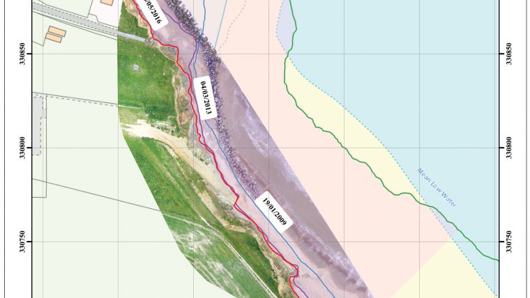
Coastal Management
UAS survey data collected at a coastal location on the UK’s East coast was successfully integrated with Environment Agency LiDAR data and analysed with the DSAS tool to help identify current shoreline positions and rates of erosion. The very high-resolution point cloud UAS data allowed a cliff toe-line to be easily identified in 3D and used as a shoreline proxy to calculate coastal erosion. High-resolution data including slope, cliff heights and areas covered by vegetation could easily be obtained with a standard RGB camera. Although it is unlikely that a UAS alone would be practical for surveying large sections of the coastline, the methodology used could provide considerable benefits for monitoring ‘hotspots’ along a stretch of coastline. UAS could be particularly useful for work in coastal zones, including applications where data quality is important; for example, in tidal areas or after a storm event. The almost immediate ability to deploy UAS and to capture data rapidly is something not possible with manned airborne systems or satellite imagery. Considering this, it would seem UAS could be used to play a role in the management of particularly vulnerable sections of coastline where UAS-derived data could easily be added to a database containing spatial information.
Summary and Conclusions
In summary, the examples above suggest that UAS can indeed produce high-quality ortho-images and DSMs. However, there are several caveats that should currently be observed. Most importantly, UAS flight parameters and data acquisition procedures need to be followed carefully to achieve the desirable results. Generally, these parameters will involve ensuring that an appropriate GSD, flight altitude and image overlap/side lap are used. Additionally, for non-RTK enabled UAS, high-quality GCPs and checkpoints will need to be captured.
Throughout all the data acquisition and processing stages in these examples, the equipment performed without fault. SfM photogrammetry software was able to correctly calibrate every image acquired from each flight despite the smaller image overlap settings and sub-optimal lighting conditions used to cover large area sites.
It can be concluded that low-cost UAS can be used as an effective image data collection tool in diverse geographical environments. When combined with GIS analysis, these platforms can offer the opportunity to provide unique information about such environments in unprecedented detail and at larger scales than previously possible. The rapid improvements in UAS technology, combined with falling costs, will likely see UAS becoming increasingly useful as data collection tools in archaeological, topographical surveying and coastal management applications.
UAS - The Ubiquitous Data Capture Tool?
There are undoubtedly several limitations that apply to low-cost UAS, including the inability to create accurate DSMs in heavily vegetated areas, and operate in very high winds and heavy rain. It is unlikely that UAS will fully replace current methods of topographical survey data collection. More realistically, in the near future, they will likely complement traditional surveying techniques and fill a gap in the market by taking advantage of their high data quality. Future technological developments including the use of RTK/PPK image geotagging, improved battery times and the maturing of cloud-based SfM data processing algorithms, will all likely increase the use of UAS, predominantly in environments which require non-invasive data collection techniques.

Value staying current with geomatics?
Stay on the map with our expertly curated newsletters.
We provide educational insights, industry updates, and inspiring stories to help you learn, grow, and reach your full potential in your field. Don't miss out - subscribe today and ensure you're always informed, educated, and inspired.
Choose your newsletter(s)


