UAS Use in Vegetation Inspections
How Drones Benefit Energy Companies
If vegetation comes into direct contact with power lines it can cause service disruption, not to mention fires or even electrocutions. To avoid such undesirable consequences, most energy companies spend approximately half of their budget on monitoring and managing the vegetation in the proximity of their power line network. Maintenance staff often conduct visual inspections on foot, or may use other means such as road vehicles or helicopters. The incorporation of UAS technologies into the pruning and trimming activities will bring interesting efficiency results to the sector, as demonstrated in this pilot project by Viesgo in Spain.
Energy company Viesgo recently worked on a medium-voltage power line maintenance project that required three-dimensional (3D) modelling of existing vegetation. The company had previously experimented with Lidar systems shipped on various platforms; this time the company wanted to try Lidar combined with an unmanned aerial system (UAS or ‘drone’) and launched a pilot project for some of its power lines. With a thousand employees, Viesgo serves more than 720,000 customers in Spain and Portugal, not only in the power distribution market but also in the power generation and gas & power trading markets. Viesgo currently distributes electricity through a network that stretches 31,150km and has 4,150MW of conventional and renewable power generation capacity.
Viesgo’s requirements for the project included:
- a point cloud density of at least 10-15 points/m²
- a topographic accuracy of 20cm in absolute coordinates
- capturing all elements within an exhaustive acquisition of target power lines (tower structure, power cables, insulators and, especially, crossing lines)
- inspecting various corridors with widths varying from 15m to 40m
- maintaining continuous and homogeneous data acquisition to ensure visibility of every cable and crossing line
- monitoring the temperature of the different elements, at all time, with an expected geodetic datum of UTM ETRS89 H30.
Equipment and post-processing
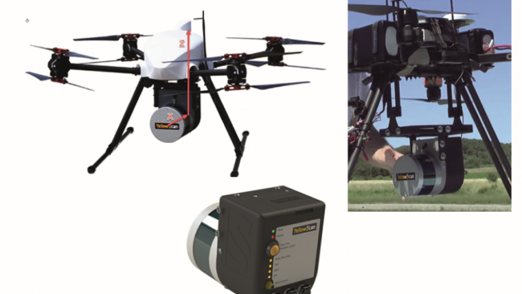
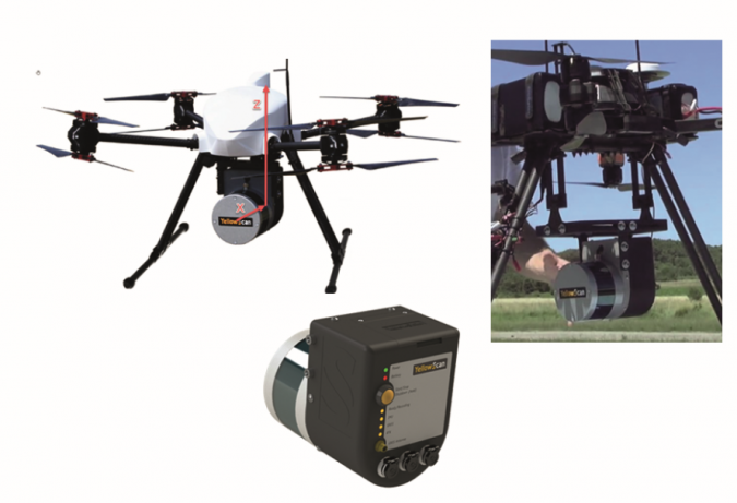
Viesgo chose as its project partner HEMAV, a Spanish drone service provider offering B2B analytics services, particularly focused on optimisation and maintenance of power grids. Using a surveyor Lidar system from YellowScan and flying at a height of approximately 20 metres above the power lines, HEMAV can map corridors with a width of 50m or – when mapping corridors with very few elements at ground level – up to 180m. Hence Viesgo’s corridor width requirements presented no problems.
In order to obtain a complete and optimally accurate analysis, the project team also embedded a thermographic and a visual camera on the multi-rotor system named HIR9. Successful integration called for two actions: firstly, the laser module needed to be placed as close as possible to the centre of gravity of the UAS in order to achieve the best possible stability of the drone during flights and to reduce any vibrations not absorbed by the damping system. Secondly, the GPS antenna needed to be placed on the top part of the drone, because the best GPS reception is achieved when the antenna is completely exposed to the open sky with no obstacles. Of course, the distance between the antenna and the sensor needs to remain fixed at all times. A GPS ground station at a maximum distance of 15km from the target area ensured absolute accuracy at centimetre level.
In the post-processing, a combination of POSPac UAV suite software and a GPS station with known coordinates was used to obtain a corrected trajectory, applied to a selection of flight lines of interest. Finally, all resulting data was exported in LAS file format. The main issue faced during post-processing was to deal with the gap within primary GNSS navigation data. This problem was solved by identifying GPS time within trajectory and recalculating trajectory correction after sub-dividing it into several trajectory segments as required.
Analysis and recommendations
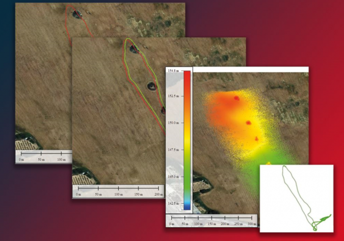
Once the point cloud files had been generated, the data analysis was performed and all requirements were delivered. One difficulty faced while working with Lidar was that the radar was initially unable to distinguish between high-voltage cables and medium-voltage ones, but the proper density was quickly found.
Concerning the calculated tree pruning, it was possible to give Viesgo recommendations about specific volumes of trimming in order to be certain of compliance with regulations. The company also received information about side fall areas and steep slopes so that it could avoid trees falling onto the power lines or surrounding objects. Interestingly, HEMAV developed new additional value by using predictive models of vegetation growth, based on its expertise in precision farming. This allowed delivery of risk models in the form of maps showing the risk of a fire due to the proximity of vegetation to a power line and the risk of service disruption due to a tree fall.

Another element worth mentioning is the minimum distance compliance at every crossing line area. In view of the fact that certain towers would receive two different line crossings at some point, it was very important that the regulations were respected concerning the distance at which the cables cross the towers. In performing this check, the project team was able to take into account the constant movement that an electrical cable has due to ‘normal’ natural climate conditions.
Future outlook
The pilot project was a success for both parties. First of all, it proved that data acquisition operations really can be done with lighter sensors for these types of activities. It is not easy to put a figure on how much money it saves, because circumstances and previously used methods vary. In HEMAV’s experience, however, a saving of between 20 and 30 percent is a realistic estimation. Obviously, the helicopter could still be the more economical option in large-scale surveys, e.g. a flying distance of 200km. However, UAS technology can also be a great tool to access areas with orographic complexity, such as mountain ranges and elevated land masses.
In terms of the trends that suggest more opportunities for savings in the near future, one important trend is that the use of public-reference vegetation databases will become easier in the years ahead. In combination with the right analytical software and predictive models, energy companies (or their advisors) will have a new instrument enabling them to plan the trimming and pruning campaigns without having to inspect everything themselves. That can also include satellite images; HEMAV has already worked on some projects of this kind. Since this type of information covers the whole planet, those files can be used as a first step to identify zones on which the power grid actors should focus. Once the public database has been checked, a second step is to add field data collected using UAS technology to further improve the accuracy of the public data.

Value staying current with geomatics?
Stay on the map with our expertly curated newsletters.
We provide educational insights, industry updates, and inspiring stories to help you learn, grow, and reach your full potential in your field. Don't miss out - subscribe today and ensure you're always informed, educated, and inspired.
Choose your newsletter(s)


