Unlocking Potential: Emerging Geospatial Trends for Business
Insights from the UN’s Future Trends Report
How can organizations and businesses advance their geospatial maturity in the coming years? The latest version of the Future Trends in Geospatial Information Management report by UN-GGIM captures technological and non-technological developments and signposts opportunities for change.
In 2020, the United Nations Committee of Experts in Global Geospatial Information Management (UN-GGIM) approved the publication of a periodic review of the third edition of the Future Trends report, led by Ordnance Survey (OS) on behalf of the UK and with contributions from over 100 experts and organizations. Since first being published in 2013, Future Trends in Geospatial Information Management: The Five to Ten Year Vision continues to provide strategic insight on the mid-to-long-term developments in geospatial information. This latest version captures changes and developments across both the technological and non-technological environments and signposts opportunities for organizations and businesses to adapt and advance their geospatial maturity in the coming years.
Report Findings and Structure
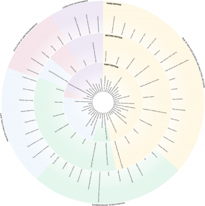
As expected, the increasing rate of change within the industry is one of the main findings in the report. Alongside emerging themes, the latest version showcases how geospatial information and technology solutions underpin economic growth and can act as a blueprint for business development. Figure 1 shows the growing number of themes and trends that have been covered in the report since it was first published.
The report recognizes the increase in adoption of data-centric technologies rather than ‘traditional’ IT technologies that handle data, the evolution of user demands and requirements, and the significance of partnerships and collaborations between the governmental, private and academic corners of the industry. It also documents the increasing role that geospatial information plays as part of the 2030 Agenda for Sustainable Development.
Its strength comes through the collaborative and global nature of the report’s contributions from across the globe, with 124 UN Member States, public and private-sector organizations and experts providing their input. A global consultation took place on the report in early 2020, with the findings presented and adopted at the Tenth Session of UN-GGIM in mid-2020.
Five Drivers for Future Change in Geospatial
For ease of reference, the report’s findings are grouped around five overarching industry drivers: industry structural shift, the rise of new data sources and analytical methods, technological advancements, user requirements, and policy and legal. Each driver is supported by a series of trends that provide a more detailed explanation of the topic and allow businesses to be aware of these evolving industry drivers.
The report is certainly relevant for emerging businesses, established organizations, entrepreneurs and individual geographic professionals alike. The key takeaways for many will be the opportunities provided by new sources of data, the rapid pace of technological advancements and the need for the appropriate skills and data privacy considerations to deliver against evolving user requirements.
Industry structural shift
The structural shift demonstrates the change in focus towards new expertise in consolidating large numbers of data sources whilst meeting a new generation of user requirements. This shift will impact the way of working together, necessitating great collaboration amongst data providers and users. The rise of smartphones and other mobile devices has increased expectation and user demand for higher accuracy, currency, and detail, so organizations will need to adapt their offering. Developments show that the data collected in GPS-assisted tracking systems by commercial parties in the automotive sector may be of subsequent real-time value to government agencies concerned with car tracking, traffic control and alternative road selection, reducing risk, road-based crime and the number or severity of traffic accidents. The market for such dynamic mobility data is predicted to be one of the fastest growing markets of the future.
Rise of new data sources & analytical methods
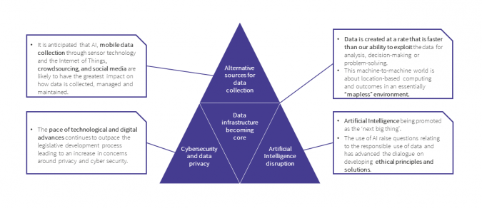
With ‘data everywhere’, the demand for analytical-ready data that reveals immediate insights is increasing beyond that of traditional geospatial datasets for visualization and analysis. The concept of big data analytics has been a constant theme since the first report in 2013. The volume, size, speed, diversity and complexities with which geospatial data is generated have already led to changes in organizations and businesses across the world. Findings have shown that change has taken place both in the infrastructure and processes used to collect, store, analyse and use data, as well as in the skills and expertise of the workforce. Cloud-based processing and access to sources of new and richer data is already giving rise to new applications and business opportunities.
Technological advancements
Some of the broadest and most powerful new geospatial trends continue to be associated with mainstream advancements in technology. The speed at which such innovation is occurring represents great opportunities, but it also challenges organizations and nations to keep pace. Advances in technology such as automation, artificial intelligence, sensor technology and the Internet of Things have created a shift towards a more machine-centric world. The continuous developments in technology call for accelerated training in future skillsets to keep up with technological capabilities whilst staying mindful of new questions of data privacy and cybersecurity.
User requirements
In recent years, the report has identified a notable shift in the requirements of users. At a citizen level this can be seen through growing numbers of location-based services, such as in transport or retail. This expectation of mobile, frictionless and convenient access to data increases the demand and opportunity for near-real-time data generation and analytics. At city level, the development of digital twins with associated citizen services is allowing local municipalities to simulate scenarios related to climate change and flooding events while mitigating risks and increasing infrastructure resilience. The popular rise of smart city infrastructures will serve as a platform for even greater engagement with citizens and planners.
Policy and legal
As is often the case, technology develops at a faster pace than the legal and policy frameworks that support it. Emergent technologies and disruptive business models are often at the forefront of these developments. The report recognizes that, as interdisciplinary collaborations are commonplace, this places even more emphasis on security, data privacy, ethics, trust and licensing requirements. There will be greater demand for governments and commercial organizations to consider these emerging legal and policy challenges as part of national frameworks for data and digital progression.
Evolving Future Trends
Needless to say, the biggest disruptions, biggest impacts and biggest opportunities for the geospatial industry will arise when one or more of these innovations come together. The report recognizes that its readers are starting with different experiences, operate in different national policy contexts and have different levels of geomaturity. There is therefore an opportunity for businesses to promote the use and affordability of technology and analytical methods in the short-to-medium term. Entrepreneurs in the geospatial sector are well placed to leverage the rapid pace of change and create tools and services that can be used for economic and societal growth.
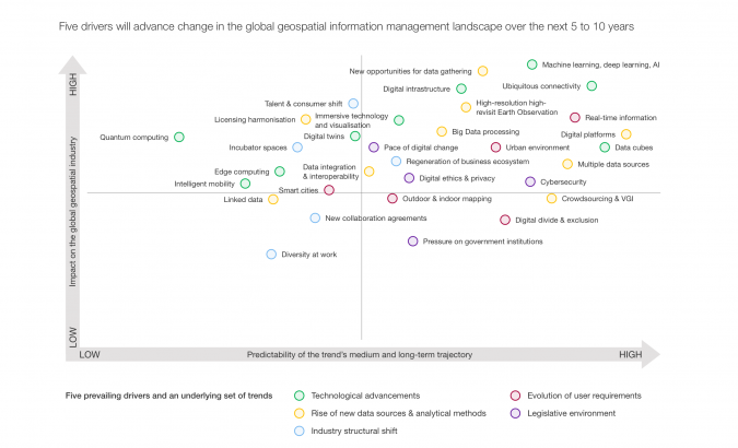
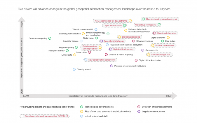
Figure 3 visualizes the drivers and the trends discussed in the report. The majority of these drivers and individual trends are classed as both ‘high impact’ and ‘high predictability’. The future of geospatial is clearly approaching very quickly and these trends bring a huge amount of opportunity as well as responsibility.
The capability of the geospatial community to deliver insightful data to meet key challenges is vital. It requires collaboration and strong leadership to help realize and communicate how high-quality, timely data can enable decision-making. It is clear that the increasing availability and decreasing costs of geospatial technology and new analytical methods have the potential to significantly reduce the global geospatial digital divide over the next decade.
Impact of the Pandemic
During 2020, COVID-19 accelerated the application of many of the trends in the report in ways that could not have previously been imagined – from the temporary halt in on-the-ground data collection which required the rapid identification and use of alternative data sources, to the need to integrate data from multiple sources whist maintaining its provenance and trust. In the post-COVID-19 world, it is likely that a number of trends will be accelerated to an even higher status of both ‘high impact’ and ‘high predictability’ sooner than expected.
The pandemic has underlined how geospatial infrastructures have become an essential component of disease prediction, prevention and response. From analysis of spatial big data to trace people’s movements to using contextualized data, digital maps and technologies to predict behaviour, and from visualizations that make data more easily accessible to machine learning techniques using aerial and satellite data, all of these techniques support the assessment of how environmental changes may impact infectious disease transmission. Several trends – such as data interoperability and real-time information and connectivity – have only gained in momentum, reinforcing how interconnected our world is and improving the global understanding of the interactions between people and places. The global response to COVID-19 has reminded the geospatial sector of the importance of both human and physical geographies working alongside one another.
Conclusion
The third edition of the Future Trends in Geospatial Information Management report reveals the speed at which the geospatial industry has evolved and is still evolving influenced by factors inside and outside the industry. This pace of change brings unprecedented opportunities to accelerate the development of a new generation of geospatial capabilities in response to demands being voiced by users and society as a whole. Although the geospatial trends identified in the report are focused on new technological developments, new data sources and a better understanding of user needs, the real value in this report comes from the encouragement of new ways of working, collaboration and the possibilities of new partnerships. The industry as a whole has a responsibility to use these new capabilities in pursuit of better outcomes – globally, nationally and locally. The lessons of 2020 have provided a clear demonstration of how important the geospatial industry is to a sustainable and better future.
Further Reading
A significant year for the UK on the global geospatial scene - Geospatial Commission (blog.gov.uk)

Value staying current with geomatics?
Stay on the map with our expertly curated newsletters.
We provide educational insights, industry updates, and inspiring stories to help you learn, grow, and reach your full potential in your field. Don't miss out - subscribe today and ensure you're always informed, educated, and inspired.
Choose your newsletter(s)


