Unmanned Aerial Vehicles for Glaciological Studies
Airborne Survey of Fountain Glacier’s Terminus Region
In July of 2010, researchers from the Department of Geography at the University of Calgary used a lightweight unmanned aerial vehicle (UAV) to carry out an airborne survey of the terminus region of Fountain Glacier on Bylot Island, in the Canadian Arctic. The survey comprised 16 flight lines, with a total of 148 photos being obtained from an average height of 300m above the glacier surface. A detailed surface model of the glacier and a 10cm resolution orthophoto were produced. The results from this survey will be used to quantify future changes in glacier mass and changes to surface flow patterns.
In recent years, great emphasis has been placed on documenting the effects of climate change in arctic regions. Studies of rapidly-changing glacial areas require accurate and regular measurements in order to quantify parameters such as mass-balance, retreat rates, and changing flow dynamics. Unfortunately the costs of regular monitoring programmes using aerial photogrammetry or high-resolution satellite imagery can be prohibitive, especially for remote arctic regions.
The advent of lightweight unmanned aerial vehicles (UAVs) has made it possible to carry out low-cost aerial photogrammetric surveys over small areas, at short notice. Such platforms are not capable of carrying a full sized aerial camera, so they use low-cost compact cameras and compensate by flying at lower altitudes. Providing that good ground control and a suitable camera calibration is available, there is no reason why good results cannot be obtained from a rigorous block adjustment of the photographs produced from such a survey.
Objective
The objective of the study was to carry out a comprehensive photogrammetric survey of the terminus region of Fountain Glacier, using a lightweight UAV. The resulting 3D model and orthophoto mosaic will be used to provide accurate baseline data for studies on glacier thinning and surface dynamics.
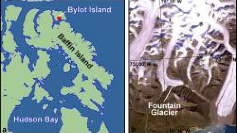
Location
The study area is situated on Bylot Island in the Canadian Arctic (see figure 1). Fountain Glacier is a relatively small arctic glacier, being around 15km long and about 1.3km wide close to its terminus. Since the early 1990s, the glacier has started to retreat rapidly, with retreat rates in excess of 10m per year being measured from recent satellite imagery.
The area around Fountain Glacier has been studied by researchers from the University of Calgary for several years. Current research interests include glacier/permafrost interactions (Dr Brian Moorman), glacial hydrology (Pablo Wainstein), and glacial surface dynamics (Ken Whitehead).
Arctic glaciers such as Fountain tend to be slow flowing, often showing high levels of inertia in their response to external stimuli. This is quite different from temperate mountain glaciers, which typically flow much faster and show more rapid responses to changing climatic conditions. While much is known about temperate glaciers, arctic glaciers, and particularly how they are likely to respond to changing climatic conditions, are still relatively poorly understood.
The UAV Configuration
The UAV system used for the survey was provided by Accuas Inc., of Salmon Arm, British Columbia. Accuas routinely uses UAVs to carry out small-scale photogrammetric surveys for applications such as engineering and estimation of stockpile volumes. For this project, the basic platform used was an Outlander UAV (see figures 2 and 3). This aircraft has a wingspan of about 2.5m, and is capable of carrying a payload of 0.5kg. Because of this weight limitation, the aircraft carries a lightweight Panasonic Lumix LX3 camera. Prior to the flight, the flight plan is uploaded to the autopilot. During the flight, the on-board GPS records the position, and the autopilot makes the necessary adjustments to keep the aircraft on course. On completion of the flight, the flight log is downloaded. This contains information on the position and orientation of all photos collected during the flight.
Control Survey
Prior to the flight, a comprehensive survey was carried out to establish ground control points (GCPs) on the glacier. Points were placed every 200 - 300 metres, across most of the terminus region, and consisted of 30cm diameter red targets. Larger 60cm diameter targets were used in darker moraine areas adjacent to the glacier. The ground control points were positioned using a Trimble real-time kinematic (RTK) global positioning system (GPS), with estimated relative horizontal and vertical accuracies of better than 5cm.
Flight Planning
In order to obtain photos at the required 10cm resolution, it was necessary to fly at a height of 300m above the glacier surface. Fountain Glacier is situated in a mountainous area, with many of the surrounding peaks exceeding 1,000m in height. Careful flight planning was therefore necessary. In addition, the surface elevation of the glacier varied by approximately 180m over the area of the survey. To avoid problems of varying photo scales and gaps in stereo coverage, the flight lines were flown across the glacier in a North / South direction, with the aircraft dropping by 12m between successive lines.
Flight planning was carried out using in-house Mission Planner software developed by Accuas. To avoid gaps in the stereo coverage, the overlap between photos and between adjacent strips was set to 65%. This high level of redundancy is typical for UAV surveys. Generally it is only necessary to use every second strip for processing, but the extra photos are there if needed.
During the flight, a total of 148 photos were taken. On landing however, the aircraft sustained structural damage, ruling out any further surveys during the field visit.
Processing
Processing was carried out at the Accuas office in Salmon Arm, using Trimble's Inpho software. Every second strip was used, with infill photos from the remaining strips being added to ensure full stereo coverage of the steep valley sides. Six GCPs, distributed over the surface of the glacier, were converted to check points to provide an independent estimate of the accuracy of triangulation. The remaining GCPs were used in the block adjustment, and were assigned horizontal and vertical standard deviations of 5cm. Another 10 existing targets from a separate study were incorporated in the block adjustment as vertical only control points and given a standard deviation of 20cm.
The GCPs used in the block adjustment had an average root mean square (RMS) error of better than 10cm in X, Y, and Z. All check points had horizontal residuals of better than 25cm in X and Y, while the worst Z residual at any check point was 54cm. This level of accuracy was more than sufficient to meet the project objectives. Using Inpho software, a 1m resolution digital surface model of the glacier was produced. This was used to generate a series of orthophotos, which were then combined using Trimble's OrthoVista software to produce a 10cm resolution orthophoto mosaic (see figure 4). The level of detail contained in this image is sufficient to produce a printed map 1.5m by 1.5m in extents, at a scale of 1:1,000.
Conclusions
The use of a lightweight UAV made it possible to obtain a detailed orthoimage and surface model of the terminus region of Fountain Glacier at an affordable price. The data gathered from this survey will help to catalogue the effects that changing climatic and environmental conditions have on Fountain Glacier. Future changes to the thickness and ice volume of the terminus region can be compared with this dataset to provide accurate information on thinning and retreat rates, and surface feature tracking can be used to determine changes in flow patterns over time.
Lightweight UAVs offer many advantages for field studies in remote areas. High-resolution aerial surveys can be carried out economically and at appropriate times. Where there are rapid changes occurring, multiple flights can be carried out over the course of a single field season. The time may not be too far off where UAV surveys become commonplace in field research.
Acknowledgements
Thanks are due to Accuas, Parks Canada, and the Polar Continental Shelf Project (PCSP) for logistical support.

Value staying current with geomatics?
Stay on the map with our expertly curated newsletters.
We provide educational insights, industry updates, and inspiring stories to help you learn, grow, and reach your full potential in your field. Don't miss out - subscribe today and ensure you're always informed, educated, and inspired.
Choose your newsletter(s)


