Use of GIS tools for land expansion in Colombia
Empowering indigenous communities with innovative mapping technology
Local indigenous youngsters in northern Colombia have mapped the boundaries and sacred sites of their village, Gunmaku in the Sierra Nevada of Santa Marta, and the indigenous authorities are happy with the result. The Dutch Kadaster is supporting the sustainable development of rural communities in Colombia by bringing smart GIS tools closer to remote communities to facilitate land administration. This project in Gunmaku shows how existing technology can empower indigenous communities to protect their lands.
Up until March 2022, as with many other parcels that the indigenous community is purchasing to recover its ancestral land, the limits of Gunmaku had never been well defined and property documents were not available. Therefore, indigenous youngsters received training in the use of GNSS antennas and mobile data collection apps. They then hiked through rough terrain to map the area that belongs to their community.
Expansion of the Indigenous Reserve
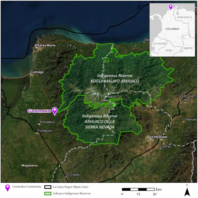
“We want to expand the existing Indigenous Reserve by 307,000 hectares to be able to protect the forests and rivers of the Sierra,” said Danilo Villafañe – leader of the Indigenous Arhuaco Community in Magdalena – in a meeting with the Colombian Ministry of Agriculture and other land institutions in February 2022. The Sierra Nevada of Santa Marta in northern Colombia was originally the territory of four ethnic indigenous groups, but nowadays it is populated with many settler farmers who arrived from other departments and who are producing coffee, bananas and palm oil. Therefore, the indigenous communities prefer not to use the word ‘expanding’; instead, they talk about ‘recovering’ or ‘reclaiming’ territory, since they consider it all ancestral land. This ancestral territory goes all the way up to the Linea Negra, an imaginary black line that consists of several indigenous sacred places (see map below), but where cities have arisen since the colonists arrived several centuries ago. Currently, the official indigenous territory in the Sierra Nevada is registered as an Indigenous Reserve and is, at approximately 640,000 hectares, much smaller than the original ancestral territory.
The indigenous community wants to recover part of its territory to conserve the natural resources in the Sierra Nevada. They consider themselves the ‘guardians of the Sierra’ and want to protect the nature there. Therefore, the community has requested government support for an extension of the Indigenous Reserve, something that needs to be done through the buyout of the settler farmers in the region. The indigenous community aspires to repurchase all the parcels within the proposed 307,000 hectares to annex this land to their Reserve. The farms that are purchased have often never been registered, and transactions between the farmers and the indigenous community are also informal. The community receives support from national and international organizations to be able to buy these farms, but only limited information is stored at the time of purchase. As a result, there is no database of the indigenous community’s land properties. The expanses of land are immense and hiring land surveyors is too expensive for the community. Since there are no maps of the indigenous parcels, the areas and locations are mostly unknown.
Lack of spatial information
The lack of spatial information limits the extent of the indigenous community’s objectives, since it is unknown what land is already regarded as their property and which parcels still need to be purchased by the community. To support these processes, the Dutch Kadaster (the cadastre, land registry and mapping agency of the Netherlands) is supporting the Arhuaco community through capacity building for parcel data collection using the fit-for-purpose land administration approach. Communities receive training to measure land boundaries and other relevant information in an efficient and transparent way, using smart and user-friendly GIS technologies. Consequently, young representatives of several indigenous communities came together for a training exercise in one of their villages, Gunmaku, to learn how to measure their territory.
Gunmaku community
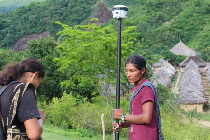
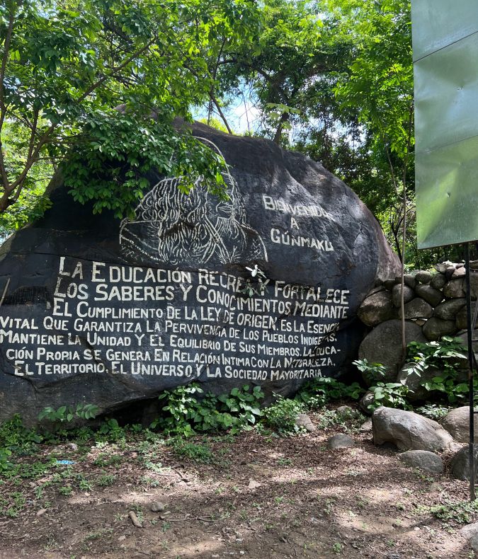
Gunmaku is an indigenous village in the Sierra Nevada of Santa Marta that is part of the Arhuaco ethnicity. The Arhuaco community has a strong cultural identity linked to the natural environment. Gunmaku is not part of the official Indigenous Reserve; instead, it is one of the parcels that the Colombian Government donated to the indigenous community in 2011 for the establishment of a so-called Pueblo Talanquero to create a safety corridor around the whole Sierra Nevada. The Gunmaku settlement has a mixed school attended not only by Arhuaco children, but also by children of Kogi and colonist farmers. It is one of the areas that is projected to be part of the official Reserve. However, the limits of Gunmaku have never been well defined and property documents are non-existent. Only the elders, the indigenous authorities, understand the extent and history of their territory. According to the authorities, their vision on the territory needs to be passed on to the youngest generation. Therefore, the maps of the village are not only for official registry purposes, but also to maintain traditional knowledge within the community.
Indigenous grassroots surveyors
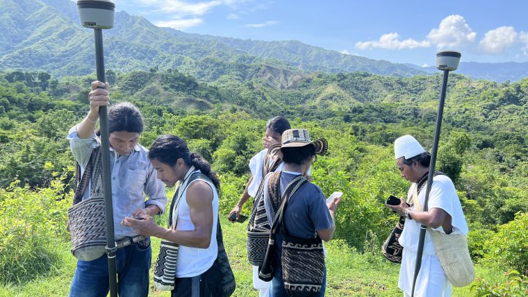
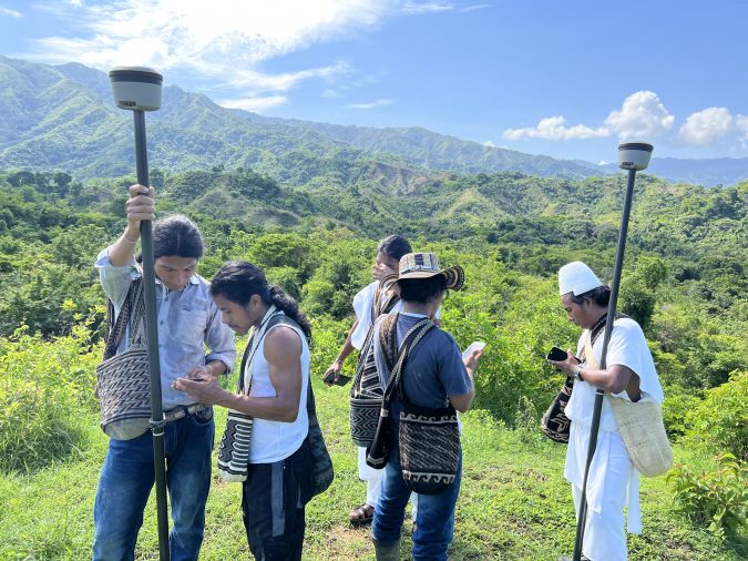
The 35 youngsters who were chosen by the indigenous authorities to participate in the training learned to measure parcels using the high-precision GNSS devices of Trimble and the Esri Field Maps app for data collection. It was a short and practical course that focused on issues including how to understand maps, how a GNSS device works, how to collect field data, and how satellite images can be used. The Field Maps app has been optimized by Kadaster and its partners to be able to store all relevant data in a simple and straightforward way, which made it easy for the community to learn how to use it. Likewise, Trimble’s GNSS antennas are user-friendly and measure according to the strict local standards, with the RTX correction services.
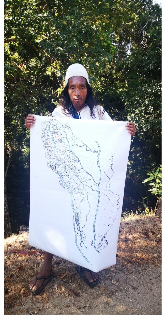
The training was not without its challenges; some of the youngsters even had to walk over eight hours to reach the training location in Gunmaku. But during the training, the youngsters were very motivated and one of the participants – Felipe – was particularly enthusiastic. Fascinated by maps but without the technical tools to map land, he showed the rest a quite accurate hand-drawn map of the area where he lives, indicating which parcels were occupied by the indigenous community and which parcels were occupied by settler farmers.
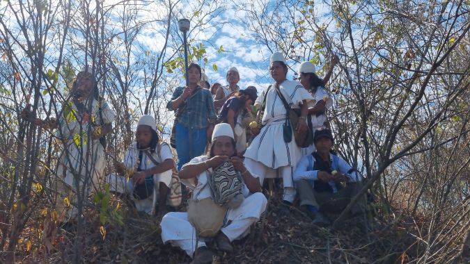
After a day of training, the community decided to measure the boundaries of the Gunmaku parcel. A large group of more than 40 representatives of the whole indigenous community was formed for the fieldwork. The elders led the group, since only they knew the precise location of the parcel boundaries, while the newly trained youngsters operated the measuring equipment. Besides the trained youngsters, many children from the local school in Gunmaku also joined in. Because this was an educational activity, the teachers gave the pupils a day off to accompany the fieldwork team.
Rough terrain
The trek to perform the measurements started by heading uphill, providing a beautiful overview of the indigenous territory, including blue sky, the Tucurinca river and a forest that had withstood the drought period but was slowly turning back to green. But the difficulty of the terrain was also directly visible. Five community members strode ahead of the fieldwork group, using their machetes to make the trocha (a small trail to give access to the terrain’s limits). Gunmaku is surrounded by densely forested mountains, so walking along the boundary is difficult and sometimes impossible. The limits are not marked with poles or fences, but instead the cut trails serve as an indication of the boundaries. The history of every boundary point of the territory was explained to the youngsters in their own language (Arhuaco), often taking up to 20 minutes per point (translation time not included). The consultants from Kadaster left the group after the first mountain, but the indigenous youngsters continued since they are more used to walking long distances in temperatures of over 30⁰C. The mapping of the complete boundaries took the group two days of exhausting but satisfying fieldwork.
Spiritual land
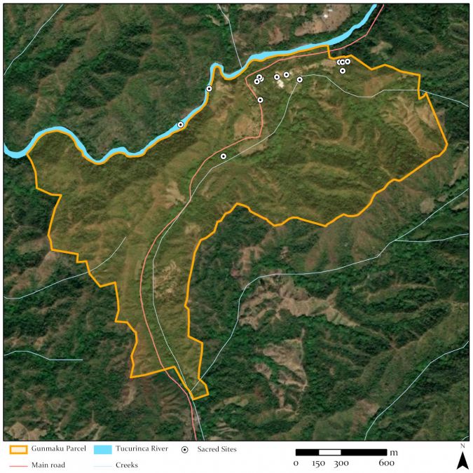
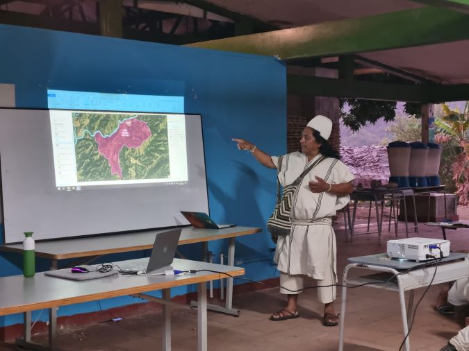
On the evening after the surveying activities, the participants presented and explained the map to the rest of the community. This was the first time that the indigenous authorities could see a map of the limits of Gunmaku, so they were delighted at the results and immediately requested a printed version.
Now that the limits of Gunmaku had been identified, it was also possible to locate sacred sites with which the community had a spiritual connection within the parcel. These sacred locations were searched for and named by the indigenous community and directly put on the digital map. The meaning of each sacred point was also added to make sure that the information will be preserved and understood by the youngest generation. The map also facilitated the identification of neighbouring farms, some of which are also the property of indigenous families while others are owned by settler farmers. These farms will at some point also need to be mapped, as will the other thousands of parcels that the community aspires to buy.
Conclusions
The work in Gunmaku shows the importance of empowering communities themselves to map their lands in order to protect their natural and cultural heritage. It can sometimes be challenging to provide access to existing smart GIS tools for groups that have a great need for them, but this project is an example of how the use of GIS technology has enabled young indigenous people from the isolated Arhuaco community in northern Colombia to map their surroundings for the first time, based on input from the indigenous elders about the boundaries of their territory. This will allow them to strengthen their negotiating position with the government in talks to recover their land and to make their area an official reserve.
Now it is up to the indigenous community to continue deploying these surveying methodologies in the rest of the area. There are still more than 300,000 hectares to measure, which can only be achieved by involving members of the community themselves. Obviously, the neighbouring farmers also need to be included in the activities, since the expansion of the Indigenous Reserve will have an impact on their current land occupation. They need to be willing to sell their parcels to the community.
The indigenous youngsters from various villages were enthusiastic and established a text group to enable them to maintain continuous contact in order to coordinate all their efforts. They are now eager to support the municipality’s cadastral updating process that will start in a few months. In the meantime, the indigenous authorities and the Colombian government will have to agree on the implementation of the methodology and make various decisions, such as whether to buy new GNSS equipment and how to plan the work in such a wide area. The Dutch Kadaster will continue to support the current processes by searching for more accessible equipment and helping the indigenous organization to establish a database for the land parcels.
Acknowledgements
This work is part of the LAND-at-scale programme in Colombia, financed by The Netherlands Enterprise Agency (RVO) and executed by Kadaster in cooperation with ICCO Cooperation and Tropenbos Colombia. Within this programme, Kadaster works with several Colombian land institutions such as the National Land Agency (ANT), Geographic Institute Agustín Codazzi (IGAC) and the Superintendency of Notaries and Registration (SNR).
Further reading
https://www.kadaster.com/about-us/gunmaku-colombia
Image courtesy: The Kadaster team in Colombia.

Value staying current with geomatics?
Stay on the map with our expertly curated newsletters.
We provide educational insights, industry updates, and inspiring stories to help you learn, grow, and reach your full potential in your field. Don't miss out - subscribe today and ensure you're always informed, educated, and inspired.
Choose your newsletter(s)


