Video games as an emerging application for navigation data
The rising popularity of 3D point clouds among developers
Perhaps surprisingly, video game development is becoming an increasingly popular use case for navigation and Lidar data. However, it is often overlooked amidst the almost endless possible applications for 3D point clouds, such as autonomous vehicle navigation, object detection or geospatial surveying. As personal computers (PCs) and gaming consoles become ever-more powerful, users demand more immersive experiences, particularly those that allow them to autonomously navigate around environments that they already know. This article discusses how navigation data is being used to aid video game development, and in turn allowing Lidar to take a leading role in this billion-dollar industry.
Lidar actually dates back to the 1960s, However, it is only since the acceleration of the digital world that the use of the technology has skyrocketed. As with any new technology, when it was first brought to market the cost per unit was high to enable the recovery of research and development costs. Over time, the price has come down as the technology has matured. This has put the technology into the hands of a much wider audience and, as a result, the number of new and innovative use cases has also increased.
Lidar, or more specifically automotive-grade Lidar, in its purest form is most well-known for its use in the autonomous vehicle industry, where it is used for real-time object detection and collision avoidance. However, from a surveying and mapping perspective, it can also be a useful tool for video game developers.
The versatility of the point cloud
The point cloud enables the real-time Lidar data from previously scanned objects to be retained and used to build up a picture of the environment that can be analysed at a later stage. To create a 3D point cloud, users must combine the measurements from an inertial navigation system (INS) with raw Lidar data (Figure 1). It is impossible to create a 3D point cloud without accurate INS data because the Lidar sensor needs to know where it is (position), its orientation and heading (navigation) and when in time it is (timing). This can be difficult to achieve without a sound understanding of coding. However, various software applications, such as OxTS Georeferencer, enable users to avoid complicated software engineering work. Once georeferencing is complete, the software will create a Packet Capture (PCAP) file that users can view in many point cloud viewer software applications.
Point clouds are useful for many wide and varied reasons. Autonomous vehicle developers may use point clouds to build up digital maps of cities to further aid object detection and avoidance, while geospatial surveyors may want to use a point cloud to determine road degradation over time or monitor the rate of coastal erosion. These are some of the more common use cases. As Lidar technology becomes ever-more accessible, new and inventive ways to use point clouds are emerging – including for video game development.
Popularity among game developers
The increase in data storage and processing capabilities of PCs and games consoles means that developers are under growing pressure to provide gamers with new, innovative and ever-expanding digital worlds to explore. One such way to do this is to allow gamers to explore their own environments in a digital setting. However, recreating even a small area manually would require a substantial amount of time. Lidar and point clouds solve this problem by offering developers a quicker, more cost-effective way of doing this.

Practical examples
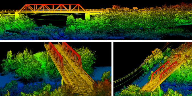
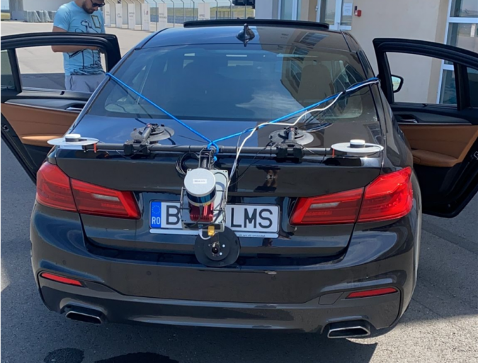
OxTS’s partner Dronezone SRL is one company which has discovered that video game development is a growing market for Lidar technology. Dronezone builds and hires out professional unmanned aerial vehicles (UAVs or ‘drones’). It builds UAV payloads comprising of Velodyne VLP-16 Lidar sensors and OxTS INS devices for use in a variety of Lidar survey projects. One of Dronezone’s customers used a payload to scan an aging railway bridge looking for possible weaknesses and deterioration over time (Figure 2).
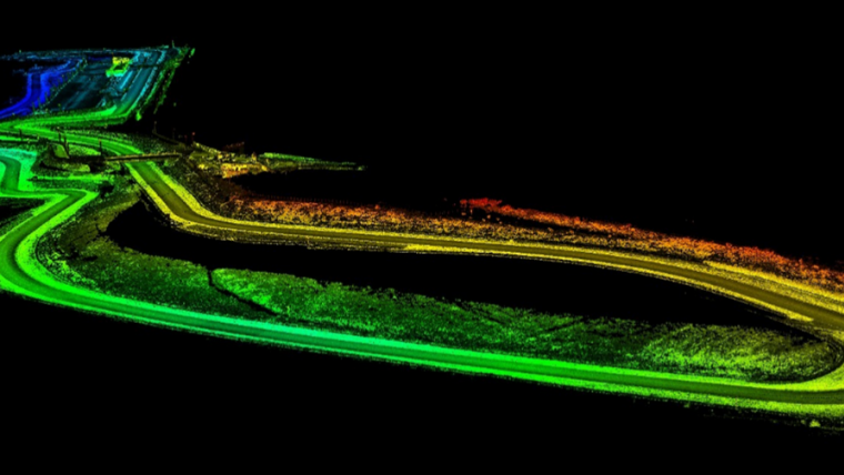
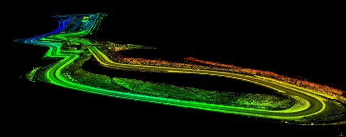
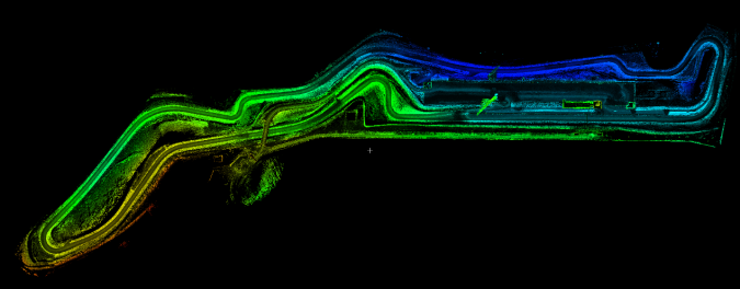
Although Dronezone traditionally gets involved with geospatial mapping projects, it is seeing an increasing need to cater for more niche applications. For example, Dronezone recently undertook an eye-catching project to survey the Transylvania Ring racetrack. The customer – a video game developer responsible for developing the racing simulator game called Assetto Corsa – wanted an accurate digital representation of the track contours as a basis for the start of the development work (Figure 3).
Creating the payload
For this project, Dronezone decided to move away from traditional UAV-based mapping to survey the track precisely using a Lidar sensor. Unlike with many off-the-shelf solutions, it was possible to take advantage of the flexibility of the Dronezone UAV payload by repurposing the hardware for use on a car. This setup enabled Dronezone to complete multiple laps of the track and create an accurate high-density point cloud of the full layout of the track (Figures 4 and 5).
To further improve results, Dronezone used the Boresight Calibration feature available within OxTS Georeferencer to calibrate the coordinate frames of the Lidar sensor and INS. This process, which involves a short survey of two retroreflective targets, increases the clarity of the final results and eliminates blurring and double vision.
Besides benefiting from the real-life accuracy of this representation of the entire track, the game developers at Dronezone’s customer could go back and analyse the point cloud whenever they wanted to without the need to revisit the location. This meant a significant amount of time, money and effort was saved during the development phase. The quality of the data produced has given Dronezone extra confidence that it can win more business from the same customer in terms of mapping further tracks for the video game.
The future of Lidar in gaming
This is just one example of the new and unique applications that are currently emerging as Lidar technology is democratizing. As the technology advances further, Lidar and navigation data is likely to be used for increasingly immersive and all-encompassing gaming experiences such as through virtual reality. At a recent exhibition, for example, Velodyne Lidar – an OxTS technology partner – demonstrated the use of a virtual reality headset to independently navigate within a point cloud. It is therefore highly likely that virtual reality will play a key role in the future of gaming.
As video game developers continue to push the boundaries of what is possible, this will drive a growing requirement to map larger, more widespread and difficult-to-reach environments. Technology such as Lidar and point clouds are particularly useful in terms of speeding up this process and saving time and effort. However, it is important to remember that Lidar cannot play a leading role in the future of the video game industry without accurate navigation data.

Value staying current with geomatics?
Stay on the map with our expertly curated newsletters.
We provide educational insights, industry updates, and inspiring stories to help you learn, grow, and reach your full potential in your field. Don't miss out - subscribe today and ensure you're always informed, educated, and inspired.
Choose your newsletter(s)


