What is Geomatics?
GEOMATICS@DIT provides Some answers
As the only educational institution offering a BSc (Hons) course in Geomatics (Surveying and Mapping) in the whole of the Republic of Ireland, the Dublin Institute of Technology (DIT) has noted a severe lack of awareness of what Geomatics encompasses both as a discipline and as a potential career. New marketing initiatives, including the use of an animated video on social networking sites, aim to ensure the survival of the course by informing potential Geomatics students about both the profession in general and the specific opportunities at DIT.
The Department of Spatial Information Sciences (DSIS) at the Dublin Institute of Technology (DIT), Bolton Street, Dublin is the only educational institution offering a BSc (Hons) course in Geomatics (Surveying and Mapping) in the whole of the Republic of Ireland. In recent years, the Department has sought to serve the GI industry further by developing and offering a Masters-level programme (MSc) in Spatial Information Management, which is aimed at mid-career, cross-sectoral professionals. In addition, a number of part-time programmes in Global Navigation Satellite Systems (GNSS), Geographical Information Systems (GIS) and Coordinate Reference Systems are delivered either directly or in an online, e-learning environment.
Valued Graduates
The DSIS is examining how to exploit its flexible delivery methods in the development of a suite of specialist postgraduate programmes in collaboration with other universities both nationally and internationally. It also maintains close links with practitioners in the Geomatics profession, with representatives of state, semi-state and private sector organisations being invited annually to meet with students and to discuss employment opportunities. From feedback received at such meetings, it is apparent that these programmes and their graduates are highly valued by the Geomatics/Spatial Information Management industry, both in Ireland and around the world. Indeed, on the international front, the DIT Admission Office is increasingly being asked to advise on educational requirements and equivalencies for non-Irish potential admission candidates. Further, the DSIS continues to develop strong ERASMUS links to facilitate international student exchange at both undergraduate and post-graduate levels.
However, reflecting the vulnerability that is currently being experienced by Geomatics educational courses across the globe, the Department is acutely mindful that it needs to continue to attract high-quality applicants to secure its survival. It is obvious that this will only be possible through improved awareness and, to this end, the DSIS has recently undertaken proactive marketing initiatives aimed at promoting the Geomatics profession generally - and the DSIS BSc (Hons) course specifically - throughout the Republic of Ireland. This included the production of a range of promotional material which is being used successfully by the Department during career open days, visits by lecturing staff to secondary schools and such like. Meanwhile, recent graduates and current students are being encouraged to visit their local schools to promote awareness of Geomatics as a potential career path for school-leavers.
New Initiatives
Despite all of these activities, there continues to be evidence of a severe lack of understanding of what Geomatics encompasses both as discipline and as a potential career. In order to rectify this, DSIS decided a novel approach was required. Marking the first of a number of innovative initiatives, DSIS came up with the idea of developing a short video specifically designed for social networking sites (YouTube, Facebook, etc.) with the simple aim of providing answers to ‘What is Geomatics?' - a question which is often posed by prospective students, their parents, secondary-school teachers and the general public. The brief was to develop a media clip that used highly focused content to visually detail the breadth of Geomatics professional competencies, the cross-sectoral nature of the discipline and the inter-professionalism of Geomatics as a potential career path. The DSIS commissioned the company Baboom Design Ltd. to bring the content to life using unique ‘cartoon-feel' animations. After two initial brainstorming meetings between DSIS lecturing staff and Baboom Design Ltd., work began to collectively create an outline storyboard and to identify keyscreens for the video.
Animation
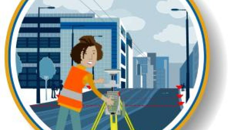
The decision to create this media clip using animation was a strategic one which sought to ensure longevity of the product and to ensure that the ‘look and feel' did not detract from the message itself. In short, the animations were intended to be timeless in character and bold in statement. The movie screen was broken into three sections to give the key DIT branding and title elements consistency and clarity. The main message of each screen needed to illustrate two specific points: the wide-ranging career paths available to any potential students and the diversity of subjects within the Geomatics discipline. The top header panel was created to display the text ‘Geomatics is...' with the DIT course code (DT112) shown above it and references to the various subject areas on the top right-hand side of the screen. The main section contains illustrated animations and screen notes for each animation, while the footer panel shows the DIT logo on the bottom left and a career icon and label on the bottom right of the screen. It was important that the graphic style for the characters, backgrounds and layouts (Figure 1) were appropriate for the target audience and, to achieve this, a minimal palette of colours was used (with most background elements being illustrated in blues from the DIT branding palette) and key elements including characters were shown in bold colours. It was the intention that these characters should look like recent graduates and should reflect a good gender and ethnic mix (Figure 2).
The final media clip is 4.5 minutes long, and a number of versions of the movie were created, including a stand-alone version for presentation purposes and an internet version with loading screen and embedded .html file. While recognising that voice-over might have been useful to give scripted extra detail, it was decided that a carefully selected looping music clip (copyright-free to avoid extra costs) was more preferable in view of the intended audience. Feedback to date has confirmed that this was indeed the correct choice for now, although it may still be decided to include this voice-over facility in the future.
Assessing the Impact
The impact of this media clip is currently being evaluated. Initial reactions to the product have been universally very positive, with the appeal of the clip's unique animation and the simplicity of its message appearing pivotal to its success. Despite much of the storyboard and keyscreen development and subsequent editing being done within an online environment, the DSIS lecturing staff found the process of providing their input and comments, which were essential to the project, to be very time-consuming, and the time spent on this input is difficult to quantify. An approximate estimation of actual completion time would be around 148 production hours, which breaks down into 52 man-hours for design and preparation and 96 man-hours for animation development and editing. High-quality animation such as this is generally expensive to create. However, Baboom Design Ltd. was aware that this project was constrained by a very limited budget and worked as efficiently as possible throughout, so that the overall cost including VAT was under EUR5,000.
Distribution
Just as the Land Surveying discipline has evolved into the future-facing specialism of Geomatics, the method of communicating our message demands a modern approach too. The media clip is currently available to a worldwide audience thanks to its inclusion on a range of websites, including YouTube, Facebook, the DSIS's own website 1 and many global surveying websites such as 2, 3 and 4. Helping to spread the word further, many students have added the clip to their own social networking sites as a way of explaining to friends and family what Geomatics is all about. The DSIS is continuing to develop further Geomatics-related promotional material and urges other Geomatics educational and professional bodies to follow its lead in this regard. When shown to the current DSIS
BSc (Hons) Geomatics first year cohort of students, many exclaimed ‘So now I know what I am studying!' and that in itself is a result!
Acknowledgements
Thanks are due to the DSIS lecturing staff, to Baboom Design Ltd., 5, and to the Society of Chartered Surveyors (Republic of Ireland) for support during the FIG Working Week 2011.
Further Reading
-
Murray-O'Connor, H (2011). What is Geomatics? An evolving discipline requires innovative methods to raise awareness (presented in the techncial session TS08H - Marketing and Management of Professional Survey Education at the FIG Working Week 2011, Bridging the Gap between Cultures, Marrakech, Morocco, 18-22 May 2011).
-
Murray-O'Connor, H (2011). Spatial Data Management within the Coastal Zone. Coastal Management, 1521-0421, Volume 39, Issue 2, 2011, pp 198-221.

Value staying current with geomatics?
Stay on the map with our expertly curated newsletters.
We provide educational insights, industry updates, and inspiring stories to help you learn, grow, and reach your full potential in your field. Don't miss out - subscribe today and ensure you're always informed, educated, and inspired.
Choose your newsletter(s)


