Wildlife Management Using Airborne Lidar
Finding Murrelet Habitat
The traditional sampling protocol for quantifying potential nesting habitat for murrelet requires an observer to peer up through the tree crown from the forest floor, a task resulting in data of dubious quality. Two-dimensional features of the canopy surface can be quantified using satellite imagery, but the three-dimensional attributes of the inaccessible middle strata of the canopy are the most critical to understanding and mapping the habitat. The development of Lidar as a tool for quantifying forest structure offers great promise of new solutions to existing habitat measurement problems and opens up a new realm of possibilities for exploring wildlife-habitat relationships. Read on to learn more.
(By Joan Hagar, Dave Vesely and Patricia Haggerty)
From the forest floor beneath a stand of old-growth Douglas fir trees in North America’s Pacific Northwest, it is difficult to perceive the grand dimensions of the tree canopy towering overhead. Early pioneers in the region clearly saw the economic value of the colossal boles and they industriously began harvesting the wealth of timber amassed in the region’s productive forests. Now, more than a century after the first giant was felled by a cross-cut saw, societal concern over loss of unique ecological communities has slowed the rate of timber harvest on public lands, ushering in a new era of biodiversity conservation. Consequently forest managers, who used to spend their time planning timber sales, have been assigned the new mission of protecting habitats for threatened and endangered species. With this new responsibility comes a need for a different way of measuring and mapping forest resources.
Mapping Challenges
Forest management in the coastal region of the Pacific Northwest is designed in part to maintain and improve habitat conditions for threatened species. The recovery plan for one threatened North Pacific seabird species that depends on old-growth forest, the marbled murrelet, calls for more accurate mapping of priority areas for conservation and restoration. But mapping nesting sites and collecting habitat data for a species that nests in the inaccessible heights of the canopy presents daunting challenges for researchers and managers. The forester’s stock-and-trade metrics of basal area, timber volume and board feet barely begin to describe the complex array of resources that comprise habitats for creatures dwelling in the three-dimensional world of forest foliage.
Along the southern coast of Oregon, the Coos Bay District of the Bureau of Land Management (BLM), a federal agency charged with balancing timber harvest and wildlife conservation, offers the perfect juxtaposition of marine and forested environments that defines ideal habitat for murrelets. When the murrelet was declared a threatened species, habitat management became a resource-consuming task for this district. Recently acquired Lidar data afforded the BLM an opportunity to explore the capabilities of this technology for improving methods of quantifying habitat for canopy-dwelling species.
With Lidar data acquired in 2008, researchers with the U.S. Geological Survey (USGS) and collaborating organisations tested more than 60 Lidar-derived variables in an exploratory analysis of murrelet habitat. The goal was to refine understanding of the structural features that comprise the best nesting habitat by identifying metrics associated with the presence of nesting murrelets. The preference of murrelets for large trees and multiple layers of sheltering canopy foliage is well established, but an objective and repeatable way of estimating available habitat has been lacking. Providing direct measurements of both vertical and horizontal vegetation distribution, Lidar is capable of delivering fine-scale canopy metrics that are unattainable from either ground plots or other remote sensing methods.
Outperforming Other Remote Sensing Metrics
Lidar data was collected between 3 May and 28 September 2008 using a Leica ALS50 Phase II sensor flown in a Cessna Caravan 208B. Average pulse density was 8.1/m2 and up to four returns per pulse were recorded. Vertical root mean square error was 0.05m. Raw Lidar point files (LAS format) were processed using the FUSION software package, developed by the US Forest Service, Pacific Northwest Research Station. The Gridmetrics routine within FUSION produced a set of metrics describing forest cover, forest height and topographic characteristics for the entire project area (approx. 652,000ha) at a pixel size of 22.9m. The upper height limit for determining outlying returns was adjusted to provide for trees of height >91m. A canopy surface raster at the 0.9m pixel size was produced by subtracting the ground surface was from the highest hits layer.
Five Lidar variables turned out to be strongly associated with murrelet occurrence (Figure 1): percentage of all returns above the mean height (all cover above mean), height of 99th percentile of first returns (P99), height of 10th percentile of first returns, standard deviation of percentage of first returns above the modal height (first cover above mode), and kurtosis of height distribution. Collectively, these variables described dimensions of canopy structure that reflect age-related characteristics of forest stands, consistent with the species’ known affinity for old-growth forest. Large values of the maximum height of the canopy (P99), accurately measured by Lidar, together with high values of the two metrics quantifying cover in the upper portion of the canopy (all cover above mean and first cover above mode) indicated the importance of tree crowns comprising proportions that take many decades, if not centuries, to develop.
Kurtosis is a statistical term indicating the extent of peakedness of a distribution curve. The kurtosis of height distribution is a metric describing the vertical stratification of canopy vegetation (Figure 2). It provides an excellent application of Lidar data, where complex ecological gradients can be quantified with a single, objectively measured, biologically meaningful metric.
Predicting Murrelet Habitat
In this case, very peaked curves had most of the vegetation distributed across a narrow range of canopy heights and relatively high values of kurtosis; flatter curves had vegetation distributed more broadly across a range of heights and relatively lower kurtosis. Lower values of this metric were indicative of structurally complex, multilayered canopies and predicted a greater chance that murrelets would use the site for nesting. This directly measured index of the vertical stratification of canopy foliage provides a more accurate and scientifically rigorous alternative to a variable (“number of canopy layers”) that is defined categorically and estimated subjectively.
When tested against variables derived from ground- and satellite-based data, these Lidar variables predicted which sites in the Coos Bay District were occupied by murrelets more accurately. The superiority of Lidar comes from its ability to provide three-dimensional measurements of forest structure, whereas ground- and satellite-based data is limited to two-dimensional habitat features. Furthermore, by providing continuous rather than categorical metrics describing vegetation structure, Lidar allows for more realistic representation of the ecological gradients that influence the choice of nesting location by the murrelet.
Better Management
Wildlife biologists understand that complex canopy structure is an important habitat attribute for wildlife species associated with old forests. At the same time, however, the grand dimensions of these forests that define high-quality habitat create equally grand challenges for mensuration. Biologists have struggled with methodology for measuring the attributes of old-growth tree canopies towering more than 50m above the forest floor.
Accurate and reliable wildlife habitat models are critical for predicting where species occur in order to guide habitat management. The Lidar-derived model of murrelet habitat exemplifies the potential of this data type for more effective management practices. It has been employed by the Coos Bay BLM to quickly and accurately map priority areas for surveys and conservation in the district. The capability of Lidar as a predictive tool for developing better occupancy maps is also being applied to other threatened and endangered species including the northern spotted owl and red tree vole, both of which also dwell in the inaccessible canopy of Pacific Northwest forests.
Figures
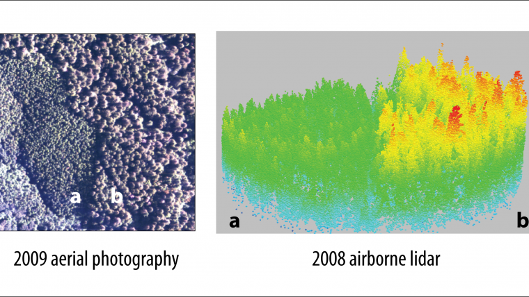
Figure 1, Aerial photograph and Lidar point cloud showing contrast in habitat structure between a 50-year-old forest stand (a) with a low probability (0.17) of use by marbled murrelets, and a 160-year-old forest stand (b) with a high probability of use (0.72).
Figure 2, Better habitat for marbled murrelets in older stands was indicated by lower values of kurtosis, measured when foliage was broadly distributed across the canopy height profile, as shown by the flat distribution in the histogram on the right (kurtosis = 1.35), in contrast to the peaked distribution for a young stand shown on the left (kurtosis = 2.21).
Courtesy for marbled murrelet image: www.HamerEnvironmental.com
Biographies of the Authors
Joan Hagar is a research wildlife biologist with the U.S. Geological Survey in Corvallis, Oregon. Her research on wildlife habitat relationships supports conservation of biodiversity in managed forests.
e-mail: joan_hagar@usgs.gov
Dave Vesely is a wildlife ecologist with the Oregon Wildlife Institute, specialising in the assessment of the effects of land use on wildlife populations and their habitats.
e-mail: dave@oregonwildlife.org
Patricia Haggerty is a GIS coordinator with the U.S. Geological Survey in Corvallis, Oregon. She provides spatial data management and GIS support for ecological research, including Lidar analysis for wildlife habitats.
e-mail: phaggerty@usgs.gov

Value staying current with geomatics?
Stay on the map with our expertly curated newsletters.
We provide educational insights, industry updates, and inspiring stories to help you learn, grow, and reach your full potential in your field. Don't miss out - subscribe today and ensure you're always informed, educated, and inspired.
Choose your newsletter(s)


