The drone industry is rapidly growing and will continue to expand in the future. Unmanned aerial vehicles (UAVs) make various applications easier, such as commercial delivery, mapping and search & rescue. Along with the economic benefits they create, these tools also speed up data collection and reduce the workload of the enforcement teams. Ongoing technological advances, such as algorithms to avoid obstacles and planned network configuration, increasingly allow pilots to fly their aircraft beyond the visual line of sight (VLOS), thus opening up the option of autopilot. Federal and local governments are now optimizing drone-related regulations to ensure aviation safety. This will enable everyone to benefit as the industry matures.
Current UAV Applications
Drones have been widely used for commercial deliveries in recent years. Drone Delivery Canada Corp. (DDC) has recently proved its ability to transport temperature-controlled medical supplies and blood test samples to remote areas using a drone service, and discussions are currently underway with federal and provincial government agencies about using its drones to distribute vaccines for time-critical deliveries. The company is also planning to integrate artificial intelligence (AI) into its drone delivery solution.
UAVs are also well known for their ability for large-scale data collection. For example, in a recent project they were used to inspect 4,000 miles of power transmission lines in Ohio, USA, using photogrammetry. The mapping practices are not limited to ground features only. For instance, CAT Strategic Metal Corporation is planning to begin a high-resolution magnetic survey for approximately 1,200 hectares of land in the Bathurst Mining District of New Brunswick, Canada, to map the magnetic disruption. A detailed structural map will be created to locate copper-silver concentrations.
The Future of Drones
Technological advancement has removed many of the limitations on drone operations. Thanks to their advantages of efficiency, accessibility and durability, drones are a good alternative solution for many other methods.
Local authorities are getting familiar with drones for their daily search & rescue operations. The Civil Air Search and Rescue Association of Canada has cooperated with Kongsberg Geospatial and Larus Technologies to develop a search & rescue solution based on AI with deep learning techniques. The missions are to be carried out in remote areas near the Arctic, and drone operations can assist rescue teams in narrowing down search areas efficiently and effectively, especially under extreme weather conditions. Similar activities can be conducted in an urban context. For instance, police departments can use UAVs to perform routine patrols in rural and coastal areas, with different flying routes created to keep an eye on local communities. Drones can also be used in combination with thermal imagery to find missing persons, such as in the case of an Amber Alert for a missing child.
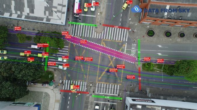
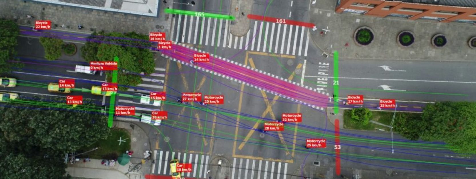
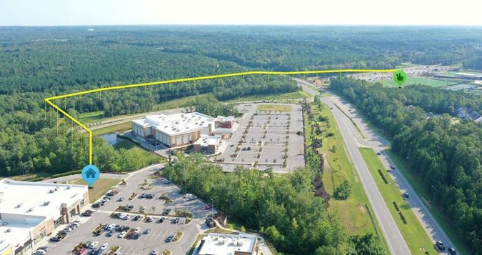
Drone imagery is also a potential tool for vehicle identification or for conducting traffic surveys of busy intersections, thus reducing the manpower normally required. The engineers can deploy more than one UAV at the same time to increase efficiency. Machine learning technologies can assist in counting the volume of road traffic, and the results can be used to study and develop solutions for congestion hotspots.
Drone operations can also have leisure-related applications. They can enhance the broadcast of live footage of races such as the Tour de France, World Rally Championship or marathons. Since UAVs are more mobile and agile than cars, they make it easier to capture better footage, plus they help to reduce carbon emissions.
Urgent Need for UAV-related Regulations
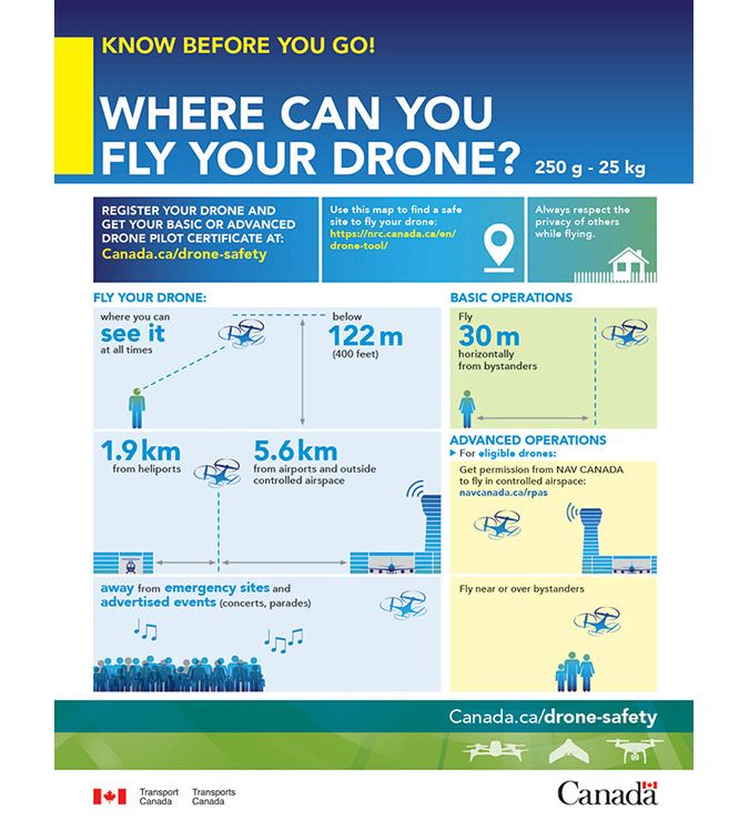
Despite the convenience of drones, their potential threats to the community or the environment should not be overlooked. Air traffic safety is the biggest concern due to the risk of injuries to the general public. In most situations, drones are not allowed to fly over controlled airspace and near clusters of people. In the USA, the Federal Aviation Administration (FAA) introduced two new safety rules associated with drone operations in December 2020 in order to enhance aviation safety and encourage more commercial applications in the future. Categorizing drones by registration will generate more information about the types and sizes of drones in the market. Each flying application will state types of flight operations with flying height details and nearby environments, allowing the air traffic to be monitored in real time.
Operations in regions near the North Pole/South Pole may be more susceptible to being affected by magnetic interferences. Further studies are required to find out the best season and time for UAV operations to minimize risks. Additionally, flight frequencies could be affected by targeted radio or cellular jamming or electronic devices such as medical equipment in hospitals. Operators may therefore need to create specific encrypted channels for urban missions.
Ideally, drone traffic should have the same characteristics as road traffic and authorities are now working to define drone ‘roads’ in the air. Airmatrix, a Canadian company specializing in air traffic solutions, is working with Transport Canada to assess aviation routes: detailed maps of specific routes at 400 feet above ground level. With the help of algorithms to assist the autopilot, the UAVs can avoid nearby obstacles and each other. Medicines can be transported from pharmacies to care homes using drones, as successful test flights conducted in Waterloo, Ontario, have shown. Law enforcement/rescue teams should be given temporary authority to land all nearby drones in case of an emergency. Moreover, to decrease the risk of air traffic accidents, safe flying zones could be defined for recreation purposes to keep drones from flying in random locations.
UAVs are a powerful resource which can reduce on-site labour, provide professionals with a better understanding of the data, as well as opening up new services – and hence improving the quality of life – for people living in remote areas.
The original version of this article was published on GoGeomatics, a popular communications hub promoting the Canadian geospatial community.
Further reading
[3]: https://www.baystreet.ca/viewarticle.aspx?id=625637
[5]: https://www.cbc.ca/news/canada/prince-edward-island/pei-thermal-imaging-drone-rescue-1.5849766