Ordnance Survey partners with OxTS
Ordnance Survey, the national mapping agency for Great Britain, was in need of a faster and more cos...


Whether the mode of collection is land-based, aerial, or marine, our robust GNSS-aided inertial navigation systems provide accurate georeferencing data around the world.
OxTS’ INS solutions are trusted by companies across a myriad of industries worldwide to capture precise measurements for survey and mapping applications.
OxTS offer proven inertial navigation solutions to help you capture the precise measurements you need for aerial mapping applications, again and again, time after time.
The integrated GNSS and inertial technologies of our solutions enable direct georeferencing in the air, increasing efficiency and streamlining the workflow.
Eliminate the necessity for ground control points (GCPs) and reduce sidelap requirements, saving time and effort and simplifying post-processing.
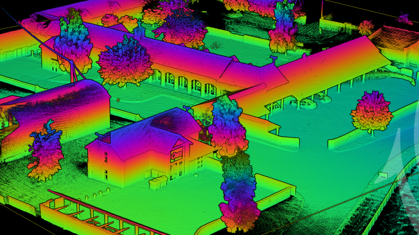
Our systems for mobile mapping seamlessly integrate GNSS with inertial measurements to generate accurate and consistent position, orientation, and heading.
The sensor fusion and tight-coupling allow data to be collected even in poor GNSS environments such as in forests or urban canyons.
Trajectory is recorded at up to 250 Hz and synchronised with LiDAR and other external imaging sensors. Once installed, our systems can be left to operate without needing repeat configuration or maintenance.
We provide a range of one-box GNSS/INS solutions capable of measuring position, heading and orientation for direct georeferencing for commercial UAVs.
Our solutions are equipped with inputs and outputs that can be directly interfaced to remote sensing equipment while we also offer bespoke technology integration and consultancy with LiDAR OEMs and system integrators.
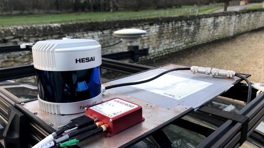
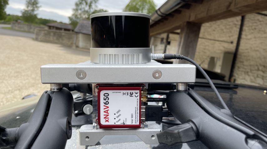
Measuring only 77 x 63 x 24 mm the xNAV650 is our smallest INS to date. Its small form factor is ideal for any application where space is limited making it ideal for UAV based mapping. When weight is a factor look no further than the xNAV650 INS. Weighing just 130 g, the xNAV650 is the ideal partner when precision is crucial, but the payload needs to be as light as possible. A lighter payload and lower power consumption means longer flight times for UAVs.


Ordnance Survey, the national mapping agency for Great Britain, was in need of a faster and more cos...

At OxTS, in line with our brand promise of being inertial navigation experts, our commitment to our...

We rarely stop to appreciate just how complex modern surveying technology is. Surveyors use the most...

Succeed With Confidence As Part of OxTS' Global Network OxTS has grown rapidly over the last few ye...

An inertial navigation system (INS) is a critical part of a surveyor’s armoury. The measuremen...

The xNAV650 is OxTS’ smallest (77 x 63 x 24 mm) and lightest (130 g) housed Inertial Navigation System (INS) yet. The device makes use of the latest cutting edg...

Survey+ inertial navigation systems from Oxford Technical Solutions combine the best of GNSS positioning technology with high-grade gyros and accelerometers to...
This site uses cookies. By continuing to use this website, you agree to our Cookies Policy. Agree