3D City Models of Paris and Florence
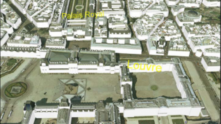
CyberCity AG (Switzerland) has extended its library of European 3D city models with two impressive datasets: Paris and Florence. Paris 3D is a highly detailed 3D model of the city of Paris.
It covers the 20 city districts with an extent of 90km2 and includes more than 200'000 reality-based 3D building models, generated semi-automatically from aerial images (dated June 2005) with the specialised photogrammetric software CyberCity-Modeler. CyberCity distributes the 3D city model, the detailed digital terrain model and the orthophoto (AeroGRID France, 12.5cm and 25cm resolution).
Florence 3D was generated from 20cm-resolution digital aerial images (dated June 2006) with the same semi-automatic approach and photogrammetric means. Florence 3D includes the detailed 3D model of the city centre (approx. 3km2), the simplified 3D model of the surrounding (approx. 37km2), the digital terrain model and the 20cm-resolution orthophoto. The detailed 3D model for the complete area can be generated on request.
Paris 3D and Florence 3D are available in regular tiles of 500 x 500 metre in most common formats for GIS, CAD and visualisation software, for applications in various fields, including urban planning and disaster simulations, engineering and architecture, security management, tourism, real-estate or computer games.
Source: CyberCity

Value staying current with geomatics?
Stay on the map with our expertly curated newsletters.
We provide educational insights, industry updates, and inspiring stories to help you learn, grow, and reach your full potential in your field. Don't miss out - subscribe today and ensure you're always informed, educated, and inspired.
Choose your newsletter(s)


