3D Laser Mapping Launches Riegl LPM 321
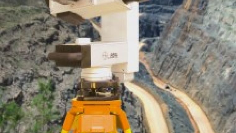
3D Laser Mapping (United Kingdom) has launched a laser profile measuring system achieving high accuracy measurements at ranges of up to 6 kilometres: the Riegl LPM 321 which is suited for inhospitable, inaccessible and dangerous environments such as those encountered in mining, engineering and archaeological projects.
The Riegl LMP 321 uses laser beams to measure the position of features and surfaces, recording up to 1,000 points per second with millimetre accuracy the system is robust yet lightweight, easy to use and includes an integrated Canon digital camera for capture of fully referenced images of the scene being surveyed.
3D laser scanners capture highly accurate and detailed measurements by transmitting optical pulses that are reflected from the surface or feature back to an integrated receiver unit. Using the time taken for each individual pulse to be returned and the known value of the speed of light the system can accurately calculate the distance of the feature from the scanning unit. The Riegl LPM 321 offers reflectorless ranging (i.e. the pulse is reflected from the actual surface or feature rather than a specially positioned reflector unit) with automatic or manual operation. Capturing up to 1,000 measurements per second, with a typical accuracy of 25mm accuracy, the system was designed for use in dangerous or inaccessible environments.

Value staying current with geomatics?
Stay on the map with our expertly curated newsletters.
We provide educational insights, industry updates, and inspiring stories to help you learn, grow, and reach your full potential in your field. Don't miss out - subscribe today and ensure you're always informed, educated, and inspired.
Choose your newsletter(s)


