3D Laser Mapping Launches Telecoms WireFinder
3D Laser Mapping (United Kingdom) has launched a new mobile mapping system specifically designed to capture highly accurate 3D measurements of overhead telecom networks.
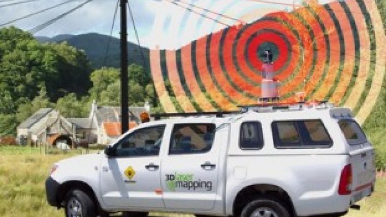
The vehicle mounted WireFinder system uses the latest laser technology and specially designed software to accurately measure the position of telecom network assets, such as poles and wires. Offering an unrivalled technical specification the WireFinder also delivers operating efficiencies and reduced risk to personnel in the field.
The WireFinder uses a Riegl 3D laser scanner controlled by software specifically developed for this application by 3D Laser Mapping. The positions of telecom network assets are measured, using laser beams, with unrivalled speed, precision and repeatability.
An integrated satellite positioning system enables these measurements to be geo-referenced to real world co-ordinates making the resulting data suitable for use in a GIS environment. The system, which is mounted on the roof of a 4x4 or other suitable vehicle, is used while stationary, making the WireFinder solution significantly safer than existing systems where survey staff have to stand in the road while recording measurements.
WireFinder has been developed in direct response to demand from telecoms maintenance operators in Europe and the USA. Dr Graham Hunter, managing director of 3D Laser Mapping commented,
3D laser scanners capture highly accurate and detailed surface measurements by transmitting optical pulses that are reflected from the surface or feature. Using the time taken for each individual pulse to be returned and the known value of the speed of light the system can accurately calculate the distance of the feature from the scanning unit. The WireFinder laser scanner with its 360 degree field of view can capture 12,000 measurements per second, at distances of up to 300 metres with a repeatability of less than 10 millimetres.
Source: 3D Laser Mapping

Value staying current with geomatics?
Stay on the map with our expertly curated newsletters.
We provide educational insights, industry updates, and inspiring stories to help you learn, grow, and reach your full potential in your field. Don't miss out - subscribe today and ensure you're always informed, educated, and inspired.
Choose your newsletter(s)


