3D Mesh Models Provide Live View of British Cities
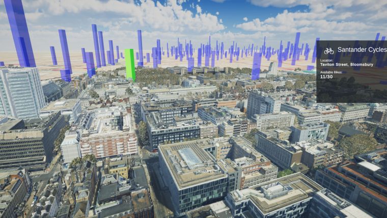
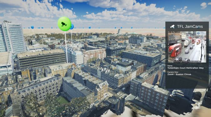
Photorealistic 3D models are being used to produce a new interactive map of London. Created by the Centre for Advanced Spatial Analysis (CASA), part of the Bartlett Faculty of the Built Environment at University College London (UCL), the 3D virtual map brings together live real-time data streams including sensor readings, TFL transport updates and social media information such as geolocated tweets from Twitter. These are then visualized over the Bluesky MetroVista mesh models to provide a live view of the city.
The MetroVista product range uses new aerial mapping technology to simultaneously capture vertical and oblique photography together with laser-scanned height measurements. These provide real-world context for CASA’s mapping platform which is intended to support uses in environmental monitoring, transport, architecture and urban planning.
Greater sense of real-world location
“The value of Bluesky’s MetroVista data is that it provides an immediately recognizable visual reference and context for other, potentially more abstract forms of data,” commented Oliver Dawkins, research assistant at the Bartlett Centre for Advanced Spatial Analysis. “We are so used to seeing real-world imagery with platforms like Google Earth that we can struggle to get a sense of place when presented with more traditional architectural block models.”
“Using MetroVista gives a greater sense of real-world location which can be useful for communicating location-based insights,” Dawkins continued. “The Bluesky data helps users make a connection between the various streams of data we present such as traffic updates or bike hire schemes, and to imagine and explore their relationship with a specific location. The model helps to show where ‘here’ actually is.”
Real-time urban digital twin
CASA has used SafeSoftware FME to pre-process the Bluesky MetroVista data and combine it with further geographic information including map tiles, building footprints and point cloud data. This data can then be imported into a game engine for visualization and interaction by users. The system is backed by a database which stores the attributes of 3D objects in the model. Finally, real-time data from a range of web services and APIs is also streamed into the game engine to create an informationally rich, real-time map of the city: a digital twin.
Captured using the world’s first large-format imagery and Lidar hybrid airborne sensor, Bluesky MetroVista imagery collection includes simultaneously captured oblique and vertical aerial photography. The MetroVista datasets also include geographically accurate, phototextured mesh models ready for use in 3D GIS, CAD and other modelling software as well as visualization, gaming and virtual reality workflows. MetroVista data is currently available for the British cities of London, Birmingham, Manchester, Bristol, Nottingham, Oxford, Cambridge, Brighton, Norwich, Leicester, Derby and Newcastle.

Value staying current with geomatics?
Stay on the map with our expertly curated newsletters.
We provide educational insights, industry updates, and inspiring stories to help you learn, grow, and reach your full potential in your field. Don't miss out - subscribe today and ensure you're always informed, educated, and inspired.
Choose your newsletter(s)


