A Drone Survey of a Wind Farm Access Road
A Whirlwind Mission
Maintaining a large wind farm requires constant and reliable access. UAV technology was successfully used to survey the construction of an access road in a recent project in Norway. Drone technology proved to be the right solution, but there were some challenges that made it a complex process.
More and more countries are building wind turbines to harness the advantages of wind power as they move away from unsustainable fossil fuels. In Norway, 98% of electricity comes from renewable sources. Wind energy is particularly popular, with wind power plant expansion happening both offshore and on land.
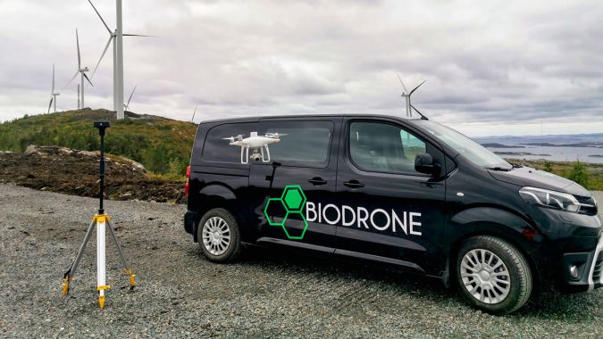
Biodrone is a Norway-based company that offers unmanned aerial vehicle (UAV or ‘drone’) surveying and mapping services across Scandinavia. Typically, its work includes mapping infrastructure such as roads, agricultural spraying and forest inventories. Renewable energy infrastructure is not new to Biodrone, which has inspected dams and wind turbines, including investigating what happens when icicles fall off the turbines in winter. They sometimes land as far as 200 metres (650 feet) away from the huge pillars that support them. This is not surprising in view of the height of the pillars – the tallest in the world is over 240 metres (787 feet) at its highest point.
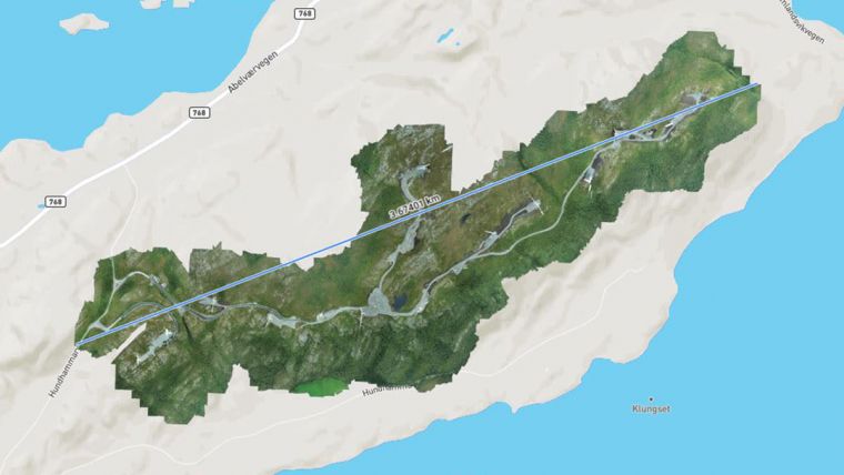
In September 2020, Nærøysund Entreprenør contracted Biodrone to survey a wind farm and document the completion of an access road across the site. Nærøysund Entreprenør had built the roads at the wind farm and needed to compare the final product against the designs before the site could go live and generate wind power. This particular access road is critical to the maintenance of the wind farm. Technicians needs easy access across the whole site in order to fix any broken turbines as soon as possible, as do safety regulators or inspectors.
Planning a challenging flight path
Although using a drone can save surveying time, a wind farm is a complex site since the tall structures present a potential crash risk. The Biodrone team knew that it would be technically challenging to safely survey the land and achieve their goal of highly accurate outputs. The normal height limit for drone flights in Norway is 120 metres (394 feet) but Biodrone received a special permit to fly at a height of 170 metres (570 feet) to survey the site while flying above the turbines. The company also issued a notice to airmen (NOTAM) to warn any nearby pilots of the planned activities. Unusually for a wind farm, the site was not very windy on the day of the flight, which meant that flying was easier with no unpredictable airflow to push the drone off course.
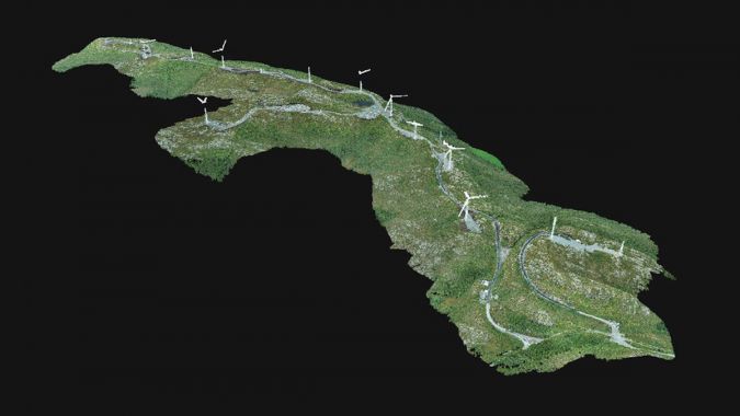
The high-altitude flight at over 120 metres presented a challenge, as Biodrone needed a small ground-sampling distance (GSD) to satisfy the client’s needs. Therefore, after first flying above the wind turbines, the Biodrone team then flew the drone between the pylons. This was time-consuming but necessary to gather the data needed for this project and Biodrone ultimately managed to capture an overall GSD of 3.87cm per pixel (1.5 inches). Meanwhile, maintaining a visual line of sight (VLOS) with the drone helped the pilot to navigate the UAV safely and minimize the danger of it crashing into a wind turbine blade.

The survey of the large site of 2.6km2 (642 acres) generated a lot of data, with over a hundred images per flight, and powerful software was needed for the processing step. Specialized for large-scale mapping, Pix4Dmatic was the chosen solution since it is able to handle very large projects in one go. The 1,245 images and the RTK/PPK data were imported and processed in just two hours. The resulting orthomosaic and point cloud were provided to a third-party consultant working for the wind farm owner.
The shift to renewable energy sources
Drone surveying is not a new concept in the energy sector, which is continuously evolving to meet the demand for renewable power. The move away from fossil fuels can leave behind huge infrastructures which need to be surveyed for redevelopment, and these surveys are often done using drones. Now that wind farm expansion is taking place worldwide, drone surveys will likely become even more commonplace in the future, not least because drones can often save engineers a long and exhausting climb. Similar UAV-based workflows are already in place in telecom tower inspections, showing how useful drones can be for accessing tall structures.
As a result of using drones and Pix4Dmatic, Biodrone was able to survey the access road for the wind farm quickly with the required accuracy.
Click here to explore the point cloud of the wind farm.

Value staying current with geomatics?
Stay on the map with our expertly curated newsletters.
We provide educational insights, industry updates, and inspiring stories to help you learn, grow, and reach your full potential in your field. Don't miss out - subscribe today and ensure you're always informed, educated, and inspired.
Choose your newsletter(s)


