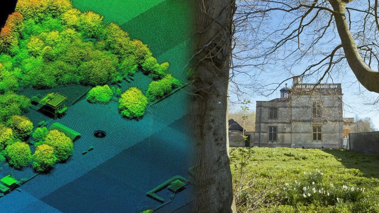
Aerial Laser Survey Answers UK’s National Trust Landscape Questions
The UK's National Trust is using an aerial laser survey to create a 3D map of historically important details of a Grade I listed park in Gloucestershire, England. Bluesky conducted the Lidar survey to help the National Trust gain a better understanding of the significance of the extensive park and gardens at Lodge Park in Sherborne. The Trust was particularly keen to understand and highlight the significance of the work of the renowned English landscape designer, Charles Bridgeman, and the park’s heritage and ecological values.
Charles Bridgeman was a renowned landscape designer who redesigned the parkland at Lodge Park in 1726. It is thought the Lodge Park plan is the only surviving copy of one of Bridgeman’s working drawings, making it immensely important and significant. Bridgeman’s proposals for Lodge Park included planting of the Great Avenue, a grand serpentine canal, as well as several ‘theatres’ of trees.
Lumps and bumps
Historic map evidence has been somewhat inconclusive in determining what of Bridgeman’s landscape features were in fact implemented and still remain, commented Wendy Stott, consultancy manager for historic environment, for the National Trust. Post war aerial photographs similarly record tantalising glimpses of surviving ‘lumps and bumps’. However, the Lidar survey by Bluesky has proved to be most telling of all.
In support of a specially commissioned National Trust Conservation and Management Action Plan, the Lidar survey of Lodge Park has revealed an unexpected level of detail. Remnants pre-dating Bridgeman’s work have been confirmed, including a Neolithic Long Barrow and early parish and other field boundaries, as well as lost features within the park. The Lidar survey has also been able to confirm where Bridgeman’s plans were modified, including a reduction in size of a central ‘bastion’ viewpoint to the west of the Lodge.
Next stage
These initial stages, including the Lidar survey, have been principally about understanding and analysing the remains of the designed landscape, continued Wendy Stott. The next stage will involve balancing these discoveries and agreeing priorities for future management and restoration of this rare and highly significant parkland landscape.
Lodge Park is one of two parks at Sherborne, Gloucestershire, and is a significant element in the National Trust’s Sherborne Estate. It is listed as Grade I on the Register of Parks and Gardens of Special Interest in England and forms part of the National Heritage List. Lodge Park is famous for its mile-long Paddock Course, laid out by John ‘Crump’ Dutton in the 17th Century and the landscaping of soon to be Royal Gardener Charles Bridgeman.

Value staying current with geomatics?
Stay on the map with our expertly curated newsletters.
We provide educational insights, industry updates, and inspiring stories to help you learn, grow, and reach your full potential in your field. Don't miss out - subscribe today and ensure you're always informed, educated, and inspired.
Choose your newsletter(s)


