Agriculture Field Survey System Using GIS Solutions
Inaccurate data collection may result in unwise decisions. To precisely record, measure, and publish the agricultural data in Indonesia, the Ministry of Agriculture of the country developed an Agriculture Field Survey System using GIS solutions to effectively operate agriculture and funding schemes.
Indonesia is a country rich in natural resources inSoutheast Asia. Its agricultural production is the key to the economy ofIndonesiawhich contributes 15% to the GDP, and the farm labour accounts for up to 43% of total employment. To facilitate the sustainable agricultural development,Indonesiagovernment has invested more than USD7 million annually in launching diverse grant-in-aid projects.
With the mission of formulating and implementing policies in agriculture fields, Ministry of Agriculture, Republic of Indonesia (MoA) is responsible for developing a fair trading system in agricultural commodities and enhancing agriculture production through providing agriculturists with proper funding, seeds, insecticide, etc.
GIS
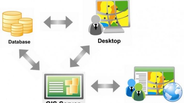
To obtain and manage spatial information of each farmland correctly, MoA developed an Agriculture Field Survey System with SuperGIS mapping solutions that are available in mobile devices, desktop, and server applications to help the MoA personnel maximise field productivity, perform data editing and analysis, as well as integrate and share the latest spatial data and GIS services across the sector.
The Agriculture Field Survey System allows MoA to overcome the disadvantages of the traditional paper-and-pencil survey mode, complete data collection of crop types and conditions, and perform precise measurement of farmland size in each district. As a result, the agency could effectively manage the farmlands and crops, reduce cost of time, labour, as well as unnecessary waste of resources, and formulate feasible funding and agricultural development plans with accurate and up-to-date data.
In this project, the desktop GIS software customised by SuperGIS Desktop3.1a helps MoA easily visualise and analyse field data, ensuring that the integrated agricultural data can be updated and managed through enterprise geodatabase. Besides, server GIS also serves as a full-function platform for data synchronisation, management, and sharing. Therefore, the cost of data duplication and storage could be significantly reduced.
As for data capture, the Agriculture Field Survey System developed by SuperPad 3.1, the full-function mobile GIS, enables surveyors throughout the country to smartly measure farmland areas, add attributes, and take pictures for crops using integrated GIS and GPS technologies. It also ensures that newly collected agricultural data can be uploaded and well managed on server, bringing MoA the real situation of fields, corps, and pesticides in order to make better decisions in encouraging the domestic farming industry.
Custom GIS Solutions
The Agriculture Field Survey System is built on mobile, desktop, and server software to fulfil diverse project requirements. In addition to overlaying layers, editing features, and geo-tagging photos in the field, the mobile GIS software offers an easy-to-use manipulation mode, localized User-Interface for Indonesian speaking users, etc. to reduce labour costs and increase field productivity in an effortless way.
Moreover, the mobile application enhances the connection with SuperGIS Server 3.1, assuring that the officers in central office in Jakarta can view the surveyed data which are uploaded from mobile to server side via Internet connection. A customised website is also developed for the central officers to examine the data reliability in real-time, facilitating decision making more promptly and accurately.
In addition, SuperGIS Desktop3.1ais used to visualise, manage, and process agricultural data of each province in Indonesia for making agricultural related policies. Then, the integrated layers can be published as map services through SuperGIS Server 3.1, to be the base referenced maps after the field workers update the collected data to the server side. The Desktop GIS software fully supports MS SQL Server and Oracle Spatial, ensuring that multiple users are able to access and edit the data simultaneously.
The custom server GIS platform increases the MoA personnel’s ability to systematically monitor and manage fields and crops by accessing dynamic vector data and raster data and use various front-end applications such as customised SuperPad, SuperGIS Desktop, Web applications to view, query, and update data and maps online with ease. Different GIS platforms are combined together to assist in government policy-making for agricultural development.
Conclusion
With an increasing growth of population and the food demand around the world, sustainable agricultural becomes crucial to increase food production and reduce environment degradation. Well management and decision making is key to agricultural productivity. The goal of the project is not only to support MoA’s efforts using GIS solutions to effectively monitor farmland situation but also to yield agricultural and environmental improvement inIndonesia.
An enterprise-lever server GIS platform has improved communication and update by sharing information across the sector and allowed access to the GIS functionality embedded in it. Using the mobile-based survey GIS system ensures accuracy of geographic information in fields that could be used as important data references for MoA to devise and operate proper subsidy schemes for domestic agricultural communities.
The comprehensive GIS solutions built in SuperGIS software have assisted Indonesian government, like MoA in making wise decisions on granting funding with scientific methods, as well as promoting the efficiency in developing subsidy policies to improve the national agricultural development.

Value staying current with geomatics?
Stay on the map with our expertly curated newsletters.
We provide educational insights, industry updates, and inspiring stories to help you learn, grow, and reach your full potential in your field. Don't miss out - subscribe today and ensure you're always informed, educated, and inspired.
Choose your newsletter(s)


