Applanix Introduces Next-generation OEM Solution for Mobile Mapping
Applanix, a Trimble company, has announced the Trimble AP+ Land GNSS-inertial OEM solution for accurate and robust position and orientation for georeferencing sensors and positioning vehicles in land mobile mapping applications.
The solution enables users to accurately and efficiently track and monitor fleets, produce high-definition (HD) maps and 3D models, or act as a reference solution for advanced driver-assistance systems (ADAS) testing, even in the most challenging of GNSS environments.
Challenging GNSS Signal Environments
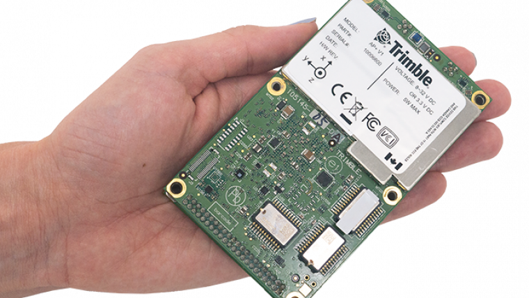
The Trimble AP+ Land is a comprehensive tool for land vehicle applications that is small enough to easily integrate into the most compact mobile mapping systems. It is also compatible with virtually any type of mapping sensor, including single or multi-Lidar systems, video cameras, photogrammetric and panoramic cameras and other similar sensors.
Configurable to meet the mapping, positioning and direct georeferencing (DG) accuracy demands of mapping and positioning applications in challenging GNSS signal environments, the Trimble AP+ Land solution features, amongst others: Applanix IN-Fusion+ GNSS-aided inertial firmware with Trimble ProPoint GNSS positioning technology, dual embedded survey-grade GNSS chipsets that can receive multi-frequency and multi-constellation signals and dual custom-designed inertial measurement units (IMU).
Scalable Positioning Solutions
“We have taken the most advanced features of Applanix inertial and Trimble GNSS technology, and packaged them into a powerful compact and versatile solution optimized for mobile mapping and positioning applications,” said Joe Hutton, Applanix’s director of inertial technology, air and land products. “We remain committed to our customers’ success by developing flexible and scalable positioning solutions such as the AP+ Land and more.”
The Trimble AP+ Land OEM solution is fully supported by the industry-leading Applanix POSPac MMS post-processing software, which features Trimble CenterPoint RTX post-processing for centimetre-level positioning globally without the need for base stations. These capabilities make it a suitable solution for integrators to produce a highly efficient land mobile mapping system.
For Lidar integrators, the Trimble AP+ Land OEM is compatible with the POSPac MMS Lidar QC tools. SLAM technology computes the IMU to Lidar boresight misalignment angles and also adjusts the trajectory to achieve the highest level of georeferencing accuracy in the generated point cloud.

Value staying current with geomatics?
Stay on the map with our expertly curated newsletters.
We provide educational insights, industry updates, and inspiring stories to help you learn, grow, and reach your full potential in your field. Don't miss out - subscribe today and ensure you're always informed, educated, and inspired.
Choose your newsletter(s)


