Ashtech Introduces Web Mission Planning
Ashtech (France) has announced at Intergeo the immediate availability of Web Mission Planning, the first self-contained, completely automatic web-accessible GNSS survey planning tool. Anyone, anywhere can log in at http://www.ashtech.com/ and use the survey-planning tool free of charge to determine satellite visibilities. The new tool developed by Ashtech uses Google Earth mapping and is inter-active and completely self-contained.
Survey planning in advance is important to ensure optimum satellite geometry, to account for mask at the site, and to avoid poor satellite tracking conditions in the field. Surveyors working in urban canyons or under dense tree canopy and GPS-only receiver users find that it is particularly important to prepare their survey by determining in advance the best time and product configuration for optimal satellite visibility and DOP.
The Ashtech Web Mission Planning tool helps surveyors increase productivity. With web access to the free online-tool, there is no need to be at the office anymore to check the next mission, any operator can do it in the field via a simple internet connection, even via smart phone, to ensure survey conditions will be optimal for the next day.
Web Mission Planning is easy to access and use. Once a user has logged-in using a web-browser, Web Mission Planning requires just three steps to provide satellite visibilities.
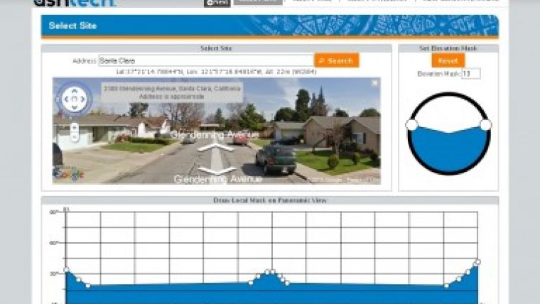
- Step one: select the site using either the integrated Google Maps or key in the location or coordinates.
- Step two: select the time and date range.
- Step three: select the desired satellite constellations, GPS, GLONASS and SBAS, that are to be included. Satellite visibility results are offered in four different views: satellites and count; satellites and DOP (GDOP, PDOP, VDOP, HDOP, TDOP); polar diagram, and a 3D representation.
When selecting the site location, users can either drag and drop the pin marker or key-in the location name or coordinates. For a growing number of coordinates, the user can also display a panorama of the selected site and use it as a basis for marking a site mask. The user can also either apply an elevation mask or draw a specific mask using plots. Time selection is fast and easy. Just pick a start time and date and an ending date and time. Web Mission Planning automatically detects time zones according to selected sites. Satellite selection is also fast and easy. Select or de-select constellations (GPS, GLONASS, SBAS) and or individual satellites.
The results for satellite count and DOP values are presented in clear graphic form. Using mouse over the graphic display, users are able to highlight satellites, times and sums to quickly find the information they need. The satellites and DOP results window offers satellite visibility plus DOP curves. Using the mouse over the graphic display the user is able to display DOP values over time.
Visit http://ashtech.com/ and click on support, then click on Web Mission Planning.

Value staying current with geomatics?
Stay on the map with our expertly curated newsletters.
We provide educational insights, industry updates, and inspiring stories to help you learn, grow, and reach your full potential in your field. Don't miss out - subscribe today and ensure you're always informed, educated, and inspired.
Choose your newsletter(s)


