Australian Gravity Datasets Are Treasure Map for Mineral and Energy Exploration
Australia now has a full suite of new gravity grids at the national scale, being the first publicly released since 2011. The new gravity data adds to the arsenal of products available from Geoscience Australia for exploration purposes. In producing the new national gravity grids a gap analysis was conducted which highlighted areas with low coverage and low quality data. Identifying these regions helped target priority areas for data acquisition under the Exploring for the Future programme.
In the last seven years, over 400,000 gravity observations obtained by Commonwealth, State and Territory governments have been added to Geoscience Australia's database. The availability of gravity data such as the new grids creates a significant efficiency improvement for explorers in Australia and abroad which helps to stimulate exploration activity.
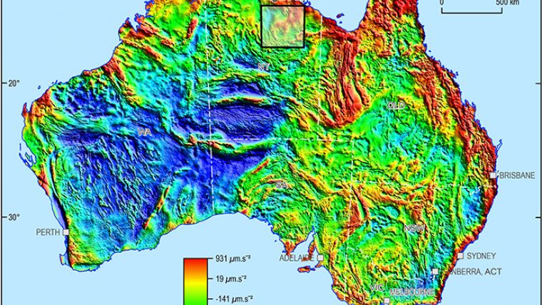
Gravity anomaly grids such as these provide an indication of the variation in the density of rocks across the nation and are an essential tool aiding minerals and energy exploration. Mapping the distribution and patterns of rock density in this way allow geoscientists to map Australia's subsurface geology.
Data for Subsurface 3D Models
Gravity data are one of the main tools used in exploring under sediment cover, which is one of the primary challenges facing minerals exploration globally. The data can be used to create 3D models of the subsurface, providing a better understanding of the structure and geological setting of the nation. Fundamental datasets such as gravity help improve the understanding of the composition and structure of the continent. This information contributes to the assessment of geological structure and mineral potential, paving the way for further exploration for mineral and energy resources.
Minerals and energy explorers can obtain these datasets online for free via the Geophysical Archive Data Delivery System, as well as importing directly to GIS software through web map services.
The new datasets are generated from data stored in the Australian National Gravity Database; and include the Bouguer Gravity Anomaly Grid, Complete Bouguer Gravity Anomaly Grid and the Isostatic Residual Gravity Anomaly Grid. The Bouguer Gravity Anomaly grid shows the difference between the expected gravity response from a uniform Earth and the measured local gravity, taking into account elevation and crustal density.

Value staying current with geomatics?
Stay on the map with our expertly curated newsletters.
We provide educational insights, industry updates, and inspiring stories to help you learn, grow, and reach your full potential in your field. Don't miss out - subscribe today and ensure you're always informed, educated, and inspired.
Choose your newsletter(s)


