Bath First to Integrate CycloMedia Imagery
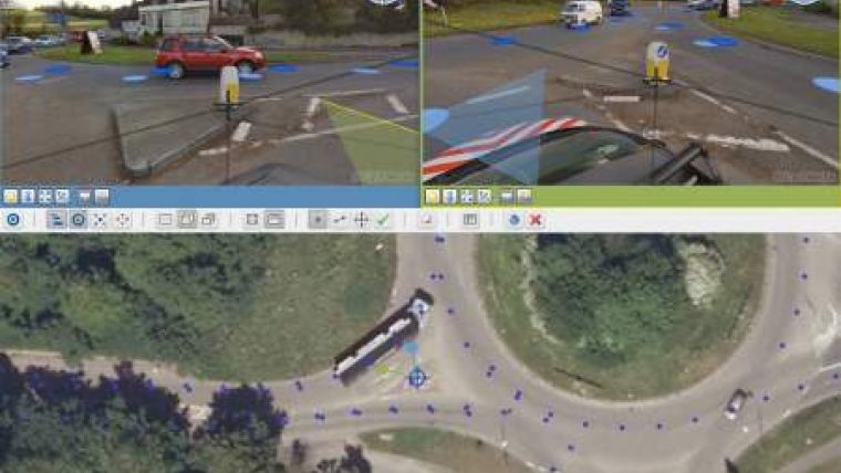
Getmapping has integrated CycloMedia street-level imagery and tools directly into its web-based GIS applications for UK Local Authorities and Parish Councils. Bath and North East Somerset Council and Parish Councils in the region are the first to benefit from locally-accurate, high-resolution street-level images which are seamlessly integrated into the existing mapping applications hosted by Getmapping.
When the CycloMedia module and associated imagery was released by Getmapping, it immediately became available to all staff within the organisation thanks to the convenience of Software as a Service (SaaS). Functionality includes full NLPG (National Land and Property Gazetteer) property-level search with multiple viewing angles displayed in up to three windows. It is also possible to take point and line measurements at sub-centimetre accuracy with full CSV data export. All the data is hosted remotely so there is no hardware overhead. The total solution helps to make staff more productive, reduces the number of site visits and car journeys and therefore cuts carbon emissions.
Martin Laker, GIS manager for Bath & North East Somerset Council, says that CycloMedia imagery makes it possible to reduce staff car usage and Planning, Property and Highways departments are all reporting that they can reduce the number of site visits needed by using it. A 3% reduction will be sufficient to pay for the service. The CRM team are reporting improved response times from being able to find and visualise the property at the outset of a customer call. Being able to validate what is being reported has been improved. All the imagery is date stamped which is a great help in determining when events occur.
"This CycloMedia imagery represents an affordable yet superior alternative to out-of-date, unlicensed Street View imagery increasingly used by Local Authorities today," is the experience of Chris Mewse, GIS business development manager at Getmapping. "By integrating CycloMedia imagery and tools directly into our web applications, users can look at aerial photography, a full range of Ordnance Survey maps and then click straight into detailed geometrically accurate street-level imagery to understand specific detail. They can take accurate measurements, achieving as much from sitting behind their desktop PC as they can from a site visit, allowing users to apply greater accuracy to asset inventories and improve the service the Local Authority provides to its citizens."

Value staying current with geomatics?
Stay on the map with our expertly curated newsletters.
We provide educational insights, industry updates, and inspiring stories to help you learn, grow, and reach your full potential in your field. Don't miss out - subscribe today and ensure you're always informed, educated, and inspired.
Choose your newsletter(s)


