Bluesky Airborne Laser Maps Quarry in 3D
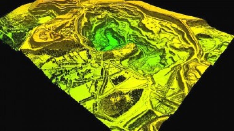
Bluesky (UK) has completed a detailed 3D survey of Lee Moor quarry near Plymouth, Devon. Commissioned by WBB Minerals, one of the world\'s largest suppliers of industrial minerals, the survey captured high-resolution aerial photography together with height measurements using a LiDAR distance measurement system.
WBB Minerals, who recently acquired the working lease for the site, will use the Bluesky data to identify mineral resources, undertake accurate measurements and analysis at the desktop and manage both the day-to-day and long-term extraction activities at the quarry.
Height measurements of the site were captured by using a survey aircraft equipped with a system of lasers (LiDAR). Lasers are beamed to the surface and the time taken for the beam to be bounced back to aircraft mounted receivers is recorded. Then, using the known position of the aircraft, from on-board satellite positioning equipment, the time taken for the return of the laser beam and the known value of the speed of light the distance between the aircraft and ground is calculated. From these height measurements a detailed Digital Terrain Model (DTM) was created, onto which the vertical aerial photography, captured at the same time as the height data, was draped.
Caption: Airborne laser image of the Lee Moor China Clay Quarry near Plymouth, UK.

Value staying current with geomatics?
Stay on the map with our expertly curated newsletters.
We provide educational insights, industry updates, and inspiring stories to help you learn, grow, and reach your full potential in your field. Don't miss out - subscribe today and ensure you're always informed, educated, and inspired.
Choose your newsletter(s)


