Bluesky Launches Online Renewable-energy Platform
This article was originally published in Geomatics World.
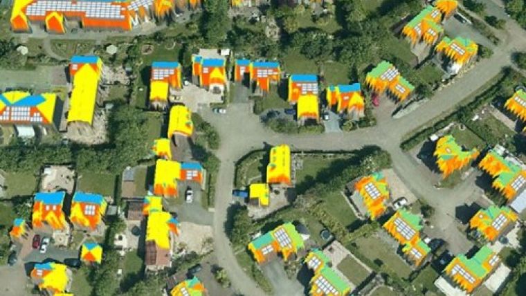
A prototype version has been launched of a website which allows homeowners, solar installers and manufacturers, energy companies and government organisations to assess the suitability of individual properties for solar energy technology. The online system employs high-resolution geographic data, such as aerial photography and Lidar, as well as address records to accurately identify and assess a building’s suitability.
This information is combined with details of actual energy tariffs, expected consumption, cost of installation and available subsidies to calculate the potential return on investment for solar renewable energy systems. The result of a three-year, EUR2.4 million EC-funded research project – the EAGLE Platform – is now demonstrated at www.eaglesolar.eu.
The EAGLE Platform achieves three specific goals, commented James Eddy, technical coordinator for the EAGLE Project and director of UK aerial mapping company Bluesky. It provides easy-to-understand, objective yet accurate information about renewable energy systems for a specific dwelling or building. This allows for the calculation of return on investment for any given scenario as well as potentially reduced installation costs. In turn this information can be used to target consumers with information and educational campaigns, he added.
Geographic data
The research project initially focused on the exploitation of geographic data, such as aerial photography and Lidar, for the automatic extraction of information relating to the suitability of a property for renewable energy generation. The second element of the project, now live, was to create a web-based portal to deliver this information to energy companies, government organisations, installers and individuals, providing unbiased information for selected small areas.
The EAGLE Platform is different, James Eddy explained. Underpinned by a wide spectrum of geographic information, including 3D imaging such as Lidar as well as more traditional aerial photographs, address and cadastre data, it is more accurate, reliable and objective than other systems coming to market.
Other types
Initially focused on solar power generation, the longer-term aims of the project are to also encompass other types of renewable energy such as wind, hydro and ground source heat. It is hoped this will make the EAGLE Platform the industry’s renewables portal, further enhancing Bluesky’s position at the forefront of this technology.
UK-based aerial mapping Bluesky provided technical lead for the EC-funded project with other project partners, including the Solar Trade Association in the UK, Svensk Solenergi of Sweden, Solar Macedonia, Deutsche Gesellschaft für Sonnenenergie from Germany, as well as the Universities of Leicester UK, Karlsruhe and Stuttgart in Germany and Selçuk in Turkey. Two SMEs also participated: SolarTech in the UK and Solimipeks of Turkey. The project was managed by the Chartered Institute of Plumbing and Heating Engineering (CIPHE).

Value staying current with geomatics?
Stay on the map with our expertly curated newsletters.
We provide educational insights, industry updates, and inspiring stories to help you learn, grow, and reach your full potential in your field. Don't miss out - subscribe today and ensure you're always informed, educated, and inspired.
Choose your newsletter(s)


