Bluesky Launches Property Heat Loss Mapper
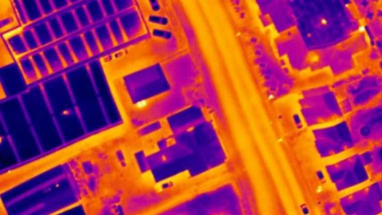
Aerial survey company Bluesky has launched an easy-to-use property heat loss mapper to help Local Authorities view thermal data collected during airborne thermal imaging surveys. The HELIOS (Heat Loss Investigation System) web-based reporting tool, developed by Manchester Geomatics, will help energy and environment teams understand the results of thermal surveys and allow cross-referencing of data with other information.
With fuel poverty and energy consumption high on both the political and personal agenda, HELIOS allows survey results to be presented in a visually appealing and easily understandable way. HELIOS is designed to manage multiple data types enabling the cross-referencing of thermal mapping with geo-demographic data such as Census information, building classification mapping and land use. It also matches address information including the National Land and Property Gazetteer (NLPG), base mapping from Ordnance Survey and other custom data layers such as the energy consumption compiled by BERR.
This combination of information will help Local Authorities identify opportunities to engage with residents and the business community about suitable insulation grants, consumption advice and renewable energy products, thus helping to measure and report on National Indicators and Performance Targets.
"Fuel consumption and energy efficiency are ‘hot' topics impacting not only on the environment but on the purse of every business, household and individual," commented Rachel Tidmarsh, Managing Director of Bluesky. "By providing Local Authorities with up-to-date, building level thermal imagery plus the tools they need to analyse and communicate this information-rich resource we can help reduce consumption, protect at-risk residents and preserve the environment."
The end-to-end solution offered by Bluesky to Local Authorities includes a cost-effective airborne thermal survey service measuring building roof heat loss levels across an entire city in just one evening, plus a bespoke thermal mapping service creating intelligent energy consumption and fuel poverty maps to support energy strategies and local campaigns. Using HELIOS, Councils can now easily analyse complex data from multiple sources and share results with colleagues, partner organisations and members of the public. Bluesky has many years of successfully delivering thermal survey solutions to Local Authorities and help assemble, host and manage a HELIOS installation on behalf of an organisation.
Website: www.bluesky-world.com

Value staying current with geomatics?
Stay on the map with our expertly curated newsletters.
We provide educational insights, industry updates, and inspiring stories to help you learn, grow, and reach your full potential in your field. Don't miss out - subscribe today and ensure you're always informed, educated, and inspired.
Choose your newsletter(s)


