Bluesky Reaches Irish Aerial Survey Milestone
Aerial mapping company Bluesky has reported a successful 2015 flying season in Ireland. Having captured nearly 10,000 square kilometres of high-resolution aerial photography, the company is well on the way to achieving its ambitious plans to capture high-resolution aerial photography for the whole of the Republic of Ireland. Bluesky also announced the early take-up of its groundbreaking Irish datasets, with sales of aerial photography and detailed Lidar height models to early adopters including local government organisations, central government departments and commercial businesses.
Bluesky originally launched its plans to capture high-resolution, leaf-on, aerial photography and colour infrared imagery for the whole of the Republic of Ireland in 2014, and began flying as planned during the spring of 2015. Bluesky has already committed to a three-year update cycle for core data products, and will recommence flying in early spring of 2016 as soon as weather conditions allow.
Weather conditions
Rachel Tidmarsh, managing director of Bluesky, said they are extremely pleased with the amount of high-quality imagery and data they have been able to capture, in spite of the challenging weather conditions experienced this flying season. The interest in this new data from both public and private sector organisations has also been immensely encouraging; the company is already delivering high-quality data products to end users.
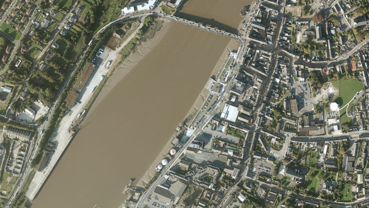
Products from the Bluesky 2015 Irish flying season include 25cm and 20cm resolution coverage for nearly 10,000 square kilometres, including the county of Waterford, and higher-resolution, 12.5cm and 10cm, data for urban areas including Sligo, Limerick, New Ross, Enniscorthy, Gorey and Wexford.
DTM and DSM
In addition to the aerial photography and CIR imagery already captured, national Digital Terrain Models (DTM) at 2m resolution and Digital Surface Models (DSM) at 25cm, 12.5cm and 10cm resolutions, are being created. The first datasets, available in a variety of GIS ready formats, are already being delivered to clients and will soon be available online.
Bluesky’s team is expert in the capture of remotely sensed data and the production of innovative geographic data products. Bluesky’s work includes providing a technical lead in a European Commission funded project into a web based renewable energy rating platform, the laser mapping of overhead power line networks, new technology for air quality mapping, night time thermal surveying and the creation of the National Tree Map (NTM).

Value staying current with geomatics?
Stay on the map with our expertly curated newsletters.
We provide educational insights, industry updates, and inspiring stories to help you learn, grow, and reach your full potential in your field. Don't miss out - subscribe today and ensure you're always informed, educated, and inspired.
Choose your newsletter(s)


