Brandenburg Metadata Service
A few days ago a Service Portal for Metadata was launched by the Spatial Data Infrastructure Berlin/ Brandenburg (GDI-BE/BB). The Landesvermessung und Geobasisinformation Brandenburg (LGB) and geoinformation service provider DELPHI IMM GmbH of Potsdam have announced official ending of the test phase of the Service Portal, which represents a reliable and freely available 24-hour solution for Brandenburg county administration and regional service providers for capturing, collecting, validating and publishing meta-information from their geo-data, geo-services and geo-applications.
Core element of a Spatial Data Infrastructure (SDI) is the seizure of the supply of metadata of geo data and geo services that are available within a spatial data infrastructure. Long-term experiences in the field of SDI qualify the LGB and DELPHI IMM to be aware of the need for metadata but the unpopularity of the capture and management of metadata since both are not easy to implement and do not show direct benefits to the user. Consequently, the LGB and DELPHI IMM have initiated a cooperation aiming at the facilitation of the access of public bodies to software tools for the capture, maintenance and distribution of metadata. In the course of a grant project of the land Brandenburg funded by the European Regional Development Fund (ERDF) DELPHI IMM has developed a web application based on the software products issued under the brand ‘geoway solutions‘. The web application is published on ‘metadaten-serviceportal.de‘ and is continuously supervised by DELPHI IMM. The LGB acts as professional contact person and administrator to serve authorities of the land Brandenburg.
Participants of the GDI-BE/BB like municipalities and regional government authorities in Berlin and Brandenburg as well as representatives of the private sector and scientific institutions will benefit with the help of the service portal from a definite simpler and more flexible handling of metadata management facing the present requirements of INSPIRE (Infrastructure for Spatial Information in Europe).
The Service Portal for Metadata realizes an online tool encompassing several modules to guarantee the consistent capture and management of metadata while complying with high quality standards.
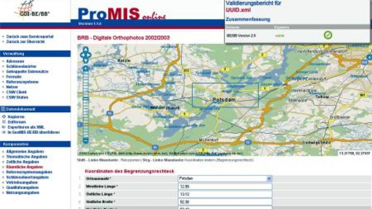
The Metadata Editor ProMIS-Online (based on geoway catalogue) serves the user to capture and manage metadata in compliance with the BE/BB metadata profile 2.0. The recorded metadata then can be published and transferred by the user in an OGC and INSPIRE compliant Web Catalogue Service geoway interface (CS-W 2.0.2). Access rights will be disposed by the LGB. A highlight of the portal is the Metadata Validator (based on geo-way validator), a software that gives the user the opportunity to easily validate externally recorded metadata against the BE/BB profile 2.0. The validator can be run to validate single metadata documents (*.xml) or complete archives (*.zip). The validation process is characterised by a multilevel web-based testing, a display of test results and an explicit problem report supplied as pdf download. The most important software component of the portal takes the backseat and remains completely invisible for the user: geoway manager serves as a management component for the collection of metadata of registered sources and their automatic transfer into the central geo portal GeoMIS-BE/BB. This facilitates the pan-European supply of the complete metadata of the GDI-BE/BB for the Spatial Data Infrastructure Germany (GDI-DE) and the European Spatial Data Infrastructure according to INSPIRE. Further standard-compliant CS-Ws of the SDI can be registered optionally in the service portal and complement the portal's metadata editor ProMIS-Online and the CS-W.
The activation of the Service Portal for Metadata finally paves the way to a reliable and secure exchange of meta-information on a regional, national and international level while meeting internationally accepted standards and supporting decision makers in the field of environment, geology and surveying with sound spatial data.
Above all, the software presents THE central ‘Metadata Node‘ for all participants of the GDI-BE/BB.

Value staying current with geomatics?
Stay on the map with our expertly curated newsletters.
We provide educational insights, industry updates, and inspiring stories to help you learn, grow, and reach your full potential in your field. Don't miss out - subscribe today and ensure you're always informed, educated, and inspired.
Choose your newsletter(s)


